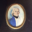
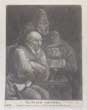
| New Stock |
Images |
(Code No. 6975)
Anon.
Portrait Miniatures:watercolour.
England. Frame size, [4 1/4 x 6ins]. (approx) image size 2 x 2 3/4ins].
Date (c.1820)..
Original watercolour housed in a gilt decorative frame, possibly John Buttler written on back. (very faded ).... £120.00 |
Click on picture above to view more images
How to order |
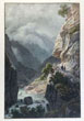
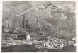
(Code No. 6974)
Villeneuve, Jules-Louis-Frédéric (1796-1842).
Sentiér taille dan le Roc Vallée d'Oberhasli.
(Canton de Berne).
(Antique Lithographic print).
Date (c.1830).
Paris, .Engelamnn, Page size 16 1/2 x 12ins. Image size 11 x 7 1/2 ins, Hand coloured lithographic print heightened with gum arabic,very good condition. From the path leading to Oberhasli, view of precipices. The waterfall is all the more impressive as it brings together the Aare and the Aerlenlach......... £55.00 |
Click on picture above to view more images
How to order |
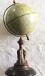
(Code No. 6971)
Anon
Terrestrial Globe..
Date. (c.1930).
British. Height 10 inch, diameter of globe 4 1/2inch.An 4 1/2-inch diameter. Metal coloured terrestrial table globe On circular gilt metal and stone base, some surface abrasions. Showing, steamship routes with ports of arrival and departure and distance in nautical miles...... £75.00 |
Click on picture above to view more images
How to order |
(Code No. 6970)
Scrap album...
Date (c.1912).
British. Size (4 x 5 1/2ins) Original scrap album with approx 10 pages of text + 8 ink sketches + 9 water colours + 1 pencil sketch all by various artists. Full morocco gilt, slight loss to top of spine...... £30.00 |
Click on picture above to view more images
How to order |
(Code No. 6969)Jenssen Int & Billings Advert.Date (c.1930).Jenssen Int & Billings swing toy advertisement in the form of the east and west hemispheres.. Size approx 18 x 7 1/2 ins.Rare original metal pendulum advertising sign in 2 pieces, the illustrated pendulum with the east and west hemispheres painted with a ship and car travelling around the top of the world when the pendulum swings.slight wear to base.....
|
SOLD.
|
(Code No. 6967)
The Psalm Smiters.
(Antique Print).
Date. [c.1769].
London, Printed for Bowles & Carver. Image size [4 1/2 x 6ins.] Original mezzotint engraved print, Dust marks to edge of margins.....
But at my stumbling they rejoiced and gathered themselves together;
The smiters whom I did not know gathered together against me,
They slandered me without ceasing. —Psalm 35:15 ... £35.00 |
Click on picture above to view more images
How to order |
(Code No. 6966)
Schmied, D.A.
(antique aquatint print)
L'hospice du Grimsel cant de Berne..
Date. (c.1830}.
Switzerland, Zurich, Fuissly & Co...Page size approx [9 x 12 ins]. Original aquatint print engraved by D.A Schmied.taken from an original drawing by J. Sperli ,. , ..
Showing :The Grimsel Pass formed, along with the Nufenen and Gries passes, a regional trade route between the Haslital and Domodossola and the Lombardy plain. Cheese and cattle were sent south, whilst wine, rice, corn and olive oil came north. This trade continued until the opening of the Gotthard railway in 1882...... £35.00 |
Click on picture above to view more images
How to order |
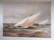
(Code No. 6965)
SHIELDS, Henry & James. MEIKLE.
( Antique Print).
Famous Clyde Yachts 1880-87.
Plate 23.
London: Oatts & Rungman. Large folio,(approx). [15 x 20ins]. Image size [8 x 11ins].. Date. 1888, First and only Edition. Original chromolithographic print (coloured prints), taken from an original water colour by Henry Shields......, £100.00 |
Click on picture above to view more images
How to order |
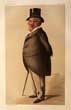
(Code No. 6964)
Original Vanity Fair Print .
(Antique Print).
Brand, James.
Date. 26th May 1888.
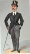
London. "Vanity Fair" Office. Page size, (approx), [10 1/4 x 14 1/2 ins] Guaranteed original coloured lithograph, engraved by Day & Son from a drawing by Spy Titled “Telephones.”
Chairman of the pioneering United Telephone Company, and of Harvey, Brand & Co, East India & China Merchants...... £25.00 |
Click on picture above to view more images
How to order |
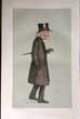
(Code No.6962)
An Original Vanity Fair Lithograph.
Russell, Thomas Wallace. MP.
Date.24th-March-1888.
London, Page Size [8 1/2 x 14ins]..Original Vanity Fair coloured lithographic print, ..Caption "loyal and patriotic"
Russell's views on Home Rule underwent a change around the turn the century and he gradually became a critic of Unionist policies in Ireland. From 1900 put himself at the head of the Farmers and Labourers Union, an Ulster tenant-farmer protest movement demanding compulsory land purchase, similar to the land and labour movement in the south. His 1901 book Ireland and the Empire was an attack on the Irish agrarian system. From 1902 to 1903 he was a key Ulster farmer representative at the Dublin "Land Conference" which resulted in the passing of the Land Purchase Act of 1903. This defused the Protestant tenant-farmers' revolt....... £25.00
|
Click on picture above to view more images
How to order |
(Code No. 6961
) An Original Vanity Fair Lithograph.
Pickersgill, Edward. Hare MP.
Date. 31th-March-1888.
London, Page Size [8 1/2 x 14ins].. Original Vanity Fair coloured lithographic print, ..Caption "Bethnal Green"
Pickersgill was elected Member of Parliament for Bethnal Green South West. He was regarded as being on the Radical wing of the Liberal Party, and campaigned for reform of criminal law, in particular seeking to end imprisonment for non-payment of debt. He also sought the abolition of the death penalty and the ending of flogging as a punishment........ £25.00 |

Click on picture above to view more images
How to order |
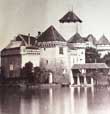
(Code No. 6960)
Charles Soulier. (In the style of).
Le Chateau de Chillon.
Date. (c.1870).
Paris. Image size [6 x 7 1/2ins] Original oval albumen photograph laid on to card, in the style of Charles Soupier of the Le Chateau de Chillon..
.Charles Soulier a French topographical photographer. Active during the second half of the nine-tenth century, particularly with very fine views of Mont Blanc, French and Swiss topography, Roman architecture and sculptures; many, taken in partnership for publication as stereoscope slides on glass......... £70.00 |
Click on picture above to view more images
How to order |
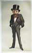
(Code No. 6959)
An Original Vanity Fair Lithograph.
Barkly, Henry. KCB GCMG.
Date. 1887-07-09.
London, Page Size [8 1/2 x 14ins].. Original Vanity Fair coloured lithographic print, ..Caption "The Cape of Good Hope"
Barkly was sworn in as Governor and Commander-in-Chief of British Guiana on 12 February 1849. His family connections with British Guiana and the West Indies in general served him well as governor of the colony, and prompted Lord Grey, the Secretary of State for War and the Colonies, to refer to his "remarkable skill and ability" in addressing the colony's economic issues by widening the franchise of the College of Kiezers. In 1853, he was transferred to Jamaica and served three years. In November 1856, Barkly was appointed Governor of Victoria, Australia, arriving in Melbourne on 24 December 1856. He achieved one of his main goals of stable government. In August 1870 he was sent to the Cape of Good Hope as Governor of Cape Colony and as British High Commissioner for Southern Africa. He helped to implement responsible government in the Cape and worked closely with John Molteno, its first elected Prime Minister....... £25.00 |
Click on picture above to view more images
How to order |
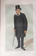
(Code No.6958)
An Original Vanity Fair Lithograph.
Dillon, John MP.
Date. 7th May 1887.
London, Page Size [8 1/2 x 14ins].. Original Vanity Fair coloured lithographic print, ..Caption "the Plan of Campaign"
Dillon became a leading land reform agitator as member of the original committee of the Irish National Land League, spearheading the policy of "boycotting" advocated by Michael Davitt with whom he was allied in close friendship. and was at first an ardent supporter of Charles Stewart Parnell. He travelled to the United States with Parnell on a fund-raising mission for the Land League. On his return he denounced William Ewart Gladstone's Land Act of 1881 as achieving nothing for small farmers. His views on agrarian reform and on Home Rule led him being branded an extremist, which resulted in his arrest from May until August 1881 under the Irish Coercion Act.......... £25.00 |
Click on picture above to view more images
How to order |
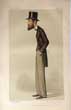
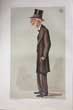
(Code No. 6957)
An Original Vanity Fair Lithograph.
Pitt-Lewis, George, QC MP.
Date, May 28th 1887.
London, Page Size [8 1/2 x 14ins].. Original Vanity Fair coloured lithographic print, ..Caption "Barnstaple"
Pitt-Lewis father, grandfather and great-grandfather were successively headmasters of Honiton Grammar School, which he himself attended. He was called to the bar at Middle Temple in 1870.. He went on the Western Circuit and was one of the originators ofThe Bar Committee.. He became a Queens Counsel in 1885 and became Recorder of Poole. Pitt-Lewis was elected Member of Parliament for the Barnstaple division of Devon at the 1885 general election, representing initially the Liberal Party,. His stated recreations included freemasonry and tricycling...... £25.00 |
Click on picture above to view more images
How to order |
(Code No. 6955)
An Original Vanity Fair Lithograph.
Miall, Edward, MP.
Date. 29th July. 1871.
London, Page Size [8 1/2 x 14ins]..Original Vanity Fair coloured lithographic print, ..Caption "The Nonconformist"
Miall was never able to secure a Parliamentary majority for disestablishment of the Church of England but a long fight for the abolition of compulsory church-rates was finally successful in 1868, and then in 1870 Miall was prominent in the discussions aroused by the Education Bill. He was at this time Member of Parliament for Bradford (1860-1874), having previously sat for Rochdale from 1852 to 1857. In 1874 he retired from public life, and received from his admirers a present of ten thousand guineas. He died at Sevenoaks...... £25.00 |
Click on picture above to view more images
How to order |
(Code No. 6954)
An Original Vanity Fair Lithograph.
Crossley SB, Sir MP.
Date. Nov 17th 1888.
London, Page Size [8 1/2 x 13 1/2ins].. Original Vanity Fair coloured lithographic print, .. Caption "Lowestoft"
Entered the House of Commons on 24 November 1885 General election
Left the House of Commons on 8 January 1906 General election, Also represented Lowestoft.........£25.00 |
Click on picture above to view more images
How to order |
(Code No. 6953)
An Original Vanity Fair Lithograph.
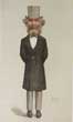
Haweis ,Reverend Hugh Reginald.
Date. September 22nd 1888.
London, Page Size [8 1/2 x 13 1/2ins]. . Original Vanity Fair coloured lithographic print, edge nick not affectong image.. Caption "The Parson, The Play and the Ballet"
His unconventional methods of conducting the service, combined with his dwarfish figure and lively manner, soon attracted crowded congregations. He married Mary E. Joy in 1866, and both he and Mrs Haweis contributed largely to periodical literature and travelled a good deal abroad. Haweis was Lowell lecturer in Boston, in 1885, and represented the Anglican Church at the Chicago Parliament of Religions in 1893. ..... £25.00 |
Click on picture above to view more images
How to order |
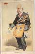
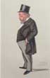
(Code No. 6952)
ZETLAND. Earl of.
An Original Vanity Fair Lithograph.
Date. Dec 1869.
London, Page Size [8 1/2 x 13 1/2ins]. Original Vanity Fair coloured lithographic print. Caption "The Most Worshipful Grand Master"
Lord Zetland was the United Grand Lodge of England's Grand Master from 1844 to 1870. Zetland was a senior member of the Jockey Club and won the Epsom Derby and St Leger Stakes with his horse Voltigeur in 1850.........£30.00 |
Click on picture above to view more images
How to order |
(Code No. 6951).
Original Vanity Fair Print .
Bradley. GG..The Very Rev.
Date. 09-29-1888.
London. "Vanity Fair" Office. Page size, (approx), [9 1/4 x 14 1/2 ins]Guaranteed original coloured lithograph - Titled -"The Dean of Westminster"
.George Granville Bradley, CVO, DD ( 1821 – 1903) was an English divine, scholar, and schoolteacher, who was Dean of Westminster (1881–1902)......£25.00 |
Click on picture above to view more images
How to order |
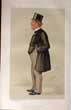
(Code No. 6950)
Original Vanity Fair Print .
Payn, James.
Date. 09-08-1888
London. "Vanity Fair" Office. Page size, (approx), [9 1/4 x 14 1/2 ins] Guaranteed original coloured lithograph - Titled -"The Heir of the Ages"
.Payn settled in the Lake District to a literary career and contributed regularly to Household Words and Chambers's Journal. In 1858 he moved to Edinburgh to act as joint editor of the latter, and became its sole editor in 1860. He conducted the magazine with much success for 15 years. In the meantime he removed to London in 1861. In the pages of the Journal he published in 1864 his most popular story, Lost Sir Massingberd. From this time he was engaged in writing novels........... £25.00 |

Click on picture above to view more images
How to order |
(Code No. 6949)
Original Vanity Fair Print .
Cathcart, Alan Frederick 3rd Earl Cathcart.
Date . 14th. April. l 1888.
London. "Vanity Fair" Office. Page size, (approx), [9 1/4 x 14 1/2 ins] Guaranteed original coloured lithograph - Titled -"He has devoted his life to husbandry and has nine children" .
He was a Deputy Lieutenant of the North Riding of Yorkshire and President of the Royal Agricultural Society. His eldest son, the fourth Earl, was also a Deputy Lieutenant of the North Riding of Yorkshire...... £25.00 |
Click on picture above to view more images
How to order |
(Code No. 6948)
Original Vanity Fair Print .
Upton, George Frederick 3rd Viscount Templetown.
Date. 08-18- 1888.
London. "Vanity Fair" Office. Page size, (approx), [9 1/4 x 14 1/2 ins] Guaranteed original coloured lithograph - Titled -"Upty" .
He was a major and brevet colonel in command of 1st Battalion in the Crimea in 1854-55, taking part in the Battles of the Alma and Inkerman and was made CB in 1855 and major general in 1858. He was made a commander of the Legion of Honour in 1856[5] and awarded the Order of the Medjidie (fourth class) in 1858. In 1859 he was returned to parliament for County Antrim, a seat he held until 1863,[7] when he succeeded his childless elder brother in the viscountcy. In 1866 he was elected an Irish Representative....... £25.00 |
Click on picture above to view more images
How to order |
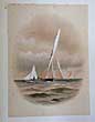
(Code No.6947).
SHIELDS, Henry & James. MEIKLE.
( Antique Print).
Famous Clyde Yachts 1880-87.
Plate 21.
Date. 1888, First and only Edition.
London: Oatts & Rungman. Large folio,(approx). [15 x 20ins]. Image size [8 x 11ins].. . Original chromolithographic print (coloured prints), taken from an original water colour by Henry Shields......£100.00 |
Click on picture above to view more images
How to order |
Code No.(6946)
SHIELDS, Henry & James. MEIKLE.
( Antique Print).
Famous Clyde Yachts 1880-87.
Plate 20.
Date. 1888, First and only Edition.
London: Oatts & Rungman. Large folio,(approx). [15 x 20ins]. Image size [8 x 11ins].. Original chromolithographic print (coloured prints), taken from an original water colour by Henry Shields... £100.00 |
Click on picture above to view more images
How to order |
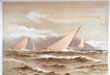
(Code No. 6945)
SHIELDS, Henry & James. MEIKLE.
( Antique Print).
Famous Clyde Yachts 1880-87.
Plate 22.
Date. 1888, First and only Edition.
London: Oatts & Rungman. Large folio,(approx). [15 x 20ins]. Image size [8 x 11ins].. Original chromolithographic print (coloured prints), taken from an original water colour by Henry Shields,...... £100.00 |
Click on picture above to view more images
How to order |
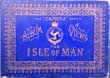
(Code No. 6944)
Album of Camera Views,
The Isle of Man.: The "Camera" Series.
Date. (c.1900).
The Isle of Man, Douglas, Mark Parkinson. Oblong 8vo [12 x 8 1/2ins]. . Many photogravure photographs on 19 leaves, one plate with centre fold split, no loss. Loose gilt decorated boards, splits with some surface loss. Damage to edge of map, no image loss....... £30.00 |
Click on picture above to view more images
How to order |
(Code No. 6943)
Original Vanity Fair Print .
Markham.,Gen Sir Edwin.
Date. 1902-09-18.
London. "Vanity Fair" Office. Page size, (approx), [9 1/4 x 14 1/2 ins]. Guaranteed original coloured lithograph - Titled -"RMC"
Markham was educated at the Royal Military Academy, Woolwich. He passed out and commissioned into the Royal Artillery in 1850 Markham served in the Crimean War and the Eastern campaign of 1854, and up to January 1855, including the affair of M'Kenzie's Farm, the Battle of Alma and the Battle of Inkerman, the Siege of Sevastopol and repulse of the Russian sortie on 26 October 1854 (he was awarded the medal with three clasps, appointed a Knight of the Legion of Honor and awarded the Turkish Medal). He served in India in 1858, and was present at the action of Secundra on 23 January 1858 (he was awarded the medal). He was appointed Lieutenant Governor of Jersey in 1892 and went on to be Director General of Ordnance in 1896 before being made Governor and Commandant of the Royal Military College, Sandhurst in 1898..... £25.00 |
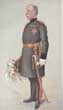
Click on picture above to view more images
How to order |
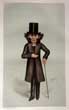
(Code No. 6942)
Original Vanity Fair Print .
Greville, Sidney Robert CB.
Date. 31 May 1900.
London. "Vanity Fair" Office. Page size, (approx), [9 1/4 x 14 1/2 ins]. Guaranteed original coloured lithograph - Titled -"A Private Secretary" Sir Sidney Robert Greville KCVO CB ( 1866 – 1927) was a British civil servant and courtier who held several appointments in the Royal Households of the United Kingdom.,,,,,,, £25.00 |
Click on picture above to view more images
How to order |
(Code No. 6941).
Original Vanity Fair Print .
Wood, Henry Evelyn. Field Marshal Sir VC, GCB, GCMG.
Date. 1879-11-15.
London. "Vanity Fair" Office. Page size, (approx), [9 1/4 x 14 1/2 ins]. Guaranteed original coloured lithograph - Titled -"the Flying Column"
Sir Henry Evelyn Wood, (1838 -1919) was a British Army officer. After an early career in the Royal Navy, Wood joined the British Army in 1855. He served in several major conflicts including the Indian Mutiny where, as a lieutenant, he was awarded the Victoria Cross, the highest award for valour in the face of the enemy that is awarded to British and Commonwealth forces, for rescuing a local merchant from a band of robbers who had taken their captive into the jungle, where they intended to hang him. Wood further served as a commander in several other conflicts, notably the Third Anglo-Ashanti War, the Anglo-Zulu War, the First Boer War and the Mahdist War. His service in Egypt led to his appointment as Sirdar where he reorganised the Egyptian Army. He returned to Britain to serve as General Officer Commanding-in-Chief Aldershot Command from 1889, as Quartermaster-General to the Forces from 1893 and as Adjutant General from 1897. His last appointment was as commander of 2nd Army Corps (later renamed Southern Command) from 1901 to 1904.......... £25.00 |

Click on picture above to view more images
How to order |
(Code No.6940).
Original Vanity Fair Print .
Edwards, John Passmore.
Date. 1885-10-17.
London. "Vanity Fair" Office. Page size, (approx), [9 1/4 x 14 1/2 ins]. Guaranteed original coloured lithograph - Titled -"The Echo"
A lifelong champion of the working classes, Passmore Edwards is remembered as a generous benefactor. Over the space of 14 years, 70 major buildings were established as a direct result of his bequests. These included hospitals, 11 drinking fountains, 32 marble busts, 24 libraries, schools, convalescence homes and art galleries and the Passmore Edwards Settlement in Tavistock Place. He was also a generous donor to the Workers' Educational Association. Many of Passmore Edwards' buildings were designed by the architect Maurice Bingham Adams, who was also the editor of one of his journals, Building News........ £25.00 |
Click on picture above to view more images
How to order |
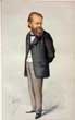
(Code No. 6939)
Original Vanity Fair Print .
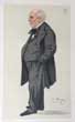
Rose, Sir Philip.Bt.
Date. 1881-05-14.
London. "Vanity Fair" Office. Page size, (approx), [9 1/4 x 14 1/2 ins]... Guaranteed original coloured lithograph - Titled -"Lord Beaconsfield's friend"
At the age of 25, reputedly after one of the clerks at the law firm who was suffering from consumption was refused admittance to several hospitals, Rose was a prime mover in the setting up of a hospital, the Hospital for Consumption and Diseases of the Chest, for sufferers of tuberculosis without the financial means to pay for such treatment as was available at the time. Rose was Honorary-Secretary of the hospital from its inception until his death.......... £25.00 |
Click on picture above to view more images
How to order |
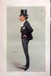
(Code No.6938)
Original Vanity Fair Print .
Chenery, Thomas.
Date. 1879-10-04.
London. "Vanity Fair" Office. Page size, (approx), [9 1/4 x 14 1/2 ins]. . Guaranteed original coloured lithograph - Titled -"Times"
Thomas William Chenery (1826 -1884) was an English scholar and editor of the British newspaper The Times. His diplomatic background and choice of capable reporters helped to revive the paper's reputation for international news........£25.00
|
Click on picture above to view more images
How to order |
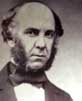
(Code No. 6936)
Anon.
(antique portrait photograph).
Photograph of a scientist with microscope.
Date. [c.1860].
British, Image size (7 1/2 x 5 3/4ins).Original albumen photograph within a rustic surround......... £60.00
|
Click on picture above to view more images
How to order |
Return to top |