SITE CONTENT
Antique Maps & Prints
Britain
Antique Maps - World
Antique Books
Cartographers
Early Prints
Other Stock
|
| Maps, Prints & Books of Europe |
Images |
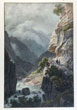
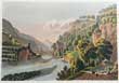
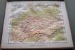
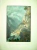
(Code No. 6974)
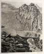
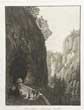
Villeneuve, Jules-Louis-Frédéric (1796-1842).
Sentiér taille dan le Roc Vallée d'Oberhasli.
(Canton de Berne).
(Antique Lithographic print).
Date (c.1830).
Paris, .Engelamnn, Page size 16 1/2 x 12ins. Image size 11 x 7 1/2 ins, Hand coloured lithographic print heightened with gum arabic,very good condition. From the path leading to Oberhasli, view of precipices. The waterfall is all the more impressive as it brings together the Aare and the Aerlenlach......... £55.00 |
Click on picture above to view more images
How to order |
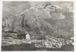
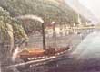
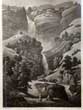
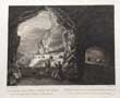
(Code No. 6966)
Schmied, D.A.
(antique aquatint print)
L'hospice du Grimsel cant de Berne..
Date. (c.1830}.
Switzerland, Zurich, Fuissly & Co...Page size approx [9 x 12 ins]. Original aquatint print engraved by D.A Schmied.taken from an original drawing by J. Sperli ,. , ..
Showing :The Grimsel Pass formed, along with the Nufenen and Gries passes, a regional trade route between the Haslital and Domodossola and the Lombardy plain. Cheese and cattle were sent south, whilst wine, rice, corn and olive oil came north. This trade continued until the opening of the Gotthard railway in 1882...... £35.00 |
Click on picture above to view more images
How to order |
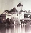
(Code No. 6960)
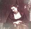
Charles Soulier. (In the style of).
Le Chateau de Chillon.
Date. (c.1870).
Paris. Image size [6 x 7 1/2ins] Original oval albumen photograph laid on to card, in the style of Charles Soupier of the Le Chateau de Chillon..
.Charles Soulier a French topographical photographer. Active during the second half of the nine-tenth century, particularly with very fine views of Mont Blanc, French and Swiss topography, Roman architecture and sculptures; many, taken in partnership for publication as stereoscope slides on glass......... £70.00 |
Click on picture above to view more images
How to order |
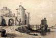
(Code No. 6914)
Raze, L.L.
(Antique Print).
View near Holland.
Date. 1862.
Paris, (Lemercier & Co). Page size, [11 x 15ins]. Original lithograph nicks & dust marks to outer margins just affecting engraved image.
Showing: - Castle and water front. Louis Laurent Raze was the best known Drawing Master at the King's School, Canterbury, in the 19th Century. Born at Cambrai in France, he came to England in 1823 and settled in Canterbury. He was at the King's School from approximately 1842 to 1864. An exhibition of his work was at the Canterbury Museum and Art Gallery some years ago. Canterbury Museum have a collection of his works as does The King's School. Raze is best known for his views of Canterbury, but the exhibition also included several Italian scenes. ...........£35.00 |
Click on picture above to view more images
How to order |
(Code No. 6913)
Geisser, J.
(antique print).
The Castle of Chillon.
Date. [c.1830].
Switzerland, Basel. Verlag, .Image size 7 x 5 ins Original hand coloured aquatint print of Schloss Chillon by J, Rdisuhli, heightened with gum arabic. Some marginal foxing. The medieval fortress on the shores of Lake Geneva near Montreux is the most visited monument in Switzerland. ........£35.00 |

Click on picture above to view more images
How to order |
(Code No. 6912)
Gendall, J.
Bridge of St Maurice.
Date. 1824.
London, R. Ackermann.. Image sizes [7 x 5 ins] Original hand coloured aquatint print of Bridge of St Maurice, Switzerland.
Taken from Ackermann's Repository of Art. Volume 3....... £35.00 |
Click on picture above to view more images
How to order |
(Code No. 6910)
Siegfried.
(antique coloured print).
FLUELEN, vers le Bristenstock.
Date. [c.1830].
London, Zurich, Dikenmann. Image size 7 x 5 ins. Original hand coloured aquatint print of Fluelen at the end of Uri Lake. .....£50.00 |
Click on picture above to view more images
How to order |
(Code No. 6907)
Anon.
(antique coloured aquatint print).
Pierre Pertuis passage remarguable au Canton de Berne.
Date. (c.1830).
Switzerland,. Page size [8 x 6 1/2 ]. Image size [4 x 3ins] Original hand coloured aquatint print.
Showing:- The pass connecting Sonceboz in the valley of Saint - Imier with Tavannes in the valley of Tavannes , called the Orval . It rises to 827 m and makes the join between the Montoz and the Montagne du Droit . The Birse has its source at its foot....... £45.00 |
Click on picture above to view more images
How to order |
(Code No. 6906)
Locher.J. H.
(antique aquatint print).
Le Monument des Suisses du 10 Août 1792.pres Lucerne, Helvetiorum fidei ac virtuti "To the loyalty and bravery of the Swiss"
Date. (c.1830).
Switzerland,.Zurich, J. H. Locher, Page size [7 1/2 x 6 ins]. Image size [4 1/2 x 3 1/4ins] Original aquatint print engraving by J. H. Locher " J. H. Locher,sous la Cigogne".
Showing:- The monument is dedicated Helvetiorum Fidei ac Virtuti ("To the loyalty and bravery of the Swiss"). The dying lion is portrayed impaled by a spear, covering a shield bearing the fleur-de-lis of the French monarchy; beside him is another shield bearing the coat of arms of Switzerland....... £45.00 |
Click on picture above to view more images
How to order |
(Code No. 6904)
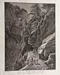
Siraub.
(antique aquatint print).
Pont du Diable sur la route St Gotthardt.--The Devil's Bridge on Mount St-Gotthardt in Canton Ury.
Date. (c.1830}.
Switzerland, Zurich, H.E.Leuthold..Page size approx [9 3/4 x 13 ins]. Original aquatint print engraved by wober.taken from an original drawing by Siraub, ..
Showing :After the wars of coalitions, economic difficulties reigned in the canton of Uri. Due to lack of resources, the bridge and the path could no longer be renovated and traffic to the south became more and more diverted to the Splügen Pass . It was only in 1820 that a contract was established for the construction of a second bridge, which will be completed in 1830, after ten years of work. After the completion of the second bridge, the first bridge is abandoned. It finally collapsed on August 2, 1888. On the left bank, its foundations are still visible. In the middle of the 20TH Century, the second bridge became too narrow, in view of the ever increasing traffic, a third bridge, wider, extended tunnel, was built nearby between 1955 and 1956. ....... £65.00 |
Click on picture above to view more images
How to order |
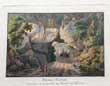
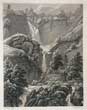
(Code No. 6903)
Anton Winterlin (1801-1894).
(antique aquatint print).
Cascade du Reichenbach.
Date. (c.1830}.
Switzerland, Zurich, Henry Fuseli & Co. Page size approx [10 x 13 1/2ins]. Original aquatint print engraved by Ruffso.taken from an original drawing by Anton Winterlin, damp stain to out side edge not affecting image...
Showing :- Cascade du Reichenbach. Anton Winterlin (1801-1894) was a Swiss Architecture and and landscape painter..... £50.00 |
Click on picture above to view more images
How to order |
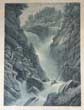
(Code No. 6902)
Burri W. (1802-70).
(antique aquatint print).
La cascade superieure du Reichenbach.--The upper waterfall Reichenbach.
Date. (c.1830}.
Switzerland, Zurich, R. Dirermann. Page size [ 9 1/2 x 11 3/4 ins]. Original aquatint print engraved by J. Hurlimann.taken from an original drawing by W. Burri. .
Showing :-View of the Reichenbach Falls. At the mouth of the Rosenlaui gorges, the meltwater flows towards the valley and forms the Reichenbach, with its falls in seven stages........ £55.00 |
Click on picture above to view more images
How to order |
(Code No. 6900)
Anton Winterlin (1801-1894).
(Antique aquatint print).
La Handeck. Canton of Bern, Guttannen.
Date. (c.1830}.
Switzerland, Basle, Hister & Co. Page size approx [9 1/2 x 11 3/4 ins]. Original aquatint print engraved byTh' Beck.taken from an original drawing by Winterlin..
Showing :- La Handeck Canton Graubunden.. Anton #Winterlin (1801-1894) was a Swiss Architecture and and landscape painter....... £55.00 |
Click on picture above to view more images
How to order |
(Code No.6899)
(antique aquatint print).
F Lose.
Galleria Presso Tusis-Gallery at Tusis.
Date. (c.1830}.
Canton of Bern Guttannen Italy Miliano, F, Brenneea. Page size [ 1/4 x 11 ins].. Original aquatint print engraved by.F Lose taken from an original drawing by .F Lose.:- . . £55.00 |
Click on picture above to view more images
How to order |
(Code No. 6898)
Meye. J.J.
(antique aquatint print).
Vum Innern der drillen im Vallone -- De L'interieur de la troisieme Galerir dans Vallone. Switzerland.
Date. (c.1830}.
Page size [ 1/4 x 11 ins]. Original aquatint print engraved by Karl Bodmer taken from an original drawing by J.J. Meyer.
Showing :- the interior of the third gallery in Vallone is located in Riedikon, Canton of Zurich.. Johann Jakob Meyer engraver and editor, he was a student of H. Fussli and publishes two beautiful collections of engravings. In 1826 he published an album with 32 views of Valchiavennaand and in 1831 he created a series of 36 views of the Valtellina and the eastern Lario...... £55.00 |
Click on picture above to view more images
How to order |
(Code No. 6897)
Meyer, J.J.
(Antique aquatint print).
Galerie des Verlohrnen Loches, von Tusis her danes le Trouperdu,en venant de Tusis Switzerland.
Date. (c.1830}.
Page size [8 1/2 x 11 1/4ins]. Original aquatint print engraved by C. Bordorf taken from an original drawing by J.J. Meyer.
Showing a view of the Buco Perduto tunnel, on the Mala road, taken from the north, in the Canton of Graubünden in Switzerland.. Johann Jakob Meyer (Meilen / CH 1787 - Zurich 1858), engraver and editor, he was a student of H. Fussli and publishes two beautiful collections of engravings. In 1826 he published an album with 32 views of Valchiavennaand and in 1831 he created a series of 36 views of the Valtellina and the eastern Lario....... £55.00 |
Click on picture above to view more images
How to order |
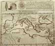
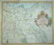
(Code No. 6896).Speed, John (1551- 1629).A New Mappe of the Roman Empire newly described by John Speede and are to be found in pops head alley by G Humble.Date 1626.London. G Humble. Image size [20 x 15 1/2ins]. Original copper engraved framed map by John Speed of the Roman Empire, glazed front and back. 7 very small worm holes. Good margins. Hand-coloured. Not examined outside of frame.While working in London, Speed was a tailor and member of a corresponding guild, and came to the attention of "learned" individuals. These individuals included Sir Fulke Greville, who subsequently made him an allowance to enable him to devote his whole attention to research. By 1598 he had enough patronage to leave his manual labour job and "engage in full-time scholarship." As a reward for his earlier efforts, Queen Elizabeth granted Speed the use of a room in the Custom House. Speed, was, by this point, as "tailor turned scholar" who had a highly developed "pictorial sense".........
|
SOLD.
|
(Code No.6892)
Baedeker, Karl.
Northern France.
Date, 1899, 3rd edition.
Leipzig, Baedeker publisher. 12mo, [4 1/2 x 6 1/2ins] Pp.xxxvi, 424 + 42 of 44 town plans & maps,. Original cloth gilt, very good condition. ..........£25.00 |
Click on picture above to view more images
How to order |
(Code No. 6872)
Anon.
(3 Antique photographs on one leaf, laid on to card).
A Senorita being serenaded + Harbour scene & Garden.
Date. (c.1860).
Spain Image size [6 1/4 x 8ins] & [7 x 4 1/4ins]. 3 Original albumen photographs recto and verso of a senorita being serenaded + harbour scene & garden........ £200.00 |
Click on picture above to view more images
How to order |
(Code No. 6863)
Anon.
(2 Antique photographs on one leaf, laid on to card).
Numbers 7 & 11.
3 Shanish men in a dispute + A Senorita being serenaded.
Date. (c.1860).
Spain Image size [6 1/4 x 8ins]. . 2 Original albumen photographs, recto and verso...... £300.00 |

Click on picture above to view more images
How to order |
(Code No. 6856)
Anon.
(2 Antique photographs on one leaf, laid on to card).
6 Spanish friends outside a house & the exterior of a house.& garden.
Date. (c.1860).
Europe. Images sizes [ 7 1/2 x 9 1/2ins] & [6 x 8ins] 2 Original albumen photograph....... £300.00 |
Click on picture above to view more images
How to order |
(Code No. 6818)
Tallis, John & John Rapkin.
(Antique Map).
Russia in Europe.
Date. (c.1850).
London & New York, J.Tallis. Page size [14 x 10 1/2ins]. Original steel engraved map with outline hand-colouring. Drawn and engraved by John Rapkin. Centre fold. Showing: - 7 Vignette scenes of St. Petersburg, Polish Captives on their way to Siberia, travelling sledge, etc. good condition...... £45.00 |
Click on picture above to view more images
How to order |
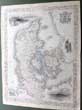
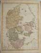
(Code No. 6819)
Tallis, John & John Rapkin.
(Antique Map).
Denmark.
Date. (c.1850).
London & New York, J.Tallis. Page size [14 x 10 1/2ins]. Original steel engraved map with outline hand-colouring. Drawn and engraved by John Rapkin. Centre fold.
Showing: - 6 Vignette scenes, Copenhagen, Sleswig and Elsinore Castle, horses, figures in traditional costume and a coat of arms. very good condition...... £35.00 |
Click on picture above to view more images
How to order |
(Code No. 6814)
Tallis, John & John Rapkin.
(Antique Map).
The Crimea.
Date. (c.1850).
London & New York, J.Tallis. Page size [14 x 10 1/2ins]. Original steel engraved map with outline hand-colouring. Drawn and engraved by John Rapkin. Centre fold. Slight creasing.
Showing: - Vignette scenes of Banks of the Alma, Sevastopol, Balaklava Harbour, Eupatoria by John Rapkin. + Inset map of Sevastopol Harboour, very good condition....... £25.00 |
Click on picture above to view more images
How to order |
(Code No. 6806)
Louis August le Clerc (artist).
Ludovico Magno, "to Louis the Great"."Louis XIV" of France.
(Antique Print).
Date. (c.1750).
France. Page size [10 x 15 ins]. Original copper engraved print, a few edge nicks and some small worm holes.
Louis XIV, or the Sun King, (1638 - 1715), king of France (1643-1715) who ruled his country, principally from his great palace at Versailles, during one of its most brilliant periods and who remains the symbol of absolute monarchy of the classical age. Internationally, in a series of wars between 1667 and 1697, he extended France's eastern borders at the expense of the Habsburgs and then, in the War of the Spanish Succession (1701-14), engaged a hostile European coalition in order to secure the Spanish throne for his grandson. Very rare item......... £65.00 |
Click on picture above to view more images
How to order |
(Code No. 6795).
(Antique Portrait Print).
OSCAR..sveriges och Norges Konung. Crown prince Oscar I Joseph François, of Sweden, 4th July 1799 – 8th July 1859).
No date (c.1830).
Sweden, 74 Gjöthström & Magnusson. Page size [12 x 16ins]. Original lithographic print engraved by Cardon taken from a painting by Joseph Karl Stieler, very good condition.
Oscar I had an excellent education. On January 17th, 1816, he was elected an honorary member of the Royal Swedish Academy of Sciences, and in 1818, he was appointed chancellor of Uppsala University, where he spent one semester. In 1839 he wrote a series of articles on popular education, and (in 1841) he published an anonymous work, Om Straff och straffanstalter, advocating prison reforms. Twice during his father's lifetime he was viceroy of Norway. By proxy at the Leuchtenberg Palace in Munich on 22nd May 1823 and in person at a wedding ceremony conducted in Stockholm on 19th June 1823 he married the Princess Josephine, daughter of Eugène de Beauharnais, Duke of Leuchtenberg, and granddaughter of the Empress Josephine..........£90.00 |
Click on picture above to view more images
How to order |
(Code No. 6793)
Anon.
(2 Antique photographs on one leaf, laid on to card).
Number 15.
3 Spanish ladies seated outside a house + An unknown harbour view.
Date. (c1860).
Europe. Image sizes [6 3/4 x 8ins] & [6 x 8ins]. 2 Original albumen photographs recto and verso of 3 Spanish ladies seated outside a house with unclear lettering on a notice board + an unknown harbour view showing cannons etc....... £420.00 |
Click on picture above to view more images
How to order |
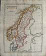
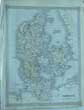
(Code No. 6791)
Bevan, G. Phillips.
(Antique Map).
Relief Map of SCANDINAVIA.
Date. [c.1885].
London. Swan, Sonnenschein & Allan. Page size, approx [12 x 11 ins.] A coloured map with accompanying text, embossed to show physical geography in 3 dimensions, very good condition .....£35.00 |
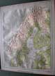
Click on picture above to view more images
How to order |
(Code No. 6772)
Hayward, Richard.
The Corrib Country, Dundalk.
Date. 1968.
W. Tempest Dundalgan Press, 8vo, [6 x 9ins] . Pp. 164 + illustrations throughout + Map in rear pocket. Owner's name on front past down. Original cloth gilt, very good condition. Dust jacket, slight nicks to outer edges...... £25.00 |
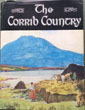
Click on picture above to view more images
How to order |
(Code No. 6768)
Bowyer, R.
Smolensko. (Antique print}.
Date.1814.
London, R. Bowyer. Page size [ 19 x 13ins]. Image size [12 1/2 x 9 ins]. Pp. 4 + Original hand-coloured aquatint print of Smolensk, slight nicks to outer edges.
Smolensk is a city in the West of Russian, located along the Dnieper River, and is the administrative centre of Smolensk Oblast. Showing a panorama of Smolensk with the Dnieper River, medieval city walls and a group of peasant women in traditional dress is shown in the foreground. From Smolensko Napoleon marched upon Moscow, at the head of 160,000 men......... £110.00
|
Click on picture above to view more images
How to order |
(Code No. 6753)
Owen, Collinson. Harry.
Salonica and after the sideshow that ended the war.
Date. 1919.
London: Hodder and Stoughton. [4to, 6 x 9ins]. Pp. viii, 295 + Illustrations throughout + end paper map + a hand written note of a Noel Platt's fallen pals. Original cloth gilt.
In October 1915 a combined Franco-British force of some two large brigades was landed at Salonica (today called Thessalonika) at the request of the Greek Prime Minister. The objective was to help the Serbs in their fight against Bulgarian aggression. But the expedition arrived too late, the Serbs having been beaten before they landed. It was decided to keep the force in place for future operations, even against Greek opposition. The Greek Chief of the General Staff in Athens had told them "You will be driven into the sea, and you will not have time even to cry for mercy" (Some Greek factions, including King Constantine, were pro-German)...... £50.00 |
Click on picture above to view more images
How to order |
(Code No, 6750)
Hayward, Richard.
This is Ireland CONNACHT and the City of Galway.
Date. 1952, 1st edition.
London, Arthur Barker Limited. 4to, [6 x 9ins]. Pp. 192. + Illustrations throughout. Original printed cloth. Dust Jacket, very good condition. ......£35.00 |
Click on picture above to view more images
How to order |
(Code No. 6746)
Sharrock. J.T.R
The Natural History of Cape Clear Island.
Date. 1973, 1st .
Berkhamstead. D. Poyser Ltd. 8vo [6 x 9ins]. edn. Pp 207,vg. Illustrated with photographs and diagrams etc.Owner's signature on past down. Original cloth gilt. D/j, 2 minor nicks, (3mm), vg..... £50.00 |
Click on picture above to view more images
How to order |
(Code No. 6740)
Bevan, G. Phillips.
(Antique Map).
Relief Map of FRANCE.
Date. [c.1885].
London. Swan, Sonnenschein & Allan. Page size, approx [12 x 11 ins.] . A coloured map with accompanying text, embossed to show physical geography in 3 dimensions, very good condition ........£30.00 |
Click on picture above to view more images
How to order |
(Code No. 6737)
Bevan, G. Phillips.
(Antique Map).
Relief Map of DENMARK including inset maps of (Iceland & Faroe Islands).
Date. [c.1885].
London. Swan, Sonnenschein & Allan. Page size, approx [12 x 11 ins.] A coloured map with accompanying text, embossed to show physical geography in 3 dimensions, very good condition........ £55.00 |
Click on picture above to view more images
How to order |
(Code No. 6735)
Bevan, G. Phillips.
(Antique Map).
Relief Map of GERMANY.
Date. [c.1885].
London. Swan, Sonnenschein & Allan. Page size, approx [12 x 11 ins.] A coloured map with accompanying text, embossed to show physical geography in 3 dimensions, very good condition...... £35.00 |
Click on picture above to view more images
How to order |
(Code No. 6730)
LIZARS, WILLIAM. HOME, (1788-1859).
(Antique Map).
Bavaria. Proper.
Date. [c.1846]
Edinburgh, W. H. Lizars. Page size [22 x 18 1/2ins]. Image size 20 x 16 1/2ins].Original outline hand coloured steel engraved double page engraved map, nicks to blank margins, well clear of engraved map surface and centre fold split, repaired........ £30.00 |
Click on picture above to view more images
How to order |
(Code No. 6729)
LIZARS, WILLIAM. HOME, (1788-1859).
(Antique Map).
Germany. Austrian Dominion.
Date. [c.1846].
Edinburgh, W. H. Lizars. Page size [22 x 18 1/2ins]. Image size 20 x 16 1/2ins]. Original outline hand coloured steel engraved double page engraved map, nicks to blank margins, well clear of engraved map surface and centre fold split, repaired....... £30.00 |
Click on picture above to view more images
How to order |
(Code No. 6728)
LIZARS, WILLIAM. HOME, (1788-1859).
(Antique Map).
Swabia.
Date. [c.1846].
Edinburgh, W. H. Lizars. Page size [22 x 18 1/2ins]. Image size 20 x 16 1/2ins].Original outline hand coloured steel engraved double page engraved map, nicks to blank margins, well clear of engraved map surface and centre fold split, repaired...... £30.00 |
Click on picture above to view more images
How to order |
(Code No. 6727)
LIZARS, WILLIAM. HOME, (1788-1859).
(Antique Map).
Lower Saxony.
Date. .[c.1846].
Edinburgh, W. H. Lizars. Page size [22 x 18 1/2ins]. Image size 20 x 16 1/2ins]Original outline hand coloured steel engraved double page engraved map, nicks to blank margins, well clear of engraved map surface....... £30.00 |
Click on picture above to view more images
How to order |
(Code No. 6726)
LIZARS, WILLIAM. HOME, (1788-1859).
(Antique Map).
Upper Saxony, partly belonging to Prussia.
Date. [c.1846].
Edinburgh, W. H. Lizars. Page size [22 x 18 1/2ins]. Image size 20 x 16 1/2ins].Original outline hand coloured steel engraved double page engraved map, nicks to blank margins, well clear of engraved map surface. slight browning to bottom right blank corner...... £40.00 |
Click on picture above to view more images
How to order |
|
(Code No. 6703)
Bevan, G. Phillips.
(Antique Map).
Relief Map of NETHERLANDS & BELGIUM.
Date. [c.1885].
London. Swan, Sonnenschein & Allan. Page size, approx [12 x 11 ins.] . A coloured map embossed to show physical geography in 3 dimensions, very good condition..... £40.00
|
Click on picture above to view more images
How to order |
|
(Code No. 6701)
Bevan, G. Phillips.
(Antique Map).
Relief Map of ITALY.
Date. [c.1885].
London. Swan, Sonnenschein & Allan. Page size, approx [12 x 11 ins.] A coloured map embossed to show physical geography in 3 dimensions, very good condition........ £40.00
|
Click on picture above to view more images
How to order |
|
(Code No. 6665)
Williams, H. David.
The Cistercians in the Early Middle Ages: Written to Commemorate the Nine Hundredth Anniversary of Foundation of the Order at Citeaux in 1098. Under the Patronage of Blessed Vincent Kadlubek .
1998.
Herefordshire, Leominster, Gracewing. 4to, [12 x 9ins]. Pp. x, 479 + 35 Photographs + Maps and plans. Original cloth gilt, very good condition. Dust jacket, very good condition.
Cîteaux Abbey was founded on Saint Benedict's Day, 21 March 1098, by a group of monks from Molesme Abbey seeking to follow more closely the Rule of St. Benedict. They were led by Saint Robert of Molesme, who became the first abbot. The site was wooded and swampy, in a sparsely populated area. Heavy book........ £35.00
|
Click on picture above to view more images
How to order |
|
(Code No. 6606)Raze, L.L.(Antique Print).At La Cava Provance of Naples.Date. 1869.London. Lechertier Barbe & Co. Page size, [16 x 11ins]. Original lithograph.Raze's Easy Studies. nick & dust marks to outer margins not affecting engraved image......
|
SOLD.
|
|
(Code No. 6605)
Raze, L.L.
(Antique Print).
Santa Balbina, Rome.
Date. 1869.
London. Lechertier Barbe & Co. Page size, [15 1/4 x 11ins]. Original lithograph,.Raze's Easy Studies. crease marks & dust marks to outer margins not affecting engraved image....... £35.00
|
Click on picture above to view more images
How to order |
|
(Code No. 6604)
Raze, L.L.
(Antique Print).
Torre di Quinto on the Tiber near Rome.
Date. 1869.
London. Lechertier Barbe & Co. Page size, [16x 11ins]. Original lithograph,.Raze's Easy Studies. nicks & dust marks to outer margins not affecting engraved image...... £35.00
|
Click on picture above to view more images
How to order |
|
(Code No. 6603)
Raze, L.L.
(Antique Print).
Near Forio in the Isle of Ischia with Caruso point and the Isle of Ponza in the distance.
Date. 1869.
Paris, Lemercier & Co. Page size, [19 1/4 x 13ins]. Original lithograph, nicks & dust marks to outer margins not affecting engraved image. ......£50.00
|
Click on picture above to view more images
How to order |
|
(Code no. 6552)Le Roy.Tsar Peter the Great of Russia.(Antique Print).Date. 1717.Paris. Page size, (10 x 13 1/4ins). Original copper engraved portrait by I. F. Bause.Tsar Peter I of Russia is more usually described as 'Peter the Great'. As a young man, he travelled to Europe in 1697–98 to study new developments in technology, especially shipbuilding. He lived in Deptford, at the home of the writer John Evelyn, for much of his four-month stay in England.......
|
SOLD.
|
|
(Code No. 6551)
Taylor, C.
(Antique Map).
Map of EUROPE.
Date. November 1st, 1814.
London, Published by C. Taylor. Page size, [10 1/4 x 8 1/2ins]. Original copper engraved map by C.Taylor, slight marks...... £30.00
|
Click on picture above to view more images
How to order |
|
(Code No. 6447)Brangwyn, Frank & Hugh, Stokes.BELGIUM.Date. 1916. London, Kegan Paul, Trench, Trubner and Co. Ltd. 4to, [9 1/2 x 12 1/2ins]. Pp. xvi,144 + 52 Engraved prints, very good condition. Original decorated cloth, rubbed ...Sir Frank William Brangwyn RA (1867 – 1956) was an Anglo-Welsh artist, painter, water colourist, engraver and illustrator, and progressive designer...Brangwyn produced more than 80 poster designs during the First World War, he was not an official war artist.. His grim poster of a Tommy bayoneting an enemy soldier (“Put Strength in the Final Blow: Buy War Bonds”) caused deep offence in both Britain and Germany............
|
SOLD.
|
|
(Code No. 6400)Gromort, G. Choix de plans de Grandes Compositions Exécutées présentant, avec leurs Jardins ou leur entourage. Une série d'ensembles de l'antiquité, de la Renaissance et des temps modernes. 29 Planches d'après les Dessins et relevés .Date. 1910.Paris. Auguste Vincent. Folio, [17 1/4 x 12ins]. Pp. 20, (French Text) + 29 plates. Original printed boards, marked. With ties.Choice of plans with Great Compositions Executed with their gardens or their surroundings. A series of sets of antiquity, the Renaissance and modern times. 29 Plates based on drawings and records. Gardens shown:- Versailles, Marly, Chateau de Caserth, Villa D'Este a Tivoli, L' Isola Bella du Lac Majeur, etc........
|
SOLD.
|
|
(Code No. 6390)
KENNETT, Basil.
Romae Anitque Notitia: or the Antiquities of Rome. In two parts.
A short history of the rise, progress, and decay of the Commonwealth & A description of the City: an anccount of the religion, civil goverment, and art of War.....
Date. 1793.
London, T. Longman & others. 8vo, [5 1/2 x 8 1/2ins]. Pp. xxx, 375, [26] + 13 copper engraved prints some folding, Lacks portrait & part of title.. Original full calf, rubbed & boards just holding...
KENNETT, BASIL (1674-1715), miscellaneous writer, born at Postling, Kent, on 21 Oct. 1674, was younger brother of White Kennett, bishop of Peterborough, He was educated under the care of his brother at Bicester grammar. In 1689 he entered St. Edmund Hall, Oxford, under the tuition of his brother, who was then vice-principal. His learning and amiable qualities won him the regard of all parties. In 1706 he was appointed chaplain to the British factory at Leghorn, being the first to fill that office. He was at first much harassed by the Inquisition, and had to seek the intervention of the English government. Bad health, caused by the climate and his dislike of exercise, obliged him to resign, and he preached for the last time on 8 Jan. 1712-13. He returned home by way of Florence, Rome, and Naples, and through France, collecting books, sculpture, and curiosities. He resumed residence at Corpus Christi in 1714, became D.D., and during the same year was elected president of his college, He died on 3 Jan. 1714-15 and was buried in the college chapel........ £60.00
|
Click on picture above to view more images
How to order |
|
(Code No. 6368)
Maenza, P.
Environs de BOULOGNE sur-Mer. Boulogne.
Date. [c.1830].
Folio, [19 1/2 x 14ins]. 6 Lithographic engraved prints by Le Roy-Mabille very good condition. Original decorated printed boards, marked with surface loss........ £60.00
|
Click on picture above to view more images
How to order |
|
(Code No. 6354)
PUGIN, A. W.
Volume 3. (Plate volume only).
Types of Gothic Architecture borrowed the most remarkable buildings built in England during the XII, XIII, XIV, XV and XVI centuries and represented in drawings, elevations, sections and details geometraux in order to complete the study.
Date. [c.1850].
Liege, Paris. E. Noblet and Borrani & Droz. 4to, [10 x 13 1/4ins]. 75 of 76 Steel engraved prints + (1), edge nicks and creases, not affecting images. French print titles. Printed soft covers, marginal nicks....... £70.00
|
Click on picture above to view more images
How to order |
|
(Code No. 6344)
Murphy, W.
(Antique Map).
EUROPE..
Date. 1828.
Ebinburgh, Oliver & Boyd. Page size [9 x 7 1/2ins]. Original folding engraved map of the Europe... £25.00
|
Click on picture above to view more images
How to order |
|
(Code No. 6341)
WYL, A. V.
Rosen des Lebens. Unverwelkliche Bluten fur Geist und Herz. Ausgewahlt aus deutschen Dichtern -
Date. 1898.
Nurnberg, Th Stroefer. 4to, Pp. 160. including 5 coloured botanical plates and 10 full page plates by F. Hines, A. Seifert, E. Nister. German text. Flowers for mind and heart. Selected from German poets. Gilt decorated cloth, slight rubbing. gilt edges...... £30.00
|
Click on picture above to view more images
How to order |
|
(Code No. 6331)
Bowyer, R.
Smolensko.
(Antique print}.
Date. 1814.
London, R. Bowyer. Page size [ 16 x 11/2ins]. Image size [12 1/2 x 9 ins]. Original hand-coloured aquatint print.
Smolensk is a city in the West of Russian, located along the Dnieper River, and is the administrative centre of Smolensk Oblast. Showing a panorama of Smolensk with the Dnieper River, medieval city walls and a group of peasant women in traditional dress is shown in the foreground. From Smolensko Napoleon marched upon Moscow, at the head of 160,000 men...... £110.00
|
Click on picture above to view more images
How to order |
|
(Code No. 6330)
Cole, B.
(2 Antique maps on one page).
European Colonies in America & The Navigation of the North.
Date. 1760.
London: Stanley Crowder. Page size [7 x 8ins]. Original copper engraved folding map of the European Colonies in America & The Navigation of the North, very good condition.... £60.00.
|
Click on picture above to view more images
How to order |
|
(Code No. 6317)
Cole, B.
The Mediterranean Course..
(Antique Map).
Date. 1760.
London: Stanley Crowder. Page size [8 x 7ins]. Original copper engraved folding map of the The Mediterranean Course.., very good condition .....£40.00
|
Click on picture above to view more images
How to order |
|
(Code No. 6314)Beattie, William.SWITZERLAND. Illustrated in a series of views taken expressly for this work by W.H. Bartlett, Esq.(2 Volumes).Date. 1836-37.London: George Virtue, 4to, [9 x 11 1/2ins]. Pp. iv , 186. 152. + 2 engraved titles + 106 Steel engraved plates, a few plates with foxing spots, mostly marginal + Folding map, very good.. Full cloth gilt, faded spine.....
|
SOLD.
|
|
(Code No. 6286)
Pascal , M. J. L.
Concovrs Rovgevin & Godeboevf.
(French internal and exterior neoclassical architectural building designs).
Date. [c.1909].
Paris, Auguste Vincent. Folio Pp. [vi], 16, some text with brown marks + 166 photo type architectural prints, very good condition. All text and prints loose, as issued. Marbled boards with ties, lacks part of spine cloth. Heavy book....... £90.00
|
Click on picture above to view more images
How to order |
|
(Code No. 6273)
Underwood & Underwood.
ITALY. THROUGH THE STEREOSCOPE.
Date. [c.1890].
New York, London. Underwood & Underwood. 8vo, [7 1/2 x 6 1/2ins]. 98 of 100 Stereographs in the original publisher's cloth slipcase, slight marks. A stereoscope is a device for viewing a stereoscopic pair of separate images, depicting left-eye and right-eye views of the same scene, as a single three-dimensional image...... £150.00
|
Click on picture above to view more images
How to order |
|
(Code No. 6265)Desgodetz, Antoine & Mr. Charles Taylor.Rome in its ancient grandeur : displayed in a series of engravings presenting the architectural antiquities of the imperial city / accurately measured and delineated on the spot by Antoine Desgodetz.Date. 1848.London, Sherwood, Gilbert and Piper. Folio, [10 1/2 x 14ins] 142 Engraved full page and folding engraved architectural plates, with descriptive text, slight marks. Disbound.Antoine Desgodetz's (1653-1728) publication provided detailed engravings of the monuments and antiquities of Rome. Desgodetz had been sent to Rome in an official capacity, part of French architectural and artistic policy, The young architect with a copy of Les edifices antiques de Rome could determine the precise proportions of many Roman structures, such as the portico of the Pantheon, or the Temple of Vesta, Tivoli, that were considered the best models, a practice that had the effect of standardizing the details of academic architecture. The young Robert Adam toyed with the idea of producing a revised version of Desgodetz......
|
SOLD.
|
|
(Code No. 6248)
Anon.
(Antique Print).
Date 1643, or later reprint.
Paris, St Andre des Arts, Porte de Buoy. Page size [25 1/2 x 21 1/2ins]. Image size 21 1/2 x 15 1/2 ins]. Beautiful hand-coloured engraved print, Margins water stained and browned. Image, very good.
Showing:- Taking three vessels very close to Tetouan la coste de Barbarie by the naval forces of King very Christian King Louis XIV commissioned by Mr Duke Breze. December 1643..... £80.00
|
Click on picture above to view more images
How to order |
|
(Code No. 6226)
Weller, W.
Map of the Environs of DUBLIN & Map of the Environs of CORK.
(2 Irish Antique Town Plans).
Date. [c.1875].
London, (George Philip and Son). Page sizes, (approx), [20 x 13ins]. Date. 2 Original engraved Town Plans with hand-colour. Scale, (approx), 2 1/2 inchs to the Mile...... £40.00
|
Click on picture above to view more images
How to order |
|
(Code No. 6196)
HAVARD Henry.
L'art dans la Maison. Grammaire de l'ameublement.
(Art in the House. Furniture styles).
Date. 1884.
Paris, Rouveyre Et G. Blond, Folio, [9 x 12 1/4ins]. Pp. x, 472 + 52 Coloured & black and white plates. French text.
Showing: - French style buffets and sideboards, wallpaper, cabinet, chairs, beds, mirrors, fireplaces, vases, etc. Original half morocco. Raised spine bands with gilt decorated panels, rubbed and chipping....... £75.00
|
Click on picture above to view more images
How to order |
|
(Code No. 6134)
Cowley, John.
A Map of Spain and Portugal. By J. Cowley. Geor. Royal.
Date. 1777.
London, J. Buckland..Image size, [5 x 4 1/4ins]. Original hand-coloured, (modern colouring), copper engraved map, taken from "A New and Easy Introduction to the Study of Geography", very good condition.......... £50.00.
|
Click on picture above to view more images
How to order |
|
(Code No. 6128)Rabbe, Alphonse and Jonathan Duncan.2 volumes.History of Russia from the Foundation of the Empire by Rourick to the close of the Hungarian War.Date. 1854.London, Herbert Ingram and Co. 8vo, [5 1/4 x 8ins]. Pp. viii, 286, 314 [8 adverts] + 2 folding maps + 2 engraved vignette titles + 14 two tone lithographic view prints, rich impression, (as listed), very good condition. Original blind stamped cloth gilt, slight fading to spine....
|
SOLD.
|
|
(Code No. 6127)
BAINES, Edward [1774-1848].
2 Volumes bound up in 1.
History of the Wars of the French Revolution, from the Breaking out of the War In 1792, to the Restoration of a General Peace In 1815, Comprehending the Civil History of Great Britain and France, During that Period.
Date. 1817.
London, Printed for Longman, Hurst, Rees. 4to, [8 1/2 x 10 1/2ins]. Pp. 539, 595 + 33 engraved plates including, 15 copper engraved portraits + 12 engraved maps, 4 folding by J. Neele. Original full reverse calf gilt, leather hinges split. Holding firm....... £120.00
|
Click on picture above to view more images
How to order |
|
(Code No. 6117)
Nolan, E.H. .....
2 Volumes, (complete).
The Illustrated History of the War against Russia.
Date. [c.1857].
London, James S. Virtue. 8vo, [ 7 x 10ins]. Pp. viii, 812, viii, 772, slight foxing + 7 Engraved coloured maps + 65 Steel engraved views & portraits, slight foxing. Original half calf. Raised spine bands gilt with embossed decorated panels, spine chipped at base & rubbed....
The Crimean (1853 -1856) was a conflict between the Russian Empire and an alliance of the French Empire, the British Empire, the Ottoman Empire, and the Kingdom of Sardinia. The war was part of a long-running contest between major European powers for influence over territories of the declining Ottoman Empire. Most of the conflict took place on the Crimean peninsula, but there were smaller campaigns in eastern Anatolia, Caucasus, the Baltic Sea, the Pacific Ocean and the White Sea........ £160.00
|
Click on picture above to view more images
How to order |
|
(Code No. 6108)
Koenig, F. Lory, und Anderen.
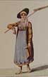
Nouvelle Collection de Costumes Suisses des XXII Cantons.......
Date. 1980, reprint of the 1820 edn.
Zürich: Neue Zürcher Zeitung. 8vo. Pp. 210, [1]. Text in French and German + 49 Beautiful coloured Swiss costume plates. Original gilt style full leather boards. Gilt edges. Fine copy...... £30.00
|
Click on picture above to view more images
How to order |
|
(Code No. 6091)Jungman, Nico.Norway.Date. 1905.London: A. and C. Black. 8vo, [7 x 9ins]. Pp. x 199, slight foxing + 75 Colour plates with tissue guards. Original gilt decorated cloth, very good condition. Gilt top edge.Nicolaas Wilhelm Jungmann (1872 – 1935) was an Anglo-Dutch painter of landscapes and figural subjects, a book-illustrator and decorator. Jungmann made several painting excursions to Brittany and Holland with his friend and fellow-painter Charles W. Bartlett. He illustrated topographical books on Holland (1904) and Norway (1905) for which his wife Beatrix wrote the text, as well as one on Normandy (1905) with a text by Geraldine Edith Mitton. He died, aged 63, in London.......
|
SOLD.
|
|
(Code No. 6061)
Tindal, Nicolas.1687-1774.
(Antique Print).
Aeth, (Belgium), a Strong Frontier Town in Brabant, taken by the Duke of Marlborough in 1706.
Date. [c.1730].
London, John and Paul Knapton. Page size, approx [19 1/2 x 16ins]. Image size, approx [18 1/4 x 14ins]. Original hand-coloured copper engraved plan by J Basire, (modern colouring).
The Duke of Marlborough's ten consecutive campaigns during the Spanish Succession war Marlborough held together a discordant coalition through his sheer force of personality and raised the standing of British arms to a level not known since the Middle Ages. his victories allowed Britain to rise from a minor to a major power, ensuring the Britain's growing prosperity throughout the 18th century...... £35.00
|
Click on picture above to view more images
How to order |
|
(Code No. 5945)Stockdale, J.(Antique Map)Map of Portugal.Date 1809. London, J. J. Stockdale. Page size, [10 1/2 x 15 1/2ins].14th July 1809. Copper engraved map by with outline hand-colour. Engraved by S, Neele. Cross compass indicator. Separate line scale and title. Slight nick to margin not affecting engraved area.....
|
SOLD.
|
|
(Code No. 5928)Braun, Georg (1541-1590) & Frans Hogenberg (1535-1590).HUY. (Belgium).Hvvm surface. condrvsorvm capvt.Date. 1575 - 1617.Cologne. Image size, [18 1/4 x 12ins]. Copper engraving from the Civitates Orbis Terrarum by Braun and Hogenberg. Laid down onto card..Huy (French; Dutch: Hoei; Walloon: Hu) is a municipality of Belgium. It lies in the country's Walloon Region and Province of Liege. Huy lies along the river Meuse, at the mouth of the small river Hoyoux. It is in the sillon industriel, the former industrial backbone of Wallonia, home to about two-thirds of the Walloon population. The Huy municipality includes the old communes of Ben-Ahin and Tihange......
|
SOLD.
|
|
(Code No. 5918)
Tallis, John.
[Antique Map.]
IRELAND.
Date. [c.1850].
London. J & F Tallis. Page size, (approx), [15 x 10 1/2ins]. Original steel engraved map with original outline hand colouring. 5 vignette views. Decorated border, centre fold, marked & slight nicks to outer edges, not affecting engraved image.
John Tallis' maps are the last decorative, regional maps to be published....... £80.00
|
Click on picture above to view more images
How to order |
|
(Code No. 5875)
Daudet, Alphonse.
Translated by Henry Frith.
Tartarin on the Alps.
Date. 1896, 1st edn.
London. J. M. Dent. 8vo, Pp. [6], 365 + Illustrations throughout, very good. Edges uncut. Original decorated cloth, slight marks...... £50.00
|
Click on picture above to view more images
How to order |
|
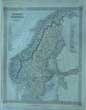
(Code No. 5861)
Bell, James, & Fullarton.
(Antique Map).
Sweden & Norway.
Date. 1835.
Glasgow. A, Fullarton & Co. Original steel engraved folding map by Gray & Son.With an steel engraved vignette view of "Great Mine at Falun"..... £40.00
|
Click on picture above to view more images
How to order |
|
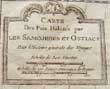
(Code No. 5860)
Bellin, Jacques Nicholas.
(Antique Map).
Carte Des Pais Habites par Les Samojedes Et Ostiacs.
(Artic Sea, Archangel, Russia).
Date. 1757.
Paris, Image size, (approx), [9 x 9ins]. Original copper engraved folding map taken from Prevost L'Histoire Generale des Voyages.
Bellin was born in Paris. He was hydrographer of France's hydrographic office, member of the Académie de Marine and of the Royal Society of London. Over a 50 year career, he produced a large number of maps of particular interest to the Ministère de la Marine. His maps of Canada and of French territories in North America (New France, Acadia, Louisiana) are particularly valuable. He died at Versailles...... £35.00
|
Click on picture above to view more images
How to order |
|
(Code No. 5804)Bartlett, W. H & Julia. Pardoe.The Bosphorus and the Danube.Division 6 only of 8.Date. [c.1850].London, Virtue. 4to, [11 x 8 1/2ins]. Pp. 39-86 + 23 Steel engraved prints, foxing spots. Original cloth gilt, lacks part of spine cloth.Julia Pardoe is best known for her books on her travels in Turkey, which are some of the earliest works by a woman on this area. In 1836 she travelled to Constantinople with her father, Major Thomas Pardoe. This voyage inspired her book The City of the Sultan (1836). Later she collaborated with the artist William Henry Bartlett to produce The Beauties of the Bosphorus (1839), an illustrated account of Constantinople. ...
|
SOLD.
|
|
(Code No. 5791)
Hornsby, M.
The Queen Newspaper Book of Travel -
Guide to Home and Foreign Resorts.
Date. 1911.
London; Horace Cox, 8vo, [4 1/2 x 7 1/4ins]. Pp. x, 570 + 18 maps, (as listed), Welsh map nicks to edges, no loss. Original printed boards....... £35.00
|
Click on picture above to view more images
How to order |
|
(Code No. 5687)
D'HERISSON, M. LE COMTE.
JOURNAL OF A STAFF OFFICER IN PARIS DURING THE EVENTS OF 1870 AND 1871.
Date. 1885
London: Remington. 8vo, [6 x 9ins]. Pp 332. Ink dedication in blank margin of title page. Original embossed cloth boards, Gilt lettering on spine. Top and bottom of spine rubbed..... £40.00
|
Click on picture above to view more images
How to order |
|
(Code No. 5682)
Anon.
Ricordo di Roma.
(Part 1).
Date. [c,1900].
Rome. 8vo, [5 x 6 3/4ins].. 32 coloured photographs opening in a concertina-style, with Italian and English text. Original decorated boards, slight rubbing...... £45.00
|
Click on picture above to view more images
How to order |
|
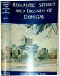
(Code No. 5616)
Swan, Harry Percival.
Romantic stories and legends of Donegal by H. P. Swan.
Date. 1965.
Belfast, H. R. Carter Publications. 8vo, [6 x 9ins.] Pp. xv. 275, [4] + Illustrations throughout.
Lists:- Customs, superstitions, legends, folklore, topogography, ornithology, songs, poetry and ballads, etc. Original cloth gilt, slight marks. Dust jacket, marginal nicks...... £70.00
|
Click on picture above to view more images
How to order |
|
(Code No. 5615)
SHAW, Richard.
Norman. Architectural sketches from the Continent.
Date. 1872.
London, Day & Son, lithographers to the Queen. Folio, [11 1/2 x 15ins.] Pp. [14] + 100 Architectural sketches taken from the original drawings by R.N.Shaw, slight foxing. Original cloth gilt, lacks the original spine cloth. Holding firm. Gilt edges.
Richard Norman Shaw RA ( 1831 – 1912), was an influential British architect from the 1870s to the 1900s, known for his country houses and for commercial buildings. Shaw trained in the London office of William Burn with George Edmund Street and attended the Royal Academy classes, receiving a thorough grounding in classicism, and met William Eden Nesfield, with whom he was briefly in partnership. In 1854 – 1856 he travelled with a Royal Academy scholarship, collecting sketches that were published as "Architectural Sketches from the Continent", 1858. ......£120.00
|
Click on picture above to view more images
How to order |
|
(Code No. 5607)Plan Monumental Paris & Environs Nouveau Paris Monumental.(Front & Back of Single Sheet).Date. [c.1900].Paris. J. Leconte. Page size 22 x 30 ins. Folding to 6 1/4 x 4 1/4 ins. Pp 12. (Text in English, French and German). One side of folding coloured map shows many vignettes of Churches, Houses, Monuments etc, the opposite side of map shows many vignettes of Modern Paris. Listing:- Electrical transport, Eiffel Tower, Observatory etc. Red covers with gilt decoration, slight nicks to edges....
|
SOLD.
|
|
(Code No. 5585)Bingley, William. Revd.Travels in Europe. from Modern writers, with Remarks and Observations; Exhibiting a Connected View of The Geography and Present State of that Division of the Globe.Date. 1821.London. Harvey & Darton. 8vo, [7 x 4 1/2 ins]. Pp 1- 360 Text + Engraved frontis views + Engraved title + Advert + (8) index + 12 Copper engraved views on 4 full pages. Tours through:- France, including Paris and environs, Paris to Orleans, Orleans to Aix, Switzerland, Italy, Trent to Venice, Venice to Rome, Rome and environs, Naples, Greece, Athens and environs, Constantinople, Madrid, Valencia and Portugal. Original full calf gilt, rubbed & slight split to the leather ....
|
SOLD.
|
|
(Code No. 5581)
Hall, S.
Sweden.
(Antique map).
Date. 1823.
London. Longman...Image size [9 1/2 x 7 ins]. . Original copper engraved and drawn map by S, Hall. With original outline hand colouring. ....£35.00
|
Click on picture above to view more images
How to order |
|
(Code No. 5568)
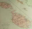
(Antique Map.)
Arrowsmith, John.
Map of the Ionian Islands and Malta Compiled from Surveys & Original Documents in the Colonial Office, the Ordnance Department &c.
Date. [c.1887].
London, Edward Stanford. Page size [26 1/4 x 22 1/4ins]. Original colour printed map, very good condition..... £120.00
|
Click on picture above to view more images
How to order |
|
(Code No. 5509)Alain-René Lesage (1668 – 1747; older spelling Le Sage).Histoire de Gil Blas de santillane par Le Sage, vignettes par Jean Gigoux.Date. 1836.Paris, Chez Paulin. 4to, [7 x 10ins.] Pp. 972, (French text), very good condition + Many woodcut plates by Jean Gigoux, very good condition. Original full calf with gilt roll frame. Raised spine bands with gilt decorated panels, very slight rubbing. Marbled edges and end papers. Fine copy....
|
SOLD.
|
|
(Code No. 5453)
Leger, Hidalgo, F.
La Casa de Pilatos, Seville. Spanish.
Date. [c.1920].
Frame size [13 x 15 1/2ins]. Image size [7 x 9ins]. Contemporary frame and mount, by the Army & Navy Co-operative Society, Ltd. (Fine Art Section). Signed watercolour "F. Leger", Seville, (lower right). The Mount is marked & waterstained.
La Casa de Pilatos (Pilate's House) is an Andalusian palace in Seville, Spain, which serves as the permanent residence of the Dukes of Medinaceli. The building is a mixture of Renaissance Italian and Mudéjar Spanish styles....£400.00
|

Click on picture above to view more images
How to order |
|
(Code No. 5452)Billmark , Carl Johan. (1804 - 1870).Gripsholm Castle, west of Stockholm.Date. [c.1853]Paris. Lemercier. Folio, [16 x 22ins]. (approx), Image sizes (13 x 10ins). 12 Coloured lithographic plates of Gripsholm Castle, interior & exterior views, one minute worm hole penetrating throughout. Decorated printed boards, marked.Gripsholm Castle (Swedish: Gripsholms slott, Mariefred) is a castle in Mariefred, Södermanland, in Sweden and is regarded as one of Sweden's finest historical monuments. It is located by lake Mälaren in south central Sweden, in the municipality of Strängnäs...
|
SOLD.
|
|
(Code No. 5449)
The History of Spain, from the first settlements of the colony of Gades by the Phoenicians.......Death of Philip 2nd.
2 Volumes, (complete).
Date. 1814.
London, J. Goodwin. 8vo, [5 1/2 x 8 1/2ins]. Pp. 449, 483 + Folding hand-coloured copper engraved map of Europe. Original full calf gilt. Marbled edges.The most ancient Phoenician colonies were Utica, nearly on the northern most point of the coast of Africa, and in the same gulf, (now known as the Gulf of Tunis) as Carthage, over to Cape Lilybaeum in Sicily, - and Gades, or Gadeira, now Cadiz on the south-western coast of Spain. No other edition of this work found. Very rare..... £130.00
|
Click on picture above to view more images
How to order |
|
(Code No. 5430)
A Picturesque Tour through France,Switzerland, on the Banks of the Rhine, and throught part of The Netherlands in the year 1816.
Date. 1817.
London. J, Mawman. 4to [6 1/2 x 9 1/2ins] Pp xiii 379. 4 Full page route maps. Map list, Calais - Moulins. Moulins - Geneva. Geneva - Heydelberg. Heydelberg - Calais, foxing spots. Original trade boards, spine chipped.... £80.00
|
Click on picture above to view more images
How to order |
|
(Code No. 5355)
Finlay. A.
(Antique Map.)
Denmark.
Date. [c.1817.]
London, Thomas Kelly. Page size [10 3/4 x 8 1/2ins.] Image size [7 3/4 x 9 1/4ins.]. Original hand-coloured steel engraved map, very good... £45.00
|
Click on picture above to view more images
How to order |
|
(Code No. 5354)
Kelly, Thomas.
(Antique Map.)
Sweden and Norway.
Date. [c.1817.]
London, Thomas Kelly. Page size [10 3/4 x 8 1/2ins.] Image size [7 3/4 x 9 1/4ins.]. Original hand-coloured steel engraved map by A. Finlay, very good... £45.00
|
Click on picture above to view more images
How to order |
|
(Code No. 5353)
Wilkinson, J.
(Antique Map.)
A New Map of Denmark and Holstein.
Date. 21st April 1794.
London, J. Wilkinson. Page size 10 x 13ins. Image size [9 x 11 1/4ins.] Original hand-coloured copper engraved map by W. Harrison, very good... £70.00
|
Click on picture above to view more images
How to order |
|
(Code No. 5352)
Bowen. Thomas.
(Antique Map.)
An accurate Map of Sweden and Denmark and Norway, from the best authorities by Tho' Bowen.
Date, [c.1782].
London, C. Cooke. Image size 10 1/4 x 8 ins. Page size 15 x 9 1/4ins. Original copper engraved map with original outline hand colour, nicks to outer edges. Taken from, "A Modern, Authentic and Complete System of Universal Geography". .. £60.00
|
Click on picture above to view more images
How to order |
|
(Code No. 5317)
Bowen, Eman'.
(Antique Map of Germany.)
A Correct map of the north east part of Germany : containing the electorates of Saxony & Brandenburg, and the duchies of Silesia, Mecklenburg, Pomerania &c.
Date. [c.1751]
London, Page size [21 1/2 x 16ins.] image size [13 1/2 x 16 1/2 ins.] Original copper engraved map with hand-colouring, some water staining. £100.00
|
Click on picture above to view more images
How to order |
|
(Code No. 5309)Nansen, Dr. Fridtjof [1861-1930].Norwegian Arctic Explorer Nansen's "Farthest North" The Norwegian Polar Expedition 1893-1896; Being the Record of a Voyage of Exploration of the Ship Fram 1893-1896 and of a Fifteen Months' Sleigh Journey by Dr. Nansen and Lieutenant Johansen.Date. 1898.London, George Newnes, Ltd. 8vo, [7 x 9 1/2ins.] Pp. xv, 480 viii, 456, owner's name on title, very good condition + Illustrations throughout, (as listed) + Folding map, split to fold area, no loss. Original half morocco gilt, over cloth boards, marked and some loss.Fridtjof Wedel-Jarlsberg Nansen was a Norwegian explorer, scientist, diplomat, humanitarian and Nobel laureate. In his youth a champion skier and ice skater, he led the first crossing of the Greenland interior in 1888, and won international fame after reaching a record northern latitude of 86°13' during his North Pole expedition of 1893–96. Although he retired from exploration after his return to Norway, his techniques of polar travel and his innovations in equipment and clothing influenced a generation of subsequent Arctic and Antarctic expeditions.
|
SOLD.
|
|
(Code No. 5290)
Carleton, William, 1794-1869.
Traits and Stories of the Irish Peasantry.
2. Volumes.
Date. 1862.
New York, Wilson & Hawkins. 8vo, [6 x 9ins.] Pp. xxiv, 427. [4], 430, very good condition. Dedication on one title. Including text illustrations throughout. Original blind stamped cloth gilt, spines faded & slight chipping to top and bottom of spines.
William Carleton ( 1794, Prillisk, Clogher, Co. Tyrone - 1869, Sandford, Co. Dublin) was an Irish novelist. Carleton's father was a tenant farmer, who supported fourteen children on as many acres, and young Carleton passed his early life among scenes similar to those he later described in these two volumes. His father had an extraordinary memory and a thorough acquaintance with Irish folklore; the mother was noted throughout the district for her lovely voice.
£110.00
|
Click on picture above to view more images
How to order |
|
(Code No. 5286)Schreiber, Aloys.The Traveller's Guide down the Rhine: Exhibiting the Course of that River from Schaffhausen to Holland, and Describing the Moselle from Coblentz to Treves. with an Account of the Cities, Towns, Villages, Prospects, Etc.Date. 1830.London. S. Leigh. 12mo, [4 x 5 1/2ins]. Pp. viii, 453. [7] adverts.Title page with a top piece missing, just affecting one word of text. Lacks Rhine map. Original full leather gilt , rubbing & chipping. Holding firm.
|
SOLD.
|
|
(Code No. 5282)Picturesque Europe / with illustrations on steel and wood by the most eminent artists.4 volumes of 5.Date. [1876-1879]. London, Cassell, Petter & Galpin. Folio, [13 x 10 1/2ins.]Pp. vii, 288, ix, 288, ix, 288, xii, 288 + 52 Steel-engraved plates, very good condition + Woodcut illustrations throughout. Original full leather, gilt-tooled roll frame with large floral centrepiece, spine in six compartments with elaborate gilt-tooled devices. Gilt edges, rubbed & some surface leather loss. All holding firm. Heavy Books.
|
SOLD.
|
|
(Code No. 5262)
Bayardi, O.
An antique print of a decoration on a wall or floor of a room in ancient Pompeii.
Date. 1755 - 92.
Naples, Royal Printing House. Page size [11 x 15 1/2ins.] Original hand-coloured copper-engraving by Nolli "Sculp" taken from a drawing by Nic. Vanni Rom, slight waterstain mark to top left corner, not affecting the engraved image. From the books titled "Le Antichita di Ercolano" (The Antiquities of Herculaneum), published in 8 Volumes (1757-1792), compiled by the Accademia Ercolanese. £28.00.
|
Click on picture above to view more images
How to order |
|
(Code No. 5252)Rey, Guido.The Matterhorn. With an Introduction by Edmondo De Amicis. Translated from the Italian by J.E.C. Eaton.Date. 1913. 3rd impression.London, T. Fisher Unwin. 4to, [7 1/2 x 10 1/2ins.]. Pp 336 + 37 illustrations by Edoardo Rubino + 11 Photographs, very good condition. Original cloth, spine faded.
|
SOLD.
|
|
(Code No. 5206)Allom, Thomas, 1804-1872.Views in the Tyrol / from drawings by T. Allom ; after original sketches by Johanna v. Isser ; with letterpress descriptions by a companion of Josef, Hofer.Date. [c.1836].London, Black and Armstrong. 4to, [9 x 11ins.] Pp 72, some foxing spots + 41 of 45 steel engraved plates + Folding map + 2 Extra engraved plates. Original gilt decorated cloth, marked.
|
SOLD.
|
|
(Code No. 5193)Gardnor, Richard.( Antique Aquatint Print.)View near Geneva.Date. Jan:17th 1792.London, Published by Richard Gardnor. Page size, [13 x 16 3/4ins.] Original hand-coloured engraved aquatint by R. Gardnor Jun, nick into plate mark not affecting the engraved image.GARDNOR, Rev. John, engraver and painter, Battersea 1788-1808. Entered academy in Kensington Square in 1760s. Exhibited Free Society; 1763-69. Premium, Society of Arts 1767. Exhibited Royal Academy 1778-96. Toured Europe with his nephew Richard. Views of Rheine sketched on that journey published as aquatints mainly engraved by himself and his nephew 1788-91. Also engraved for D. Williams History of Monmouthshire 1796. Very rare.
|
SOLD.
|
|
(Code No. 5178)
Kelly, Thomas.
(Antique Map)
Spain and Portugal.
Date. [c.1810.]
London, Thomas Kelly. Page size [9 1/2 x 8ins.] Original hand-coloured copper engraved map by A. Findlay, £35.00
|
Click on picture above to view more images
How to order |
|
(Code No. 5138)Racine, Jean, 1639-1699.5 volumes, (complete).Voyages en France et autres pays, en prose et en vers. Par Racine [i.e. letters written by him from Languedoc in 1661, 62], La Fontaine,La Fontaine, Regnard, Chapelle et Bachaumont, Hamilton, Voltaire, Piron, ... etc.Date. 1808.Paris. Chaumerot, 12mo, (5 1/2 x 3 1/2 ins). Pp. 202, 223, 237, 218 & 300, ( French text ) + Half Title + Title + 35 Beautiful engraved copper plates. The travels throughout Europe by eminent Frenchmen including Voltaire, Racine and others.Original full calf gilt, rubbed with some spine leather loss to all volumes. All edges gilt. All volumes holding firm.
|
SOLD.
|
|
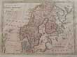
(Code No. 5132)
Bonne, M.
(Antique Map of Denmark, Norway, Sweden and Lapland.)
Le Nord de L'Europe, contenant le Danemark, la Norwege, la Suede et la Laponie; avec la Majeure Partie de la Russie Européenne".
Date. 1780.
: Paris, Bonne. Page size [11 x 16 1/2ins.] Original copper engraved Map of Northern Europe, Slight surface loss to bottom engraved margin. £50.00
|
Click on picture above to view more images
How to order |
|
(Code No. 5130)Bourgoanne, Chevalier De & M. Peyron.2 volumes.Travels in Spain: containing a new, accurate, and comprehensive view of the present state of that country ... To which are added copious extracts from the Essays on Spain of M. Peyron ... Translated from the FrenchDate. 1790.Dublin: P. Byrne; W. Jones. 8vo, [5 x 8ins.] Pp xiii, 386. 431, (x, index) + Folding map, very good. Original full calf gilt, surface leather loss & wear. Holding firm.
|
SOLD.
|
|
(Code No. 5065)Plan of the Works of the City of Messina, one of the strongest and most considerable Cities of Sicily, and a fine Sea Port.(Antique Map).Date. [c1745].England. Image size, [18 1/2 x 14ins]. Original copper engraved plate, Lacks 2 title letters and outer margins frayed, not affecting the engraved image. Taken from "Mr. Tindal's Continuation of Mr. Rapin's History of England"
|
SOLD.
|
|
(Code No. 5059)
BELL, James.
A System of Geography, Popular and Scientific; or, A Physical, Political, and Statistical Account of the World and its various Divisions.
Volume 2, Part 2.
Date. 1846.
London: A. Fullarton and Co. 8vo, [6 x 9ins.] Pp. xi, 323-667 + 2 Steel engraved prints of Babylon & Athens, creased and dust marked + 2 Folding maps, Sweden/Norway and Italy. Image sizes, (approx), 13 1/2 x 7 and 9 x 71/2ins. Original cloth gilt, faded. £35.00
|
Click on picture above to view more images
How to order |
|
(Code No. 5044)O'Meara, Barry E.Napoleon in Exile; or A Voice from St. Helena.2 Volumes.Date. 1822.London, W. Simpkin and R. Marshall. 8vo, [5 1/2 x 8 1/2ins.] , 4th edn. Pp. xxviii, 512, 542, slight foxing & one page damaged + 3 frontis portraits + one lithographic view plate. Original half calf marked with slight split to hinges. Holding firm. Napoleone di Buonaparte; (1769 -1821), was a military and political leader of France and Emperor of the French as Napoleon I, whose actions shaped European politics in the early 19th century. After his defeat at the Battle of Waterloo, Napoleon was imprisoned and then exiled to the island of Saint Helena in the Atlantic Ocean.
|
SOLD.
|
|
(Code No. 4977)[i.e. Joliffe,Thomas R.]Narrative of an Excursion from Corfu to Smyrna; comprising a progress through Albania and the north of Greece; with some account of Athens ... To which is annexed, a translation of the Erastæ of Plato. By the author of “Letters from Palestine”.Date. 1827.London : Black, Young & Young, 8vo, [5 1/2 x 8 1/2ins]. Pp xv. 271, one corner water staining throughout. Original half calf with raised spine bands and gilt -decorated panels, slight rubbing. Marbles boards, rubbed.
|
SOLD.
|
|
(Code No. 4949)
(Antique Map.)
A New and correct Map of the Russian Empire, as Comprehended in Europe and Asia from the best Authorities and Latest Improvements.
Date. [c.1780.]
London. Alex Hogg. Image size 7 1/2 x 11ins, (approx). Page size 15 X 9 1/2 ins, (approx). Copper engraved map with original outline hand-colour. Decorated border. Taken from Millar's Geography. £40.00
|
Click on picture above to view more images
How to order |
|
(Code No. 4940)
Ireland from the Best Authorities.
(Antique Map of Ireland.)
Date. [c.1800.]
London, Page size, [10 x 8 3/4ins.] Original copper engraved folding map. Taken from William Guthrie's Atlas "A New Geographical, Historical, and Commercial Grammar" £45.00
|
Click on picture above to view more images
How to order |
|
(Code No. 4938)
Holborn.
An Accurate Map of Italy.
Date. 1780.
London, Page size, [15 x 9 ins.] Original copper engraved print of Italy & Sicily, Corsica, Sardinia and the Adriatic coast, slight marks. £30.00
|
Click on picture above to view more images
How to order |
|
(Code No. 4896)
BELL, James.
A System of Geography, Popular and Scientific; or, A Physical, Political, and Statistical Account of the World and its various Divisions.
Date. 1846.
Volume 2, Part 1.
London: A Fullarton and Co. 8vo, [6 x 9ins.] Pp.320 + Steel engraved prints of "Liverpool from Seacombe" and "Rome from the Tiber" + 3 Folding maps of Denmark, Germany, (northern part) and Germany, (south part). (Image size 9 x 7 1/2ins), slight foxing Original cloth gilt. marked and faded spine. £40.00
|
Click on picture above to view more images
How to order |
|
(Code No. 4893)
Björkfeldt, Leonard (illustrator).
Album de Trollhätta. Collection des vues, les plus pittoresque et les plus remarquables de Trollhätta et de ses environs.
Date. 1847.
Gothenburg. D, F Bonnier. Oblong 4to [ 260 x 205 mm ]. 10 Engraved lithographs views of Trollhattan and environs, drawn by Leon Bjorkfeldt, engraved by E, Baerentzen, [ image size 190 x 140 mm ], ( French and Swedish text), slight foxing. Original boards gilt, rubbed and faded. Four of the beautiful lithograph views show the different canal lock systems and their workings with ships waiting to enter the locks. £110.00
|
Click on picture above to view more images
How to order |
|
(Code No. 4871)BRYCE, James.The Holy Roman Empire.Date. 1904.London, Macmillan, 8vo, [5 1/4 x 7 1/2ins.] Pp. lix, 571, very good. Including 3 folding coloured maps. Original full calf gilt with raised spine bands and gilt-decorated panels. Marbled edges. The Holy Roman Empire was a union of territories in Central Europe during the Middle Ages and the Early Modern period under a Holy Roman Emperor. The first emperor of the Holy Roman Empire was Otto I, crowned in 962. The last was Francis II, who abdicated and dissolved the Empire in 1806 during the Napoleonic Wars.
|
SOLD.
|
|
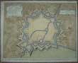
(Code No. 4728)
5 Large Geological Maps of Belgium.
Carte de la Belgique. E´chelle de 1:160,000.
Date. 1900-1915.
London] : [Geographical Section, General Staff]. Page sizes [28 x 35ins.] Folding to [7 x 9ins.] 5 Original printed coloured linen backed sectional geological maps, 6 sheets in 5, (as issued). Colour coded index to right side of map, very good condition. £100.00
|
Click on picture above to view more images
How to order |
|
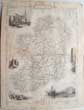
(Code No. 4676)
Levasseur, Victor .
(Antique County/Department maps of France.)
ATLAS NATIONAL ILLUSTRE DES 36 of 86 DEPARTEMENTS ET DES POSSESSIONS DE LA FRANCE.
Date. 1854.
Paris, A. Combette. Image size [16 1/4 x 11ins.] Page size 14 x 21ins. 37 of 86 Original steel engraved maps with original out line hand-colour, slight nicks to outer edges not affecting engraved areas. £220.00
Counties/Departments shown:- Ain, Aisne, Ardennes, Ariege, Aveyron, Cantal, Charente, Charente-Infer, Cher, Creuse, Eure, Finistere, Gard, Garonne, Herault, Ille-et-vilaine, Indre, Isere, Jura, Landes, Liore, Loire (Haute), Lozere, Marne(Haute), Meurthe, Meuse, Nievere, Puy-de-Dome, Sathhe, Somme, Vaucluse, Vienne, Vienne (Haute), Vosges, Yonne, very good condition. No Covers or Title.
|
Click on picture above to view more images
How to order |
|
(Code No. 4619)
WILD, Charles .
TWELVE ETCHED OUTLINES, Selected From The Architectural Sketches Made In Belgium, Germany, And France.
Date. 1833.
London. The Author. Folio, 10 1/2 x 14 1/2ins. Pp [2] 8 + 12 Etched plates on india paper, some marginal foxing. Original half calf, rubbed with some surface loss. £65.00
|
Click on picture above to view more images
How to order |
|
(Code No. 4609)
Davies, Christopher.
On Dutch Water-Ways. The Cruise of the SS Atlanta on the Rivers and Canals of Holland and the North of Belgium.
No Date, [c. 1890.]
London. Jarrold and Sons. 4to, 8 1/2 x 11ins. Pp vii 379 [1]. Photographic illustrations throughout. Original decorated cloth, Hinge cloth split and faded spine. Holding firm. £70.00
|
Click on picture above to view more images
How to order |
|
(Code No. 4575)Gibson. John.(Antique Miniature Map.)Spain & Portugal.Date. 1758-92. London. Image size 2 1/2 x 4ins. 8vo. Original copper engraved map, very good condition. Taken from "Atlas Minimus or A New set of Pocket Maps".
|
SOLD.
|
|
(Code No. 4532)
Society for the Diffusion of Useful Knowledge.
(Antique Maps.)
17 Maps of Europe.
Date. May, 1845.
London. S.D.U.K. Baldwin & Cradock, Page size 14 x 17ins. 17 Loose original steel engraved maps with outline hand colour of Germany parts 1, 2, 3. + Part 4 Germany & part 1of Austria on same map. + Austria, parts 2 and 3. + Poland + Russia, parts 1 to 9 + Europe. All very good condition. £85.00
|
Click on picture above to view more images
How to order |
|
(Code No. 4525)
Dielmann, Jakob Fürchtegott. (1809-1885).
13 Engraved aquatint views of Germany.
Date. [ca1840].
Frankfurt, Charles Jugel, Page size 7 x 5 1/2ins. Image size 4 x 2 3/4ins. 13 Loose engraved aquatint prints by Martens. Showing, 4 various views of Wiesbaden, 2 various views of Schwalbach, 4 various views of Ems, Adolphseck, Bieberich and Schlangenbad, some marginal foxing. £80.00
|
Click on picture above to view more images
How to order |
|
(Code No. 4444)
Anon.
5 Watercolour Sketches of Towns in Switzerland.
One image dated,1888.
Page sizes 5 1/2 x 8ins to 9 3/4 x 6 1/2ins. Image sizes 7 x 4ins to 5 1/2 x 8 3/4ins. 5 Original Watercolour sketckes of Swiss towns. Thun, Berne, Oberusel, slight foxing, and Vevey. On thick card. £170.00
|
Click on picture above to view more images
How to order |
|
(Code No. 4440)
BRADSHAW.
(Antique Town Plans of Europe.)
Plans of the most important Cities and Towns of Continental Europe,
Date. ca1870.
London. 12mo [ 120 x 150 mm ]. 28 of 29 FOLDING TOWN PLANS plans. Plan 28 [Vienna] missing. Approx Image sizes 190 x 140 mm to 660 x 460 mm. Plans include, Amsterdam,(2cm split to fold), Antwerp, Berlin, Brussels, Cologne, Constantinople,Dresden, Florence,Frankfort, Geneva,Genoa,Ghent, The Hague, Hamburge, Lyons, Marsailles, Mayence, Milan, Munich, Naples, Ostend, Palermo, Paris, Rome, Triest, Turin, Venice, Verona, very good condition. Printed covers, some wear. £110.00
|
Click on picture above to view more images
How to order |
|
(Code No. 4402)Anon.A New and Correct Map of Norway, Sweden and Denmark from the Latest Geographical Improvements.No Date. ca1782.Page size [15 x 9 1/2ins.] Original copper engraved map , very good condition.
|
SOLD.
|
|
(Code No. 4392)Four original pencil, pen and ink and watercolour drawings by an unknown Artist.Date. ca1850.Image size 7 x 5ins, (Approx) Showing:- Beautiful views of Montreux, Vevey and Lake of Geneva with the Alps and the Dent de Midi, viewed from the terrace of the Hotel Monet,very good condition. Mounted on card, foxing.
|
SOLD.
|
|
(Code No, 4385)Wordsworth, Christopher.Greece: Pictorial, Descriptive, and Historical.Date. 1839.London. William S. Orr. 8vo, [7 x 10ins.] Pp xxvii, 356, slight foxing + Engraved frontis + Vignette in title + 25 of 26 Steel engraved prints, (no plate cut out, publishing/binding error,) showing the scenery, architecture, etc of Greece, slight foxing + Many woodcutts illustrations. Original half calf, slight split to front hinge and rubbing.
|
SOLD.
|
|
(Code No. 4379)
(Antique Swiss Print)
Sentier Taille dans le Roc Vallee D'Oberhasli..(Canton de Berne).
(Path cuts in the Rock Valley D'Oberhasli.)
No Date. ca1850.
Image size 7 1/2 x 11 1/4ins. Page size 16 1/2 x 11 3/4ins. Original hand coloured lithographic print, heightened with gum arabic. Taken from the original painting by G. Neneuve. £50.00
|
Click on picture above to view more images
How to order |
|
(Code No. 4263)
Russell, John.
(Antique Map)
NETHERLANDS Drawn from the best Authorities.
Date. 1799.
London. Published as the Act directs by C. Dilly and others. Page size 22 x 17 ins. Image size 18 x 14 1/2 ins. Original hand-coloured copper engraved map by John Russell. From the Guthries's Geography, slight damage to bottom of blank margin. £40.00
|
Click to view more images
How to order |
|
(Code No. 4241)
Gambart Ernest, (1814-1902).
(2 Antique Prints of Switzerland.)
Mayence. (Switzerland).
No date,ca1850.
London. Page sizes [11 x 14 ins.] Image size [7 1/4 x 10 ins.] 2 Original hand-coloured lithographs, published by Ernest, Gambart with the "Gambart & Co" blind stamp in the left hand corner.
£70.00
He was a Belgian-born English art publisher and print dealer who dominated the London art world in the middle of the nineteenth century. He would become a model for how modern art business would be run. His main competitors were Agnew and Colnaghi.
|

Click to view more images
How to order |
|
(Code No. 4231)Schmid. F.( Antique Print of Switzerland.)A' Meyringen towards the Cascades of the Alpbach, Dorfbach and Mühlebach,Date, ca1830.Switzerland.Page size [15 1/2 x 10 1/2 ins]. Image size [9 1/2 x 6 1/2 ins ins.] Original hand-coloured aquatint print by R. Bodmer, nicks to blank margins well away from the engraved area.
|
SOLD
|
|
(Code No. 4213)
The Wedding Ceremony of Napoleon Bonaparte and Josephine, Empress of the French.
No Date. 19th century.
4to, [14 x 10 ins.] 2 Titles (French text), + 50 Loose engraved plates, (as issued), of the procession, wedding service and people involved, very good condition. Original plain covers.
They wed on March 9, 1796, just prior to his taking command of the army in Italy. The couple was crowned Emperor and Empress in 1804, and lived peacefully for two years. £80.00
|
Click to view more images
How to order |
|
(Code No. 4176)
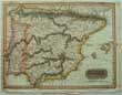
Keere, Van Den.
(Antique map of Spain).
HISPANIA.
Date, (1646).1666.
London. Roger Rea. Image size [5 x 3 1/2 ins.] Original hand coloured map. From Speed's Prospect of the Most Famous Parts of the World. £80.00
|
Click to view more images
How to order |
|
(Code No. 4174)Ortelius, Abraham. [1527-98.](Antique Map of Spain.)HISPANIA.Date, ca1601.Image size [5 x 3 1/2 ins.] Original copper engraved map, marks to blank margins. Guaranteed to be over 400 years old.
|
SOLD
|
|
(Code No. 4173)Cluverius, [Cluver], Phillip.(Antique map of Spain & Portugal.)Hispaniae Veteris et Novae Descriptio.Date, ca1680.Image size [10 1/2 x 12 1/2 ins.] Original copper engraved map by Philllip Cluverius, mark to right blank margin and one worm hole. Taken from the "Introductiois in Universam Geographiam...."
|
SOLD.
|
|
(Code No. 4170)John Tallis.Island in the Atlantic.[Antique Map.]London. Ca 1850. Size Approx 360 x 270mm. Original steel engraved map with original outline hand colouring. Six vignette views which includes Teneriffe, Madeira,. Decorated border. Centre fold. The map shows 4 inset panel maps, Bermudas. Canary Isles. Azores. Madeira.
|
SOLD.
|
|
(Code No. 4159)
Anon.
A New and Accurate Map of the Seven United Provinces including the Dutch Netherlands, etc.
London. Date ca1800. Image size, 11 x 9 ins. Original copper engraved with outline hand colouring. Blank margins damaged well away from the engraved area. £45.00
|
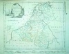
Click to view more images
How to order |
|
(Code No. 4160)Hall, s.Kingdom of the Netherlands.London. Longman... 1823. Image size 9 1/2 x 7 ins. Original copper engraved and drawn map by S, Hall. With original outline hand colouring.
|
SOLD.
|
|
(Code No. 4144)Kitchin. T.(Antique Map of Europe)
EUROPE Drawn from the latest and best Authorities.
London. J. Harrison. 1787. Original copper engraved map by G. Terry,Taken from Millar's New Complete & Universal System of Geography.
|
SOLD
|
|
(Code No. 4125)
Various Charts of Islands &c. in the Atlantic and Pacific Oceans.
London. Alex Hogg. ca1780. Image size 7 1/2 x 12ins, (approx). Page size 15 X 9 1/2 ins, (approx). Copper engraved map of Various Charts of the Islands &c. in the Atlantic and Pacific Oceans. Showing:- The Charts of the Northern Archipelago, discovered by the Russians in the seas of Kamtschatka & Anadir, Azores Isles, Cape Verd Isles, Canary Isles and Madera Isles. Decorated border. Taken from Millar's Geography. Three pages of text describing Cape Verd Isles,. £90.00
|
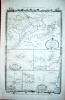
Click to view more images
How to order |
|
(Code No. 4038)
LEWALD, August. (1792-1871).
(Antique View Book of Switzerland).
Das malerische Schweizerland. 100 Ansichten mit einem Wort zur Charakteristik der Schweiz....
Carlsruhe, Karlsruhe, ca1840. Small 8vo, [110 x 140mm]. Pp 80 of 94 + 99 of 100 steel engraved plates of the most picturesque views of Switzerland, including two plates from another contemporary view book, slight foxing throughout. Original gilt decorated leather, hinges split with slight loss. Gilt top edge. £270.00
|

Click to view more images
How to order |
|
(Code No. 3981)Anon.
(Antique Map of Europe)EUROPE.
Date ca1830. Image size 11 1/2 x 8 1/2 ins. Original steel engraved map, splits to blank margin well away from the engraved area. 22 vignette views of European scenes surrounding the map, slight browning to top centre images.
|
SOLD
|
|
(Code No. 3979)Image size 10 1/4 x 8 ins. Page size 15 x 9 ins. Date, ca1782. Original copper engraved map with original outline hand colour.
|
SOLD
|
|
(Code No. 3963)London. Thomas Nelson & Sons. No date ca1900. 12mo, [4 1/2 x 6 1/2 ins.] Pp.480. illustrated throughout. Original blue cloth gilt, rubbed and faded.
|
SOLD
|
|
(Code No. 3936) Leipzig: Karl Baedeker, 12mo. Pp 578, 618, 424, 406, 512, 554, 491 & 58, 612. 1907 Faded spine & split to back hinge. Belgium and Holland 1891, Faded spine. Faded spine. Rhine 1911, Faded spine. slight split to top hinge. Tyrol and the Dolomites 1927, poor.
|
SOLD
|
|
(Code No. 3927)Antique Map of the West of Spain.Provincia Extremadura.ex originalibus D.T. Lopez curaverunt Homann Heredes.1791. Cum Gratia et Priv. S.C.M.' Date 1791.Size 17 1/2 x 18 1/2 ins. Original hand coloured copper engraved map by D.T. Lopez, of the west of Spain, 4 minute worm holes.
|
SOLD
|
|
(Code No. 3926)Russell, John.(Antique Map of ITALY).ITALY, Drawn from the best Authorities.London. Published as the Act directs by C.Dilly and others. 1799. Page size 22 x 17 ins. Image size 18 x 15 1/2 ins. Original copper engraved map by John Russell with original outline hand colour. From the Guthries's Geography, slight split to fold affecting blank margin.
|
SOLD.
|
|
(Code No. 3925)
Russell, John. (Antique Map of SWITZERLAND).
Switzerland Divided into its Cantons with their Allies and Subjects. Drawn from the best Authorities.
London. Published as the Act directs by C.Dilly and others. 1799. Page size 22 x 17 ins. Image size 18 x 15 1/2 ins. Original copper engraved map by John Russell with original outline hand colour. From the Guthries's Geography, slight damage to top blank margin. £60.00
|
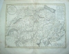
Click to view more images
How to order |
|
(Code No. 3831).London. 1765. Image size 8 x 9 ins. page size 8 1/2 x 9 3 /4 ins. Original copper engraved folding map, cropped to left border, slight split to fold.
|
SOLD
|
|
(Code No.3395)London & Edinburgh. A. Fullarton & Co. Size 12 1/2 x 18 1/2 inches. ca1860. Original steel engraved map with outline hand colour by A. Thom & A. Swanston. Showing two inset maps of the Islands of the Azores and Madeira. with vignette views of the people and natural history etc.
|
SOLD
|
|
(Code No. 3390)Ortelius, Abraham. 1527- 98. ( Antique Map of the Heel of Italian Boot.) ITALY. PUGLIA ."Apuliae quae olim Iapygia nova Corographia". Antwerp, ca1595. Map image size 311 x 217 mm. Copper engraved map with original hand colour after Jacobo Gastaldi's map of 1567. No text on the back of map. Taken from Abraham Ortelius’s atlas, "Theatrum Orbis Terrarum"
|
SOLD
|
|
(Code No. 3346)Conder. Thomas. (Antique Map). "EUROPE agreeable to the most approved Maps and Charts" London: A. Hogg. Image Size, approx 14 1/2 x 13 ins. Page Size 19 x 15 ins. 1782. Original folding copper engraved map with outline hand colouring, slight fold splits to blank margins, taken from Millar's Universal Geography. Decorative title cartouche. Graduated border. Compass Indicator, Scale, 200 miles to the Inch.
|
SOLD
|
| (Code No. 3350)Kitchin. Thomas. (Antique Map.): "A New & Correct Plan of HANOVER, a City in the Circle of Lower Saxony, and Capital of the King of Great Britain's German Dominions."London. A. Hogg. Image Size 111/2 x 8 ins. Page size 15 x 9 ins. ca1780. Original copper engraved Town Plan by J. Lodge. Showing fortifications, coat of arms, compass rose, houses and the garden designs and scale bar. Ornamental borders. |
SOLD
|
|
(Code no. 3012)Tallis, John:British Possessions in the Mediterranean. [Antique Map.]London. Ca 1850. Size Approx 360 x 275mm. Original steel engraved map with original outline hand colouring. 6 Hand coloured vignette views which includes Valetta, Gibraltar and Corfu. (Modern colouring.) Decorated border. Centre folding.
|
SOLD.
|
|
(Code No.3023)x 270mm. Original steel engraved town plan with original outline hand colouring.Five vignette views that includes The Royal Palace, Hotel de Ville. Decorated border. Centre fold, vg.
|
SOLD
|
|
(Code No.3024) London. Ca 1850. Size Approx 360 x 270mm. Original steel engraved map with original outline hand colouring. Seven vignette views that includes Cologne and Dresden. Decorated border. Centre fold, vg.
|
SOLD
|
|
(Code No.3029)Tallis, John. (Antique Map):Denmark.London. Ca 1850. Size Approx 360 x 275mm. Original steel engraved map with original outline hand colouring. 4 Vignette scenes that includes Copenhagen. Decorated border, vg. Centre fold.
|
SOLD.
|
| (Code No. 3030) London. Ca 1850. Size Approx 360 x 270mm. Original steel engraved map with original outline hand colouring. Four vignette views that includes Peths. Decorated border. Centre fold. |
SOLD
|
|
(Code No. 3307)
Playfair, James, Rev, 1738-1814. ( 3 Antique Maps.): Map of Russia in Asia with Adjacent Countries. Russia in Europe and Poland. London, Edinburgh. Vernon Hood, 1812. Page sizes 19 x 23 ins, approx. 3 Copper engraved maps, (slight foxing,) drawn and engraved by Dr Playfair and others. Taken from "A System of Geography" £77.00 |

Click to view more images
How to order
|
|
Return to top
|
|