SITE CONTENT
Antique Maps & Prints
Britain
Antique Maps - World
Antique Books
Cartographers
Early Prints
Other Stock
|
| Maps of South America |
Images |
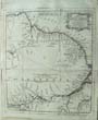
(Code No. 6816)
Tallis, John & John Rapkin.
(Antique Map).
Venezuela, New Granada, Equador, and the Guayanas.
Date. (c.1850).
London & New York, J.Tallis. Page size [14 x 10 1/2ins].Original steel engraved map with outline hand-colouring. Drawn and engraved by John Rapkin. Centre fold.
Showing: - 4 Vignette scenes of Paramaribo, Fall of Bagota, Chimborazo and a rural scene. very good condition........ £45.00 |
Click on picture above to view more images
How to order |
(Code No. 6762)
STEDMAN, J.G.; LIER, R.A.J. VAN (ed.)
Narrative of a Five Years Expedition Against the Revolted Negroes of Surinam, in Guiana on the Wild Coast of South America from the Years 1772 to 1777.
Date. 1972.
U.S.A. University of Massachusetts Press. 4to [8 1/4 x 11ins]. Pp. 480 + Illustrations throughout, very good condition. Original cloth gilt. No dust jacket.
Stedman left the Dutch Republic on 24 December 1772 after responding to a call for volunteers to serve in the West Indies. He was given the rank of Captain by way of a brevet, a temporary authorization for an officer to hold a higher rank. His corps comprised 800 volunteers to be sent to Surinam aboard the frigate Zeelust to assist local troops fighting against marauding bands of escaped slaves, known as Maroons, in the eastern region of the colony. The corps, which was trained for the battlefields of Europe, was unprepared for battle against the unfamiliar guerrilla tactics of its opponents.. Stedman vividly describes the landscapes of Surinam, paying great attention to detail. His observations of life in the colony encompass the different cultures that comprise the melting pot that developed there: Dutch, Scottish, native, African, Spanish, Portuguese, and French. Though the colony and the surrounding forests were filled with treachery and violence, in his Narrative Stedman takes time to describe the ordinary life and the happiness of certain situations in the colony....... £50.00 |
Click on picture above to view more images
How to order |
(Code No. 6761)
Thompson, Stanbury (Ed).
Journal of John Gabriel Stedman 1744-1797 Soldier and Author : Including an Authentic Account of His Expedition to Surinam in 1772.
Date. 1962.
London, Mitre Press, 8vo [6 x 9ins]. Pp. xxiv, 437 + Illustrations throughout. Original cloth gilt, very good. Owner's signature on past down. Dust jacket, nicks to edges with slight loss.
Stedman left the Dutch Republic on 24 December 1772 after responding to a call for volunteers to serve in the West Indies. He was given the rank of Captain by way of a brevet, a temporary authorization for an officer to hold a higher rank. His corps comprised 800 volunteers to be sent to Surinam aboard the frigate Zeelust to assist local troops fighting against marauding bands of escaped slaves, known as Maroons, in the eastern region of the colony. The corps, which was trained for the battlefields of Europe, was unprepared for battle against the unfamiliar guerrilla tactics of its opponents.. Stedman vividly describes the landscapes of Surinam, paying great attention to detail. His observations of life in the colony encompass the different cultures that comprise the melting pot that developed there: Dutch, Scottish, native, African, Spanish, Portuguese, and French. Though the colony and the surrounding forests were filled with treachery and violence, in his Narrative Stedman takes time to describe the ordinary life and the happiness of certain situations in the colony........ £30.00 |
Click on picture above to view more images
How to order |
(Code No. 6521)
Lubbock, Basil.
The Nitrate Clippers.
Date, 1932.
Glasgow; Brown, Son and Ferguson, Ltd. 4to, [8 x 10ins]. Owner's book plate on front past down. Pp. xii, 159 + Illustrations throughout includung one folding panorama of Iquique, South America, slight foxing. Original cloth gilt. Dust jacket with edge splits, no loss.......£30.00 |
Click on picture above to view more images
How to order |
(Code No. 5969)
Beebe, Mary. B and Charles. William.
Our Search for a Wilderness. An Account of Two Ornithological Expeditions to Venezuela and to British Guiana.
Date. 1910.
London. Constable & Co. 8vo, [6 x 9 ins]. University College, bookplate, (no stamps to text) Pp xix. 408. Illustrated throughout. Original decorated cloth, rubbed, slight marks. Library numbers to base of spine.
Mary Blair Beebe lived among indigenous peoples in Mexico, South America, and Southeast Asia. Charles William ("Will") Beebe was an American naturalist, explorer, and author. ...... . £80.00 |
Click on picture above to view more images
How to order |
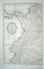
(Code No. 5556)
Kitchin, Thomas.
(Antique Map).
A Map of the Dutch Colonies of Surinam and Barbutius, and the French Colony of Cayenne; between the Orinoco and Amazon Rivers, in South America.
Date. [c.1760].
London, R. Baldwin. Map Size (approx), [8 1/2 x 7 1/2ins]. Original copper engraved folding map. Taken from "The London Magazine 1763".... £65.00 |
Click on picture above to view more images
How to order |
(Code No. 4882)
BELL, James.
A System of Geography, Popular and Scientific; or, A Physical, Political, and Statistical Account of the World and its various Divisions.
Date. 1838.
London: A Fullarton and Co. 8vo, [6 x 9ins.] Volume 6, Part 1. Ex library, no library stamps. Pp. 312 + Steel engraved print of Sydney, New South Wales + 3 Folding maps of Brazil, South America and Colombia, (Image size 9 x 7 1/2ins), slight foxing Original cloth gilt, faded. £35.00
|
Click on picture above to view more images
How to order |
| (Code No. 4411)
Bonne, Rigobert .1727-1794.
( 5 Maps of South American Countries, Brazil, Grenada, Guianas Peru and Chile.)
Carte de la partie Septentrionale du Bresil, Carte du Perou, Carte du nouv rem de Grenada de la noule Andalousie et de la Guyane, Carte du Chili, La Guyane Francoise avec Partie de la Guyane Hollandoise.....
Geneva. J.L. Pellet. Page sizes, [10 1/2 x 16ins.] ca1780. 5 Copper engraved maps. Engraved by Andre, slight marks and browning.The map of the Guiaanas shows the famous Devil’s Island and many Indian villages. Taken from "Atlas de Toutes les Parties Connues du Globe Terrestre" £80.00
|
Click on picture above to view more images
How to order |
| (Code No. 4256)
Kitchin. Thomas.
(Antique Map of South America).
Map of the Countries on the South Sea from Panama to Guayquil. For the Rev. D. Robertson's History of America.
London. W. Strahan & T. Cadell. Sept, 29th 1777. Image size 9 1/4 x 14 1/4 ins. Page size 10 1/2 x 16 1/2 ins. Original copper engraved folding map, slight splits to folds. £45.00
|
Click to view more images
How to order |
| (Code No. 4142)
DOWER, John.
Peru and Bolivia .
London. Henry Teesdale. 1831. Page size 18 x 14 ins. Original hand coloured copper engraved map, drawn and engraved by John Dower, slight split to centre fold. Taken from Teesdale's A New General Atlas of the World. £65.00
|

Click to view more images
How to order |
| (Code No. 4135)
Anon.
Map showing Jacob le Maire's voyage of 1615-1616.
No Date, ca1622.
Page size 14 1/4 x 6 ins. Original copper engraved folding map of South America, New Guinea and Tierra Del Fuego, creased.
Jacob Le Maire (ca1585 -1616) was a Dutch mariner, born in Antwerp, who circumnavigated the earth in 1615-16. He discovered the strait between Tierra del Fuego and Staten Island, Argentina; that strait is now named the Le Maire Strait in his honour.
He was the first person to round Cape Horn, proving that Tierra del Fuego was not a continent, by finding a new route to the Pacific and the Spice Islands. They followed the north coasts of New Ireland and New Guinea and visited adjacent islands. ....£120.00
|
Click on picture above to view more images
How to order
|
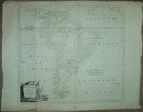
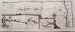
(Code No.3869)(Antique Map).MAP of the EUROPEAN SETTLEMENTS in SOUTH AMERICA and on the Western coast of AFRICA, 1784. Image size 17 3/4 x 12 1/2 ins. Page size 20 x 15 ins. Copper engraved folding map taken from Abbe Raynal's (1713-1796) "
A Philosophical and Political History of the Settlements and Trade of the Europeans in the East and West Indies" The map covers Chapapeck bay to Cape Horn and West Africa. The map has a garland style title cartouche, two scale lines, (1" to 320 miles) and graduated borders, very good condition.
|
SOLD
|
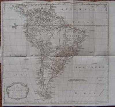
| (Code No. 3827).Kitchin. Thomas.(Antique Map of South America).
Map of South America. For the Rev. D. Robertson's History of America.
London. W. Strahan & T. Cadell. Sept, 29th 1777. Image size 12 3/4 x 17 1/4 ins. Page size 13 1/4 x 18 ins. Original copper engraved folding map, split to fold, repaired on back.
|
SOLD
|
| (Code No. 3804).
Macdonald. D.
(Antique map of South America.)
South America " New Sixpenny Maps, Embracing the Most Recent Discoveries"
Glasgow. D. Macdonald, 51 Argyll Street. ca1850. Page size 15 x 17 1/2 ins. Image size 14 1/2 x 13 ins. Original steel engraved hand coloured map. £75.00
|
Click to view more images
How to order |
| (Code No. 3399).
SWANSTON, G.H. & A. FULLARTON. (Antique Map)
West Coast of South America Including Chili & Part of Bolivia & Peru.
London & Edinburgh. A. Fullarton & Co. Size 12 1/2 x 18 1/2 inches. ca1860. Original steel engraved map with outline hand colour by A. Swanston, slight waterstaining to top right corner. Showing two inset maps of Peru & Bolivia and Chili with vignette views of the people, natural history etc. £75.00
|

Click to view more images
How to order
|
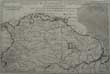
(Code No. 3396)
SWANSTON, G.H. & A. FULLARTON. (Antique Map)
"British Possessions on the North west Coast of South America".
London & Edinburgh. A. Fullarton & Co. Size 12 1/2 x 18 1/2 inches. ca1860. Original steel engraved map with outline hand colour by A. Swanston. Showing two inset maps of the Islands of Trinidad and British Guayana. with vignette views of the people, natural history and a sugar mill etc. £110.00
|
Click to view more images
How to order
|
(Code No. 3347)
Kitchin. Thomas, (Antique Map).
SOUTH AMERICA agreeable to the most approved Maps and Charts.
London: A. Hogg. Image Size, approx 14 1/2 x 13 ins. Page Size 19
x 15 ins. 1782. Original folding copper engraved map, from Millar's
Universal Geography. Decorative title cartouche Includes a native
American and animals etc. Graduated border. £90.00 |
Click to view more images
How to order |
(Code No. 3315)
Johnston, Keith and Adam and Charles, Black. (7 Antique Maps
of South America and West Indies):
"Brazil, Uruguay, Paraguay & Guayana" "Chili Argentine
& Bolivia", "Venezuela Colombia, Equador, Peru &
Bolivia", "Mexico", "South America (North and
South sheets)", "West Indies".
London.Edinburgh.
Blackwood and Son and A & C Black. ca1860-80,
approx size, 18 x 14 1/2 ins to 17 3/4 x 13 ins. . 3 Hand-coloured
in outline double page South American maps by K, Johnston and 4 colour
printed maps by A & C Black, (all loose, no text or covers).
Showing, South America (North and South sheets), nick to blank
margin and West Indies by Johnston and all the other maps are
by A & C
Black, vg. £55.00 |
Click to view more images
How to order |
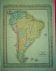
(Code No.2963)
Lodge, John. (Antique Map).
SOUTH AMERICA from the best authorities.,
London. 1781. Approx Size 35 x 41cms. Copper engraved map of
South America by John Lodge. Guaranteed to be over 200 years
old.
£88.00
|
Click to view more images
How to order |
(Code no.3017)London. nd Ca1850. Approx map size (
370 x 270 mm ). Original steel engraved map by J.Rapkin with original
outline hand colouring , vg. Seven vignette views, the Llamas and
Condors of Peru, descending the Cordilleras, Rio de Janeiro, a Brazilian
Bridge of Rope, and Gold Washing in Brazil. Decorated border, Nicks & dust marks to blank margins. Center fold.
|
SOLD
|
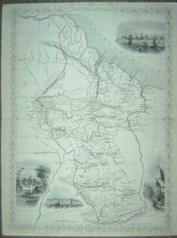
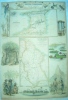
(Code No.3025)
Tallis, John. (Antique Map):
British Guayana.
London. Ca 1850. Size Approx 370 x 260mm. Original
steel engraved map with original outline hand colouring. 4 vignette
views, one view showing the town of Lima. Decorated border. Centre
fold, Very Good Condition £35.00 |
Click to view more images
How to order |
Return to top
|
|