SITE CONTENT
Antique Maps & Prints
Britain
Antique Maps - World
Antique Books
Cartographers
Early Prints
Other Stock
|
| Antique Prints,Maps and Books of Scotland |
Images |
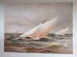
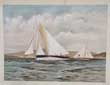
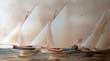
(Code No.6947).
SHIELDS, Henry & James. MEIKLE.
( Antique Print).
Famous Clyde Yachts 1880-87.
Plate 21.
Date. 1888, First and only Edition.
London: Oatts & Rungman. Large folio,(approx). [15 x 20ins]. Image size [8 x 11ins].. . Original chromolithographic print (coloured prints), taken from an original water colour by Henry Shields......£100.00 |
Click on picture above to view more images
How to order |
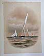
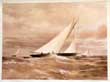
Code No.(6946)
SHIELDS, Henry & James. MEIKLE.
( Antique Print).
Famous Clyde Yachts 1880-87.
Plate 20.
Date. 1888, First and only Edition.
London: Oatts & Rungman. Large folio,(approx). [15 x 20ins]. Image size [8 x 11ins].. Original chromolithographic print (coloured prints), taken from an original water colour by Henry Shields... £100.00
|
Click on picture above to view more images
How to order |
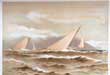
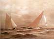
(Code No. 6945)
SHIELDS, Henry & James. MEIKLE.
( Antique Print).
Famous Clyde Yachts 1880-87.
Plate 22.
Date. 1888, First and only Edition.
London: Oatts & Rungman. Large folio,(approx). [15 x 20ins]. Image size [8 x 11ins].. Original chromolithographic print (coloured prints), taken from an original water colour by Henry Shields,...... £100.00 |
Click on picture above to view more images
How to order |
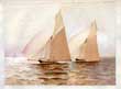
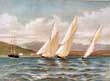
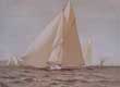
(Code No. 6918)
SHIELDS, Henry & James. MEIKLE.
Plate 24.
( Antique Print).
Date. 1888, First and only Edition.
Famous Clyde Yachts 1880-87. London: Oatts & Rungman. Large folio,(approx). [15 x 20ins]. Image size [8 x 11ins].. Original chromolithographic print (coloured print),taken from an original water colour by Henry Shields......£100.00 |
Click on picture above to view more images
How to order |
(Code No. 6916)
SHIELDS, Henry & James. MEIKLE.
( Antique Print).
Famous Clyde Yachts 1880-87.
Plate 27.
Date. 1888, First and only Edition.
London: Oatts & Rungman. Large folio,(approx). [15 x 20ins]. Image size [8 x 11ins].. Original chromolithographic print (coloured print) taken from an original water colour by Henry Shields,........ £100.00 |
Click on picture above to view more images
How to order |
(Code No. 6915)
SHIELDS, Henry & James. MEIKLE.
( Antique Print).
Famous Clyde Yachts 1880 -87
. Plate 25
Date. 1888, First and only Edition.
London: Oatts & Rungman. Large folio,(approx). [15 x 20ins]. Image size [8 x 11ins].. . Original chromolithographic print (coloured print) taken from an original water colour by Henry Shields.......£100.00 |
Click on picture above to view more images
How to order |
(Code No. 6879)
SHIELDS, Henry & James. MEIKLE.
( Antique Print).
Famous Clyde Yachts 1880-87.
Plate 28.
Date. 1888, First and only Edition.
London: Oatts & Rungman. Large folio,(approx). [15 x 20ins]. Image size [8 x 11ins].. . Original chromolithographic print (coloured print) taken from an original water colour by Henry Shields,,,,,,,, £100.00 |
Click on picture above to view more images
How to order |
(Code No. 6878)
SHIELDS, Henry & James. MEIKLE.
( Antique Print).
Famous Clyde Yachts 1880-87.
Plate 29.
Date. 1888, First and only Edition.
London: Oatts & Rungman. Large folio,(approx). [15 x 20ins]. Image size [8 x 11ins].. . Original chromolithographic print (coloured print) taken from an original water colour by Henry Shields,,,,,,,, £100.00 |
Click on picture above to view more images
How to order |
(Code No. 6876)
SHIELDS, Henry & James. MEIKLE.
( Antique Print).
Famous Clyde Yachts 1880-87.
Plate 30.
Date. 1888, First and only Edition.
London: Oatts & Rungman. Large folio,(approx). [15 x 20ins]. Image size [8 x 11ins].. . Original chromolithographic print (coloured print) taken from an original water colour by Henry Shields, slight foxing........ £100.00 |
Click on picture above to view more images
How to order |
(Code No. 6874)
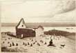
SHIELDS, Henry & James. MEIKLE.
( Antique Print). Famous Clyde Yachts 1880-87. Plate 31.
Date. 1888.
.. London: Oatts & Rungman. Large folio,(approx). [15 x 20ins]. Image size [8 x 11ins].. First and only Edition. Original chromolithographic print (coloured print) taken from an original water colour by Henry Shields, slight foxing to outer margins not affecting coloured image.
Showing; - Mosquito Class sailing boats........ £100.00 |

Click on picture above to view more images
How to order |
(Code No. 6833)
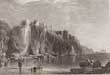
Wilson, Robert.
An Historical Account and Delineation of ABERDEEN ; Embellished with Beautiful Engravings of the Principal Bridges, Public Buildings, and Sacred Edifices in and about the City.
Date. 1822.
. Aberdeen, James Johnston.12mo, [4 1/2 x 7ins]. Pp. xii 226 (1) + 17 of 18 steel engraved plates. Lacks frontis. Half calf over marbled boards rubbed.............. £30.00 |
Click on picture above to view more images
How to order |
(Code No. 6459)
SHIELDS, Henry & James. MEIKLE.
Famous Clyde Yachts 1880-87.
Date. 1888, First and only Edition.
London: Oatts & Rungman. Large folio, [15 x 20ins]. 29 of 31 Mounted chromolithographic plates, slight foxing, Taken from the original watercolour drawings by Henry Shields (1859-1935). Each plate with a descriptive text. Gilt decorated cloth, slight marks..
Royal Clyde Yacht Club and the Northern Yacht Club can trace its roots back to 1824 when it began as a representation of Scottish and Irish fleets. A royal charter was granted in 1830 and it is believed the 'Northern' was the first yacht club to receive it. The two clubs dominated the Scottish yachting scene at that time. In 1886 the Royal Northern yacht Galatea challenged for the Americas Cup and the following year it was the turn of Thistle from the Royal Clyde.....£1500.00 |
Click on picture above to view more images
How to order |
(Code No. 6820)
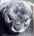
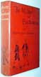
Maxwell, Gavin.
Ring of Bright Water.
Date. 1960 2nd imp.
London, Longmans. 8vo, [6 x 8 1/2ins].Pp.x 211 + Photographs & line drawings throughout..Original cloth gilt. Dust jacket slight rubbing to top edge.
Maxwell moved to Sandaig (which he called Camusfeàrna in his books), a small community opposite Eilean Iarmain on a remote part of the Scottish mainland. This is where his "otter books" are set. After Ring of Bright Water (1960), he wrote The Rocks Remain (1963), in which the otters Edal, Teko, Mossy and Monday show great differences in personality. The Rocks Remain is a sequel to Ring of Bright Water, and demonstrates the difficulty Maxwell was having, possibly as a result of his mental state......... £35.00 |
Click on picture above to view more images
How to order |
(Code. No. 6758)
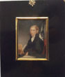
Anon.
Portrait miniature of James Mongomery.1771- 1854. (author).
Date. (c1809).
British. Wood frame with cast acorn hanger. Size [8 x 10ins], Image size [4 x 5 1/2ins].
Original hand-coloured portrait miniature (painter not known) of James Mongomery on cardboard, split to centre of image. Concave glass. Hand written in a contemporary hand,
Author and the book's title displayed with a full hand written title on back of image "James Montgomery Esq. author of the World before the Flood and West Indies etc"
James Montgomery was a Scottish-born poet, hymn writer and editor. He was concerned with humanitarian causes such as the abolition of slavery and of exploitation of child chimney sweeps. He wrote a poem addressing the French annexation of Switzerland and quickly went through two editions. When it was denounced the following year in the conservative Edinburgh Review as a poem that would be speedily forgotten, Lord Byron came to its defence in the satire English Bards and Scotch Reviewers.The poet's philanthropic enthusiasm and to his own touching associations with the West Indies. The four-part poem appeared in 1809 as "The West Indies". £180.00. |
Click on picture above to view more images
How to order |
(Code No. 6700)
BLACKWOOD'S EDINBURGH MAGAZINE 1872.
Dates. April, June, September, October, November, 1872.
In 5 parts.
Edinburgh, William Blackwood. 8vo, [6 x 9ins]. Pp. 5 parts (approx 130 pp per volume). Original decorated printed soft covers, chipping to top and bottom of spines.
Blackwood's Magazine was a British magazine and miscellany printed between 1817 and 1980. It was founded by the publisher William Blackwood and was originally called the Edinburgh Monthly Magazine. The first number appeared in April 1817 under the editorship of Thomas Pringle and James Cleghorn. The journal was unsuccessful and Blackwood fired Pringle and Cleghorn and relaunched the journal as Blackwood's Edinburgh Magazine under his own editorship. The journal eventually adopted the shorter name and from the relaunch often referred to itself as Maga. The title page bore the image of George Buchanan, a 16th-century Scottish historian. Important contributor includes ,Percy Bysshe Shelley....£30.00
|
Click on picture above to view more images
How to order |
(Code No. 6664)
Public Statutes. SCOTLAND.
Date. [c.1762].
London. Baskett. Folio, [9 x 13ins ].. Pp.112 including, (approx) 700 statutes.
Listing:- Scottish Law, Title deeds, Tenure, Schools, Parliament, Religion, Trade, Houses, Games. Customs, Alehouses, etc.No binding ......£50.00 |
Click on picture above to view more images
How to order |
(Code No. 6584)
Geddie, John & T. and R. Annan.
ILLUSTRATIONS OF THE SCENERY OF THE RIVER TAY: Reproduced in Photogravure by T. and R. Annan from Watercolour Drawings By Sir Wm. Fettes Douglas, R. B. Nisbet, Charles H. Mackie and James Paterson .
Date. 1891.
Edinburgh, Printed by T. and A. Constable for the Royal Association for the Promotion of the Fine Arts in Scotland, Folio, [14 x 10 1/2ins]. Pp. 30 + 13 Photogravure prints by T. and R. Annan. Original cloth gilt, faded.
James Annan subsequently joined his family's photographic business, T. & R. Annan and Sons of Glasgow, Hamilton and Edinburgh, and in 1883 went to Vienna to learn the process of photogravure. James Annan introduced the photogravure process into Britain, and T. & R. Annan, having acquired the British Patent holder rights, was to become the leading firm in Britain in gravure photographic printing...... £45.00 |
Click on picture above to view more images
How to order |
(Code No. 6522)
Clarke, J. Reverend.
The Wreck of the Orion: A Tribute of Gratitude.
Date. 1851.
London: Longman, Brown, Green.. 8vo. . Owner's book plate on front past down. Pp. viii, 87 + Map + 2 Lithographic views. Original cloth gilt, cloth hinge split. Holding firm.
The Orion was an iron paddle steamer built in Greenock in 1846. On 17th June 1850 she left Liverpool for Glasgow with 110 passengers on board. The next morning, navigating in a thick mist, she struck a submerged rock in the entrance to Portpatrick harbour. A huge hole was torn in the ship's watertight bulkheads and she sank within minutes. At least 60 passengers were drowned. Some were still asleep in their cabins and others were caught in the suction of the ship as she went down.....£100.00 |
Click on picture above to view more images
How to order |
(Code No. 6495)
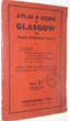
Atlas Guide to Glasgow for Empire Exhibition Visitors.
Date. [c.1938].
London, "Geographia" Ltd. 8vo, [5 x 7 1/4ins]. Pp. 30 including 8 Double page street plans + Plan of the Empire Exhibition, Bellahouston Park + 2 Folding maps of Glasgow and Scotland, very good condition. Original printed soft covers...
Empire Exhibition, Scotland 1938 (unofficially known as the British Empire Exhibition, Glasgow) was an international exposition held at Bellahouston Park in Glasgow, from May to December 1938.The Exhibition marked fifty years since Glasgow's first great exhibition, the International Exhibition (1888) held at Kelvingrove Park. It also offered a chance to boost the economy of Scotland, recovering from the depression of the 1930s....... £40.00 |
Click on picture above to view more images
How to order |
(Code No. 6356)THE TOPOGRAPHICAL, STATISTICAL, AND HISTORICAL GAZETTEER OF SCOTLAND.2 Volume bound up in 7 Divisions.Date. 1842.Glasgow. A. Fullarton. 4to [7 x 10 1/2 ins]. Pp. lxiv 814. 852. Unopened/unread. Large folding map of Scotland + 2 Town plans + 15 steel engraved view plates. Original trade cloth gilt , some marks and slight rubbing & chipping. Tight copies. Scottish Cities to the smallest Hamlet are described, their topography and chorography with some family histories, also interesting historical events are listed. Heavy Books......
|
SOLD.
|
(Code No. 6342)
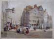
Leitch, William Leighton (British, (1804-1883).
EDINBURGH. Head of the West Row. (Lawnmarket).
(Antique Print).
Date. [c.1850].
London, Day & Son lithographers to the Queen. Page size [19 x 15 ins]. Image size [16 x 11ins]. . Original hand-coloured lithograph by T Picken, nicks and loss to outer margins. split into engraved area. (1/2inch). some foxing...
William Leighton Leitch was a Scottish landscape watercolour painter and illustrator. He was drawing master to Queen Victoria for 22 years and Vice President of the Royal Institute of Painters in Watercolours for twenty years...... £80.00 |
Click on picture above to view more images
How to order |
(Code No. 6329)Slezer, John.Facies Gwitatis Glascoae ab Austro - The Prospect of the Town of GLASGOW from ye South.Date. 1693 or a later edition?Scotland, John Jamieson. Page size, [ 19 x 12ins]. Image size [16 1/2 x 9 1/4 ins]. Original copper engraved hand-coloured print, nicks and loss to outer edges, not affecting coloured image.Taken from "Theatrum Scotiae" that contained engravings of Scottish cities by Slezer and text by Sir Robert Sibbald (1641-1722). Slezer was a Dutchman who moved to Scotland in 1669 and worked as an ordnance engineer before being appointed a captain of artillery by the Scottish Parliament......
|
SOLD.
|
(Code No. 6251)
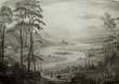
Hill, D. O.
(Antique Print).
Vale of Atholl. (Scotland).
Date. [c.1830].
Perth. Thos Hill, George Street. Page size [19 x 12ins]. Image size [14 x 10ins].Original lithographic print engraved by C. Hullmandel, creases to outer edges not affecting image...... £35.00 |
Click on picture above to view more images
How to order |
(Code No. 6249)
Rose, Thomas and others.
(Antique prints).
Scotland Illustrated.
Date. [c.1830].
Glasgow, Blackie & son. Various page sizes, (approx), [8 x 5ins]. Various image sizes, (approx), [4 x 6ins]. 26 Steel engraved view prints of Scotland, drawn by D. O Hill. Engraved by W. Forrest and others. Loose pages. No text or covers. Slight foxing mostly in the blank margins. ..... ......£35.00 |
Click on picture above to view more images
How to order |
(Code No. 6224)
The Scotsman, or Edinburgh Political and Literary Journal.
No.559.
Volume 9. Newspaper (1 issue).
Date. May 18, 1825.
Edinburgh: printed for the proprietor Charles Maclaren. Folio, [11 x 16ins]. 1825. Pp. 313 ot 320. No covers. Published every Wednesday and Saturday at £3 / 3s per Year or 16s per quarter.
The paper had a break-even circulation of 300 copies, but even those modest first steps attracted opprobrium. Taking The Scotsman, observed one Scottish peer, was to be an enemy of the government and copies were often smuggled to readers who dared not be seen buying it. The paper railed against the municipal Mafia of Edinburgh Town Council and supported parliamentary and municipal reform, as well as Catholic emancipation......... £30.00 |
Click on picture above to view more images
How to order |
(Code No. 6219)
Leighton, John.
(Print Salesman Specimen Copy. Part 1).
Select Views of the Lakes of Scotland.
Date. 1831.
... London, Moon, Boys & Graves. 4to, [9 x 11ins]. Pp. 14 + 3 Engraved views by Joseph Swan. Listing:- Loch Lomond, Ben Lomond, Loch Katrine.Original engraved soft covers, slight marks. Rare copy.....£45.00
|
Click on picture above to view more images
How to order |
(Code No. 6204)
Stevenson, Robert Louis.
The Master of Ballantrae; A Winter's Tale.
Date...July, 1889, 1st edn.
London, Cassell and Company. 8vo, Pp. 14 Line initial catalogue titles, viii, 332, [20 pp. Adverts, partially uncut]. The footnote on p. 41, lacks the L in "should". On page 90 the F in "from" is out of line. Original decorated red cloth gilt. Fine copy...... £120.00 |
Click on picture above to view more images
How to order |
(Code No. 6152)
Scott, Walter, Sir.
The lay of the last minstrel. A poem.
Date. 1809.
London, J. Sharpe, 8vo, Pp. 351, [16 adverts] + 6 Copper engraved plates by Richard Westall, foxing. Original full polished calf gilt. Raised spine bands with gilt decorated panels, slight surface loss & leather hinge splits. Holding firm.
Preface:- "The Poem, now offered to the Public, is intended to illustrate the customs and manners which anciently prevailed on the Borders of England and Scotland. The inhabitants living in a state partly pastoral and partly warlike, and combining habits of constant depredation with the influence of a rude spririt of chivalry"....... £40.00
|
Click on picture above to view more images
How to order |
(Code No. 6094)
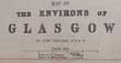
Weller, Edward.
(2 Antique maps).
Map of the Environs of GLASGOW & Map of the Environs of EDINBURGH.
Date. [c.1875].
London, George Philip and Son. Page sizes [20 x 13ins].Original engraved maps with hand-coloured, very good condition. Scale (approx), 1 inch to 2 miles. Showing railways and stations...... £35.00 |
Click on picture above to view more images
How to order |
(Code No. 6073)
Scott, Sir Walter.
5 Volumes, complete.
The Novels of Sir Walter Scott, Bart. With all his Introductions and Notes.
Date. 1843-47.
Edinburgh, Robert Cadell, 8vo. Pp. 817,794, 910, 839, [847 including glossary] + Engraved frontispieces & Fold-out facsimile of Scott's notes.
Listing:- Waverley, Guy Mannering, The Antiquary, Rob Roy, Old Mortality, Black Dwarf, Legend of Montrose, Heart of Mid-Lothian, Bride of Lammermoor, Ivanhoe, The Monastery, The Abbot, Kenilworth The Pirate The Fortunes of Nigel, Peveril of the Peak, Quentin Durward, St Ronan's well, Redgauntlet, Betrothed, Highland Widow, Talisman, Two Drovers, My Aunt Margaret's Mirror, Tapestried Chambers, The Death of Lairds Jock, Woodstock, Fair Maid of Perth, Anne of Grierstein, Count Robert of Paris, The Surgeon's Daughter and Castle Dangerous. Half morocco gilt with marbled edges. slight marks........ £100.00 |
Click on picture above to view more images
How to order |
(Code No. 5859)Kitchin, Thomas.A New Map of HADDINGTONSHIRE, (East Lothian Scotland), drawn from an actual Survey.Date. [c.1760].London, R. Baldwin. Map Size (approx), [8 x 6 1/2ins]. Original copper engraved folding map, marginal split to fold not affecting map image. Taken from "The London Magazine 1763".The Haddingtonshire constituency was created in 1708 and encompassed 3 towns (Haddington, Dunbar and North Berwick) which formed part of the separate constituency of Haddington Burghs. In 1918 it was amalgamated with neighbouring Berwickshire to form a new Berwick and Haddington constituency.......
|
SOLD.
|
(Code No. 5823)Robert Morden (c.1650-1703).(Antique Map).SCOTLAND.Date. 1695, 1st edn.London, Swale, Awnsham and Churchill. Page size [14 1/2 x 18ins]. In later editions Scotland is divided in two halves, north & south. Copper engraved County map of SCOTLAND by Robert Morden, damaged to bottom right corner.The map is based on John Speed's map. Scale, six English miles [ =1 1/2 in.]. Shell-type cartouche containing the title and Morden's name. The map has graduated borders. Taken from Camden's Britannia of 1695. was a British bookseller, publisher, and maker of maps and globes. He was among the first successful commercial map makers. Sold as a working copy only......
|
SOLD.
|
(Code No. 5787)BEATTIE, William.2 Volumes.Scotland Illustrated in a Series of Views taken Expressly for the Work by T. Allom & W. H. Bartlett.Date. 1838.London: Virtue & Co. 4to, [11 x 8 1/2ins]. Pp.viii, [2], 200, [ii], 164 + 2 Engraved vignette titles + Folding engraved map, slight split to fold + 118 Tissue guarded steel-engraved prints, very good condition. Original half morocco gilt, marble boards, raised spine bands gilt, elaborate gilt-decorated panels, slight rubbing. Gilt edges....
|
SOLD.
|
(Code No. 5765)
HAMILTON, Elizabeth.
The Cottagers of Glenburnie;
a Tale for the Farmer's Ingle-Nook.
Date. 1815, 6th edn.
Edinburgh, Manners and Miller, 12mo, pp. xii, 311, [1]. Original full calf gilt, rubbed with some spine leather loss.
Elizabeth Hamilton (1756-1816) was a British essayist, poet, satirist and novelist. Born in Belfast she lived most of her life in Scotland, moving there in 1762 to live with a Mrs Marshall, near Stirling and spending much of her later life in Edinburgh. She died in Harrogate, UK . Her first literary efforts were directed in supporting her brother Charles linguistic studies. After his death in 1792 she continued to publish historical, educationalist and theoretical works. She wrote The Cottagers of Glenburnie (1808), a tale that had an effect in the improvement of certain aspects of domestic life in Scotland..... £45.00 |
Click on picture above to view more images
How to order |
(Code No. 5740)WRIGHT, Thomas.The History of Scotland from The Earliest Period to the Present Time.Date. [c.1850].3 Volumes.London, John Tallis. 4to, Pp. viii, vi, 680. [II] vi, 672. [III] vi 638 + Map of Scotland by John Tallis + 42 Steel engraved prints, very good condition. Original half calf gilt. Raised spine bands gilt, slight marks......
|
SOLD.
|
(Code No. 5666)King, Jessie M.The Grey City of the North.Date. March, 1912.Edinburgh and London . T.N. Foulis, 8vo, [ 5 x 8 1/4ins.] 24 illustrations by Jessie King each with descriptive text, nick to outer margin of content page. Original decorated dust jacket, lacks 1inch of spine paper + some slight nicks to top and bottom edges. .....
|
SOLD.
|
(Code No. 5639)
Daniell, William 1769-1837.
(Antique Print.)
Remains of a Temple at Galston, Isle of Lewis.
Date. 1819.
London. Longman & Co. Image size 9 1/2 x 6 3/4. Page size 13 x 11ins. Original aquatint print drawn and engraved by William Daniell. Taken from "A Voyage round Great Britain".
William Daniell commenced a tour in a rowboat around Great Britain in the summers of the years 1813-16 starting and ending at Lands'-End in Cornwall. As he went he drew a series of 308 hand coloured sketches illustrating the character and prominent features of the coast. During the winter times he returned home to produce watercoloures and aquatints. A magnificient series of plates, almost all of equal quality . Valuable as a record and exquisite in its presentation. It is the most important plate book on British Topography..... £35.00 |
Click on picture above to view more images
How to order |
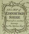
(Code No. 5543)
Kitchin, Thomas.
(Antique Map).
A New Map of Edinburgh Shire Drawn from a actual Survey.
Date. [c.1760].
London, R. Baldwin. Map Size (approx), [8 x 6 1/2ins]. Original copper engraved folding map. Taken from "The London Magazine 1763".... £65.00 |
Click on picture above to view more images
How to order |
(Code No. 5539)Budge, Donald.Jura, an island of Argyll: Its history, people and story.Date. 1960.Glasgow, John Smith. 8vo, [6 x 9ins]. Pp. xv, 206 + illustrated throughout, very good condition.Owner's name on front free end paper. Original cloth gilt. Dust jacket, poor. Rare copy......
|
SOLD.
|
(Code No. 5528)Kitchin, Thomas.A New Map of Linlithgowshire drawn from an actual Survey.Date. [c.1760].London, R. Baldwin. Map Size (approx), [8 x 6 1/2ins]. Original copper engraved folding map. Taken from "The London Magazine 1763"...
|
SOLD.
|
(Code No. 5513)Grant, James, 1822-1887.Cassell's Old and New Edinburgh: Its History, Its People, and Its Places. Illustrated by numerous engravings. .6 Divisions, (complete).Date. [c.1880].London, Cassell & Co. 8vo [8 x 10 1/2ins.] Pp. (approx), 180 per volume + 60 Woodcut & lithographic views and portraits, slight foxing + Many engraved text plates throughout. Original gilt-decorated cloth, slight marks and slight fading of the spines....
|
SOLD.
|
(Code No. 5486)
BAILLIE, Joanna, ( 1762 – 1851).
The Dramatic and Poetical Works of Joanna Baillie.
Date. 1853, 2nd edn.
London, Longman, Brown....4to, Pp. xxii, 847 + Frontis + Engraved title + Additional title. Original full calf gilt. Raised spine bands with gilt decorated panels, rubbing to the edges. Marbled edges and end papers.
Joanna Baillie was a Scottish poet and dramatist. Baillie was very well-known during her lifetime and, though a woman, intended her plays not for the closet but for the stage. Admired for her literary powers, she hosted a brilliant literary society in her cottage at Hampstead. Baillie died at the age of 88, her faculties remaining unimpaired to the last..... £50.00 |
Click on picture above to view more images
How to order |
(Code No. 5465)Ramsay, E. B.Reminiscences of Scottish Life and Character.Date. 1865, 12th edn.Edinburgh, Edmonston and Douglas. 12mo, [4 1/2 x 6 3/4ins]. Pp. ix, 272, very good. Listing:- Scottish humour, language, proverbs, stories, wit and domestic life, etc. Original half calf over marbled boards. Raised spine bands gilt, slight rubbing...
|
SOLD.
|
(Code No. 5439)
BURNS, Robert.
Poems by Robert Burns: with an Account of his Life, and Miscellaneous Remarks on his Writings. Containing also Many Poems and Letters, not printed in Doctor Currie's Edition.
2 Volumes.
Date. 1811.
Edinburgh, James Morison, John. Moir: 8vo, [ 215 x 140 mm ]. Pp. cxx 320, 357, [ 27 Glossary] + 2 Engraved frontis. Titles + 22 copper engraved plates slight offsetting and foxing . Modern leather spine with gilt decorated panels and black title labels retaining the original full calf boards, vg.... £115.00 |
Click on picture above to view more images
How to order |
(Code No. 5410)
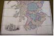
Stanford. Edward.
(2 Sectional Antique Maps).
A Map of SCOTLAND Divided into Counties Shewing the Principal Roads, Railways, Rivers, Canals, Lochs, Mountains, Islands etc.
Date. 1862.
London & Edinburgh, E. Stanford & Edmonston. Map size 75 x 52 ins in two parts, folding 5 1/2 x 10ins. Beautiful original hand coloured engraved map, mounted on linen, dissected into 72 sections. Fine calligraphic title. Beautiful large steel engraved vignette view of Melrose Abbey. Separate scale line, 1 inch to 5 statute miles. Elaborate star compass indicator. 12 line colour keys, "Explanation" churches, windmills, water mills, parks etc. Piano key graduated border with decorative corner devices. Folding into contemporary 4to morocco slipcase gilt, chipped and faded, (still firm). All housed in a contemporary leather book box, surface leather loss. Holding firm...
£550.00. |
Click on picture above to view more images
How to order |
(Code No. 5388)
TAYLOR, James.
A PICTORIAL HISTORY OF SCOTLAND from The Roman Invasion to the Close of the Jacobite Rebellion. A.D. 79 - 1746.
2 Volumes.
Date. [c.1850].
London, George Virtue, 4to, [7 1/2 x 10ins.] Pp. 808, [xciv geology], 1023, slight foxing + 2 Steel engraved titles + 78 Steel engraved plates, including 41 steel engraved plates of Scottish views, 21 steel engraved portraits plates, 12 steel engraved antiquity & geology plates, etc, and 4 maps. Original half calf gilt. Raised spine bands with gilt decorated panels, rubbed and scuffed... £130.00 |
Click on picture above to view more images
How to order |
(Code No. 5383)
Wright, Thomas, 1810-1877.
The History of Scotland; from the earliest period to the present time ... Illustrated with portraits, etc.
3 Volumes.
Date. [c.1855.]
London. London Printing & Publishing Co. 8vo, [10 1/2 x 8ins.]. Pp. v, iv 680. iv, 672. iv, 646 + Folding map + 31 Tinted lithograph and uncoloured steel engraved plates. Showing:- Views, portraits, etc. Modern half morocco gilt.
Thomas. Wright, antiquary, born near Ludlow, of Quaker parentage. His first work was a History of Essex (1831-36). In 1836 he went to London, and adopted literature as a profession, devoting himself especially to archaeology, history, and biography. He held office in various societies such as the "Camden," "Percy," and "Shakespeare," . In all he was the author of over 80 publications, of which some of the chief are The Celt, the Roman, and the Saxon , Biographia Britannica Literaria , Queen Elizabeth and her Times , and History of Domestic Manners and Sentiments in England during the Middle Ages . He was superintendent of the excavation of the Roman city at Wroxeter in 1859.....£70.00 |
Click on picture above to view more images
How to order |
(Code No. 5319).Daniell, William 1769-1837.(Antique Print.)Remains of a Temple at Galston, Isle of Lewis.Date. 1819.London. Longman & Co. Image size 9 1/2 x 6 3/4. Page size 13 x 11ins. Original aquatint print drawn and engraved by William Daniell.Taken from "A Voyage round Great Britain". William Daniell commenced a tour in a rowboat around Great Britain in the summers of the years 1813-16 starting and ending at Lands'-End in Cornwall. As he went he drew a series of 308 hand coloured sketches illustrating the character and prominent features of the coast. During the winter times he returned home to produce watercoloures and aquatints. A magnificient series of plates, almost all of equal quality . Valuable as a record and exquisite in its presentation. It is the most important plate book on British Topography.
|
SOLD.
|
(Code No. 5289).Edinburgh Trade Directory Edinburgh and Leith Post Office Directory.Date. 1946-47.1946-47. Edinburgh , Morrison and Gibb Ltd. 8vo, [6 x 9ins.] . Pp. xxii, 1588, [3] adverts, very good condition. Original cloth gilt, spine faded & slight split to top of spine cloth.Listing: - Streets and houses with their named occupants, Places of amusement, Trade directory, Professions, County directory, Telephone numbers and advertisers, etc.
|
SOLD.
|
(Code No. 5163)Fraser, Robert W.Illustrative Views in Tinted Lithography of Interesting and Romantic Parish Kirks and Manses in Scotland: With Preface and Introduction.Date. [c.1850].Edinburgh, A Fullarton & Co. 4to, [10 x 12ins.] Pp xiv + 25 Lithograph plates, very good condition. Original quarter morocco gilt over gilt decorated cloth boards, rubbed and faded. Gilt edges.
|
SOLD.
|
(Code No. 5155)Moll, Herman.(Antique map of Scotland.)Argyle, Lorn, Knapdale, and Cowal. All Parts of Argyle Shire.Date. 1745.London, Bowles and Bowles. Page size [11 1/2 x 9ins.] . Original copper engraved map of Argyleshire, rubbed with some surface loss.
|
SOLD.
|
(Code No. MG5184)THE SCOTTISH TOURIST and Itinerary; or, A Guide to the Scenery and Antiquities of Scotland and the Western Islands, with a description of the principal Steam-Boat Tours.Date. 1834, 5th edn.Edinburgh, Stirling, Kenney. 8vo, [4 1/2 x 7ins.]. Pp. xix, 455 + 7 Steel engraved maps + 12 Steel engraved plates, marginal foxing. No covers.
|
SOLD.
|
(Code No. 5155)Moll, Herman.(Antique map of Scotland.)Argyle, Lorn, Knapdale, and Cowal. All Parts of Argyle Shire.Date. 1745.London, Bowles and Bowles. Page size [11 1/2 x 9ins.] Original copper engraved map of Argyleshire, rubbed with some surface loss.
|
SOLD.
|
(Code No. 5032)Moncrieff, A R Hope.Bonnie Scotland.Date. 1905London, A & C Black. Pp. xi, 255 + 75 full-page colour illustrations by Sutton Palmer. Original decorated cloth gilt. Minor foxing on edges of some pages. Top edge gilt.
|
SOLD.
|
(Code No. 5030)Munro, Neil, 1864-1930.The Clyde River and Firth. Painted by Mary Y. and J. Young Hunter. Described by N. Munro.Date. 1907London, Adam & Charles Black: Pp. xi. 206, [6 adverts] + 67 colour plates and a folding map at the rear. Original gilt-decorated cloth, very good.
|
SOLD.
|
(Code No. 5026)
Speedy, Thomas.
Sport in the Highlands and Lowlands of Scotland with Rod and Gun.
Date. 1886.
Edinburgh, William Blackwood and Sons. 8vo, [6 1/2 x 9ins]. Pp. xx, 444, 4. + illustrations throughout. Original cloth gilt, slight hinge split. No dust jacket. £65.00 |
Click on picture above to view more images
How to order |
| (Code No. 5025)Mackenzie, W. C.The Book of the Lews. The Story of a Hebridean Isle.Date. 1919.Paisley , Alexander Gardner, 8vo, [6 x 9ins]. Pp. xv, [2], 276, [5 adverts] + illustrations throughout, very good. Original cloth gilt, very good. No dust jacket. The Hebrides comprise a widespread and diverse archipelago off the west coast of Scotland. There are two main groups: the Inner and Outer Hebrides. These islands have a long history of occupation dating back to the Mesolithic and the culture of the residents has been affected by the successive influences of Celtic, Norse and English speaking peoples, which is reflected in the names given to the islands.
|
SOLD.
|
| (Code No. 4979)Ecosse.(Antique Map of Scotland.)Date. 1860.Paris, Migeon ,11, Rue de Moulin Vert. Page size [15 x 19 1/2ins.] Original hand-coloured steel engraved map, slight crease. Taken from "Géographie Universelleis" .
|
SOLD.
|
| (Code No. 4801)SWARBRECK, Samuel (1830-1865).(Antique Print.)The Trongate, Glasgow with the Old Tower the only part now remaining of the Tolbooth celebrated in Rob Roy.Date. 1837.Size 12 x 18ins. Original lithographic engraved print, slight cropping to top edge and one edge nick. Taken from the "Sketches in Scotland by Samuel. Swarbreck, he was an important painter and lithographer of architectural and topographical views.
|
SOLD.
|
| (Code No. 4620)Ortelius. A.(Antique Map of Scotland.)Scotiae Tabula.Date. [c.1600].Antwerp. Plantin Press, Image size 19 1/2 x 13 1/2 inches. Page size 22 x 17 3/4 inches. Spanish text on reverse. Original copper engraved map, very good condition. Taken from the Theatrum Orbis Terrarum.Ortelius (Abraham Ortels) (April 2, 1527 - June 28, 1598) was a Belgian cartographer and geographer, generally recognised as the creator of the first modern atlas. On May 20, 1570, Gilles Coppens de Diest at Antwerp issued Ortelius' Theatrum Orbis Terrarum, the "first modern atlas" (of 53 maps). Three Latin editions of this (besides a Dutch, a French and a German edition) appeared before the end of 1572; twenty-five editions came out before Ortelius' death in 1598; and several others were published subsequently, for the atlas continued to be in demand until about 1612. From Wikipedia, the free encyclopaedia..
|
SOLD.
|
(Code No.4548)
MacIntosh, John.
Ayrshire Nights' Entertainments .....
Date. 1894.
Kilmarnock. Dunlop & Drennan. 8vo, 5 1/4 x 8ins. Pp. viii 400, (ix index.), slight marks. Original decorated cloth gilt, slight marks. £65.00
|
Click on picture above to view more images
How to order |
(Code No. 4437)Burns, Robert.Poems of Robert Burns with a Glossary.2 Volumes.Date. 1881.London. W. Kent & Co. 16mo, [3 x 4 1/2ins.] Pp 316,320, very good condition.All edges gilt. Original cloth, gilt, very good condition.
|
SOLD.
|
(Code No. 4367)William R. A. Daniell, [1769-1837].The Gair-Loch Ross-shire.( Scotland ).Date. 1816.London. Longman & Co. Image size 9 1/2 x 6 3/4. Original hand coloured aquatint, drawn and engraved by William Daniell, laid on to thick board.Taken from "A Voyage round Great Britain" No 125. Volume 4.William Daniell commenced a tour in a rowboat around Great Britain in the summers of the years 1813-16 starting and ending at Lands'-End in Cornwall. As he went he drew a series of 308 hand coloured sketches illustrating the character and prominent features of the coast. During the winter times he returned home to produce watercoloures and aquatints.
A magnificent series of plates, almost all of equal quality. Valuable as a record and exquisite in its presentation. It is the most important plate book on British Topography.
|
SOLD.
|
(Code No. 4293)Harrison. J(Antique Map of Scotland.)Map of Scotland from the Latest Discoveries.London. 23rd May 1787. Page size [16 1/2 x 17 1/2 ins.] Original copper engraved folding map with an inset map of the Orkney Isles, very good condition. Taken from the "Geographical Magazine". A rare map.
|
SOLD.
|
(Code No. 4205)Wood, John.Plan of Dumbarton from Actual Survey made by John Wood in 1818.Dumbarton & Edinburgh. 1818. Page size 21 x 29 ins. Image size 20 x 15 ins. Original engraved folding town plan, nicks to outer blank margins. Showing houses and land, with the named owner.
|
SOLD.
|
(Code No. 4012)Collie, James.The Royal Palace of Linlithgow, Illustrated.London: Edinburgh. J. Weale and others. Ca1850s Folio, [14.6 x 10.6 ins] Pp iv 32 marks and slight foxing. 8 Full - page lithograph plates on Indian paper with tissue guards and 8 text illustrations, watermarks and foxing in blank margins. Original Cloth gilt, marks and damage to spine. All edges gilt.
|
SOLD.
|
(Code No. 3946)George Philip & Son,Ordnance Survey Linen-Backed maps of Scotland.Philip & Son & London.Geographical Institute. No date.1905-10.17 Coloured linen-backed sectional strip maps, image on both sides on 9 leaves that includes index map (drawn by) John Bartholomew. The larger strip size 110 x 9 ins to smaller size 50 x 9 ins, folding to 4 x 9 ins. Scale 2 inches to 1 statute mile. Held in the original full morocco box with lock, (no key). Size 10 x 4 1/4 ins.
|
SOLD
|
(Code No. 3938)Baddeley M.J.B.(2 Scottish "Through Guides".) 2 Volumes. Scotland.Part 1. Edinburgh, Glasgow and the Highlands.Scotland Part 3 Lowlands.London, Dulau & Co & T. Nelson. 1889. 1908. 12mo. Pp 198, 48 adverts. 297, 76 adverts. Maps & Town plans throughout. Original cloth gilt, part 1, rubbed and top of spine chipped.
|
SOLD.
|
(Code No.3812).Macdonald. D.(Antique map of Scotland).Scotland. "New Sixpenny Maps, Embracing the Most Recent Discoveries"Glasgow. D. Macdonald, 51 Argyll Street. ca1850. Page size 15 x 17 1/2 ins. Image size 14 1/2 x 13 ins. Original steel engraved hand coloured map , Brown mark to right side of map's margin & image.
|
SOLD.
|
(Code No. 3723).Lydon, A.F.Scottish Loch Scenery.
London. John Walker. 1882. 4to [ 7 x 10 ins.] Pp 50. 21 of 25 tissue guarded chromolithographic, (printed colour) plates by S.B. Fawcett from drawings by A. F. Lydon, foxing to blank margins. Original gilt decorated cloth over bevelled boards, slight rubbing.
|
SOLD
|
| (Code No. 3348)London. T. Kitchin. Image size 11/4 x 81/2 ins. Page size 15 x 10
ins. ca1780. Original folding copper engraved map with outline hand
colouring, Decorative title cartouche includes a cow, fishing boat
and net etc. Graduated border. Compass Indicator and scale, 30 miles
to the Inch. |
SOLD
|
|
(Code No: 2647)Perrot, A. M. (Antique Map.)Edinburgh. Scotland.Paris. G.B. Depping. 1823. Map image size 70 x 105 mm. Copper
engraved map of Haddington, Edinburgh and Berwick. A tiny map
drawn as if on a pole screen with a large base title with an ornamental
background.
|
SOLD.
|
| (Code No. 2636.Collins. Greenville. Capt. (Antique
Sea Chart) " East Coast of Scotland with the Isles
of Orkney
and Shetland"London. 1693 or later edition. Image size
22.2 x 17.2 ins. Hand
coloured copper engraved map of East Coast of Scotland with the
Isles Orkney and Shetland. Compass rose with rhumb lines and sailing
ships, sounding, anchorages plus a coat of arms. Ornamental title
(Dedicated to Admiral George Rooke), and scale cartouche decorated
with cherubs etc. Graduated border. |
SOLD |
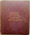
| (Code
No. 3195)
Bacon,
G. W.
Bacon's
New Survey Map of South Scotland. Dumbarton, Stirling, Clarksmannan,
Renfrew, Linlithgow, Edinburgh, Haddington, Berwick, Roxburgh, Selkirk,
Peebles, Lanark, Ayr, Bute, Wigtown, Kircudbright, Dumfries, Showing
Burghs, Parishes, Railways.
Manchester.
Deansgate. No Date, ca1880. Map size approx 47 x 38 ins folding
to 8 x 9 1/2 ins. Original full printed colour with out-line hand
coloured sectional linen backed map. (24 Sections), some linen sectional
hinges weak strengthened on back. Original cloth gilt, rubbing and
marks. £66.00
|
Click to view more images
How
to order
|
| (Code No.2639)Amsterdam,
1606. Image size 35.5 x 45.5cm Hand coloured copper engraved map
of North Scotland by Gerard Mercator. Superb ornate cartouche, watered-silk
rendering of the sea. Separate scale, (Scottish miles) |
SOLD |
Return to top
|
|