SITE CONTENT
Antique Maps & Prints
Britain
Antique Maps - World
Antique Books
Cartographers
Early Prints
Other Stock
|
| Maps, Prints & Books of Lancashire. |
Images |
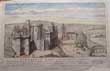
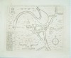
(Code No. 6847)
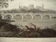
William R. A. Daniell, [1769-1837]
(Antique aquatint print).
View near lower Heysham, Lancashire.
Date. 4th March 1816.
London. Longman & Co. Image size [9 1/2 x 6 3/4]. Page size [14 3/4 x 10 3/4 ins].. Original aquatint, drawn and engraved by William Daniell. Taken from "A Voyage round Great Britain" No 41, Volume 2.
William Daniell commenced a tour in a rowboat around Great Britain in the summers of the years 1813-16 starting and ending at Land's-End in Cornwall. As he went he drew a series of 308 hand coloured sketches illustrating the character and prominent features of the coast. During the winter times he returned home to produce watercoloures and aquatints........£35.00 |
Click on picture above to view more images
How to order |
(Code No. 6840)
John Holt and Company of Liverpool and their African coast trade.
EBANI MONTHLY.
Volume 7. No.12.
Date. December 1931.
Liverpool. John & Co. 8vo [6 x 9ins] 1931. Pp. 301 - 324. Soft covers. Showing:- Promotions, left the company's service, leave of absence, etc. dance tunes for Christmas, department news, etc.......... £25.00 |
Click on picture above to view more images
How to order |
(Code No. 6832)Philips' New Map of Liverpool and its environs completed from actual surveys.Date. 1881.London, Liverpool. George Philip & Son. (approx) map size [60 x 43ins].Folding to [9 x 11ins]. Original folding linen backed coloured engraved section large scale map of Liverpool. slignt marks. Scale 6ins to 1 mile. Original cloth boards, hinges frayed.............
|
SOLD.
|
|
(Code No. 6715)
Brown, Richard. (Photographer)
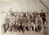
No 2 Special Service Department, Tank Corps, Seaforth. (Liverpool).
Date. August 1918.
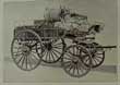
Liverpool, Richard Brown, Size [30 1/2 x 8ins]. Original panoramic photograph of the Tank corps just before they were disbanded, one crease not split....... £60.00.
|
Click on picture above to view more images
How to order
|
|
(Code No. 6662)
Clarke, H.
( Antique Ground Plan).
A Plan of the present Town of Manchester UK about the year 627.
Date. [c.1760].
Published by Manchester, N.H., J. B. Clarke.Page size [21 x 16 1/2ins]. Folding to (approx) [8 x 10ins].. Original copper engraved plan by T Taylor taken from an original drawing by H. Clark. Cropped when folded into the book....... £30.00
|
Click on picture above to view more images
How to order
|
|
(Code No. 6661)
Clarke, H.
( Antique Ground Plan).
A Ground Plot of the Town of Manchester,(UK) about the Year 800.
Date. [c.1760].
Published by Manchester, N.H., J. B. Clarke.Page size [21 x 16 1/2ins]. Folding to (approx) [8 x 10ins].. Original copper engraved plan by T Taylor taken from an original drawing by H. Clark. Cropped to left corner........ £30.00
|
Click on picture above to view more images
How to order
|
|
(Code No. 6658)
Baines, Thomas; Fairbairn, William.
Lancashire and Cheshire Past and Present.
A History and Description of the Palatine Counties of Lancaster and Chester. Forming the North-Western Division of England,,
Volumes 2 & 3 of 4 volumes.
Date. [c.1865].
London: William Mackenzie 4to, [10 x 12ins] Pp. 352 to 464. cclx. 352. Including the rise and progress of manufactures and commerce and civil and mechanical engineering in these districts by William Fairbairn + 13 Steel engraved plates, foxing, mostly marginal.. Original gilt decorated cloth. all edges gilt. Heavy books...... £55.00
|
Click on picture above to view more images
How to order
|
|
(Code No. 6569)
Twemlow, J. A. (Editor).
Liverpool Town Books - Proceedings of Assemblies, Common Councils, Portmoot, Courts, Etc, 1550-1862.
Volume 1, 1550-1571.
Date. 1918.
London, Constable & Co for the University of Liverpool....4to, [7 x 10ins].. Pp. ccxvi, 719 + 4 Folding facsimile documents. Original full cloth gilt, slight rubbing.
Listing:-Property rentals, Debts owing, Deeds, Sales, Lawsuits, Local history, etc........ £80.00
|
Click on picture above to view more images
How to order
|
|
(Code No. 6561)
Baines, Edward.
History of the County Palatine of Lancaster:
Volume 2 only.
Date. 1832.
London: Fisher, Son, & Jackson. 4to Pp 160, 2 + 36 Steel engraved plates on 32 leaves + 2 Folding Maps of Lancashire. Original quarter leather, surface loss to leather.
Edward Baines (1774–1848) was an English newspaper proprietor, politician, and author of historical and geographic works of reference. His political articles made him the organ of Liberal opinion in Leeds. Baines soon began to take a prominent part in politics; he was an ardent advocate of parliamentary reform, and it was mainly by his influence that Thomas Macaulay was returned for Leeds in 1832; and in 1834 he succeeded Macaulay as member. He was re-elected in 1835 and 1837, but resigned in 1841...... £65.00
|
Click on picture above to view more images
How to order
|
|
(Code No. 6545)THOMPSON, Isaac Cooke.British Association, Liverpool, 1896. Excursion Guide Book. Written by leaders of the excursions and others. Edited by Isaac C. Thompson ... With map, etc.Date. September 19th 1896 to October 1st 1896.Liverpool, Philip Son and Nephew. 12mo, [4 1/2 x 6 3/4ins].. Pp. vi, 96 + Folding Map. Excursion .Visiting Liverpool Overhead Railway, Speke Hall, Storeton Submarine Forest, Bidston Observatory, Chester, Railway Works at Horwich, Manchester Ship Canal, Weaver Navigation, Crewe Railway Works, Vyrnwy water works, English Lakes, etc. Original cloth gilt....
|
SOLD.
|
|
(Code No. 6534)
Williams, Gomer.
History of the Liverpool privateers and letters of marque with an account of the Liverpool slave trade.
Date. 1897.
London: Heinemann. 8vo, [6 x 9ins]. Pp. xv, 718 + 4 Folding facsimile prints. Owner's book plate on front past down. Original cloth covers, faded and shaken. Spine cloth poor. Holding firm..
Slavery in British colonies was finally abolished in 1833 and slave trading was made illegal in 1807 though some slavery apprenticeships ran until 1838. Many factors led to the demise of slavery including revolts, piracy, social unrest, and the repercussions of corruption such as slave insurance fraud, e.g. the Zong massacre case in 1783. It was Liverpool born politician William Roscoe who spearheaded the anti-Slavery movement in parliament at the time...... £80.00
|
Click on picture above to view more images
How to order
|
|
(Code No. 6529)
PILKINGTON, Lieut.-Colonel John.
The History of the Lancashire Family of Pilkington and its branches from 1066 to 1600.
Date. 1894. Signed presentation copy from the author to M. Clover.
Liverpool: Privately printed for the Author. 4to [7 x 10 3/4ins]. Pp.xv, 128, a few marginal notes + Illustrations, (as listed). Original gilt decorated cloth, faded..... £75.00
|
Click on picture above to view more images
How to order
|
|
(Code No. 6462)
BAINES, Thomas.
History of the Commerce and Town of LIVERPOOL, and of the rise of Manufacturing Industry in the adjoining Counties.
Date. 1852.
London, Longman....8vo, [7 x 9 1/2ins]. Pp. xvi, 844, 12, 13 + 3 Folding maps + Lithographic print of Liverpool. Original half calf gilt, rubbed & chipped.......£60.00
|

Click on picture above to view more images
How to order
|
|
(Code No. 6453)
Antique print.
Lancaster Castle in Lancashire. Built by Edward the third, and together with seven other castles taken from draughts now remaining among the Records of the Dutchy of Lancaster (by permission of the most Noble John Duke of Rutland.
Date. 1734.
UK, London. Society of Antiquities. Page size, (approx), [20 x 13ins]. 1734. Original copper engraved hand coloured large print, outer edges strenthened on the back not affecting image....
At the outbreak of the Civil War Lancaster was lightly garrisoned. A small Parliamentarian force captured the castle in February 1643, established a garrison and set about building earthworks around the approaches to the town. In response, the Royalists dispatched an army to retake Lancaster. The outer defences fell in March; a siege of the castle lasted just two days as Parliamentarian reinforcements were heading to Lancaster from Preston. The Royalists unsuccessfully tried to recapture Lancaster in April and again in June; the town and castle remained under Parliament's control until the end of the war..... £80.00
|
Click on picture above to view more images
How to order
|
|
(Code No. 6450)
Muir, Ramsay.
Bygone Liverpool.
Date. 1913.
Liverpool, Henry Young & Sons. 4to, [12 x 8 3/4ins]. . Pp. xlx, 97 + 97 plates from original drawings. Original cloth gilt, slight fading.
Ramsay Bryce Muir ( 1872 – 1941) was a British historian, Liberal Party politician and thinker who made a significant contribution to the development of liberal political philosophy in the 1920s and 1930s through his work on domestic industrial policy and his promotion of the international policy of interdependency........ £45.00
|
Click on picture above to view more images
How to order
|
|
(Code No. 6438)
Hope, E W.
City of Liverpool. Handbook compiled for the Congress of the Royal Institute of Public Health. 1903.
Date. 1903.
Liverpool. Lee & Nightingale. Folio, [ 9 1/2 x 11 1/2 ins.]. Pp xi, 330. Illustrated throughout, Original decorated cloth gilt,.faded spine.
In the early part of the 20th century, 16% of world tonnage of ships belonged to the port of Liverpool making it the 2nd city of the empire. This book deals with all aspects of the City of Liverpool, shipping, public buildings, public health, medical care, housing, transport, etc. ......£55.00
|
Click on picture above to view more images
How to order
|
|
(Code No. 6436)MOSS, William.The LIVERPOOL GUIDE Includng a Sketch of the Environs with a Map of the Town and Directions for Sea Bathing ...Date. 1799, 3rd edn.Liverpool, Printed By J M'Creery for W Jones, 8vo, [5 x 8ins]. . Pp. [2] + 168 + Folding copper engraved "Map of Liverpool", printer's ink marks. Marbled boards, crude modern spine tape. Holding firm.....
|
SOLD.
|
|
(Code No. 6432)
Gladstone, Robert:
Early Charters of the Knights Hospitallers relating to Much Woolton, Near Liverpool.
Date. 1903.
Liverpool: Thomas Brackell Ltd., 7 Folding plates. Pp 24 .[Reprinted from Transactions of the Historic Society of Lancashire & Cheshire ; Vol.liv. Author compliments on title page.
The Knights Hospitaller, also known as the Hospitallers, Order of Hospitallers, Knights of Saint John and Order of Saint John, were among the most famous of the Western Christian military orders during the Middle Ages. Full calf gilt, slight leather loss & marks...... £35.00
|

Click on picture above to view more images
How to order
|
|
(Code No. 6376)Box, Charles E.Liverpool Overhead Railway 1893-1956.Date. 1959.London, Railway World, 8vo, [6 x 9ins]. Pp. 189. Illustrated throughout. Original cloth. Dust jacket, slight chipping to spine.The work describes the building of the Overhead Railway, to its closing and demolition. Including historical illustrations. No effort has been spared to make this work as accurate as possible.......
|
SOLD.
|
|
(Code No. 6374)
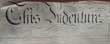
18 INDENTURES regarding the disposal of parcels of land for West Derby and Everton, Liverpool.
Dates. c.1840 - c.1875.
England, Liverpool. Sizes, (Approx), (27 x 21ins) folding to (9 1/2 x 8ins or less). 31 hand written leaves within 18 indentures, in a beautiful copper plate style on vellum parchments with elaborate initial lettering regarding the disposal of parcels of land + a few with hand-coloured ground plans.
Areas shown, (approx), 9 x West Derby, 6 x Everton, 2 x Edge Lane, etc + Royal stamps and signatories, etc....... £130.00.
|
Click on picture above to view more images
How to order
|
|
(Code No. 6355)Anderson, D.The Orrell Coalfield, Lancashire 1740-1850.Date. 1975.Buxton, Moorland Publishing Company. 8vo. [6 1/4 x 9ins]. Pp. 208 + illustrations throughout. Cloth gilt. Dust jacket, not price clipped.The coal measures of the Lancashire Coalfield were mined extensively at the Orrell Collieries between 1740 and 1850. A tramroad modelled on John Blenkinsop's railway at Middleton was built in 1812 from the pits to the Leeds and Liverpool Canal at Crooke. Robert Daglish was the engineer......
|
SOLD.
|
|
(Code No. 6241)Anon.LEVERPOOL, (Liverpool, UK).Date. (c.1740].London. Image size, [9 x 4 3/4ins]. Original hand-coloured copper engraved print, laid on to card with some surface loss.According to Harrison's 1898 study The Place Names of the Liverpool District; Or, The History and Meaning of the Local and River Names of South-west Lancashire and of Wirral, the earliest recording of the spelling was Leverpol in a deed of Richard I. Harrison notes that in King John's Charter (1207) the spelling is Liverpul while in a Charter of Henry III (1229) it is Litherpol. A variety of other spellings, including Lyverpol and Liverpull, may be found in other early official documents.......
|
SOLD.
|
|
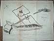
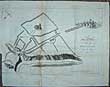
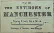
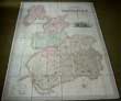
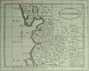
(Code No. 6225)
Map of the Environs of MANCHESTER &
Map of the Environs of LIVERPOOL.
(2 Antique Town Plans).
Date. [c.1875].
London, (George Philip and Son). Page sizes, (approx), [20 x 13ins]. 2 Original engraved Town Plans with hand-colour. Scale iinch to the Mile. ......£40.00
|
Click on picture above to view more images
How to order
|
|
(Code No. 6222)Lewis, K. P.35 Loose Photographs of Named Steam Shipping on The River Mersey between the 1920-1970s.Date. 1920-1970sLiverpool . 35 Photographs, description of the ships on back of photographs, signed by the photographer K. P Lewis, very good. Listing:- 26 Large photographs, approx, [10 1/2 x 8 ins]. 5 Medium, approx, [9 x 6ins]. 4 Small, Approx, [7 x 5ins].The Port of Liverpool served at one time more than 20,000 ships per year; Liverpool also became one of the United Kingdom's chief centres of shipbuilding activities, and provided the base for shipping giants such as the White Star Lines, who sailed the Titanic. .... .
|
SOLD.
|
|
(Code No. 6210)Croston, James.Historic sites of Lancashire and Cheshire.A wayfarer's notes in the Palatine counties, historical, legendary, genealogical, and descriptive.Date. 1883.London, Manchester, John Heywood. 8vo, Pp. xxvii, 499, a few corners water stained + Illustrations throughout. Original gilt decorated cloth, slight loss and marked.Of some of the families which have flourished or still flourish in these parts Mr. Croston gives us an account, illustrated and enlivened by many social and historical details. He is a genealogists which disapproves of the imaginary pedigrees to which some of the "Peerages' "give an undeserved authority. He requires proof before he credits his "county families" with a genuine antiquity......
|
SOLD.
|
|
(Code No. 6160)
HAND, Charles, R.
Olde Liverpoole and Its Charter.
Date. 1907.
Liverpool, Hand & Co. 8v, Pp. iv, 153, [2], 2 pages with slight nicks to outer edges. Including, (approx), 80 full page Liverpool adverts + A Liverpool history with illustrations. Original soft covers, slight chipping and darkened covers....... £35.00
|
Click on picture above to view more images
How to order
|
|
(Code No. 6034)Anon.Manchester and Liverpool Illustrated.Date. [c.1850].Britain. 4to [8 x 11ins]. Pp. 9 - 140 + 46 Steel & lithograph engraved view plates, image sizes, (approx), [8 1/2 x 6ins] to [6 x 4ins], some foxing.The work appears to be a composite of several Lancashire County Histories one being Austin's Lancashire illustrated or possibly a print seller's sample catalogue, some of the larger engravings are in a proof state giving no indication to which work it belongs. Original cloth gilt, slight rubbing.......
|
SOLD.
|
|
(Code No. 5996)Gore's Liverpool Directory, with Its Environs. 1821.Date. 1821.Liverpool, J. Gore....12mo, [4 1/4 x 7ins]. Pp. x, 328, [192....appendix]. Engraved vignette title with City of Liverpool armorial device. No map, not called for in listed of contents.Listing:- merchants, trades, principal inhabitants, officers of the customs and excise, stage and hackney coaches & carriers with their charges, etc..Original quarter morocco, chipped edges & rubbed. Holding firm.......
|
SOLD.
|
|
(Code No. 5995)Kelly's ... directory of Liverpool, 1962.including Bootle, Birkenhead, Wallasey and environs.Date. 1962.Kelly's Directory Ltd. 4to, 1962. Pp. 10 , xlix , [3], very good condition. Listing :- Streets, Private residents, Commercial and Trades, Alphabetical list of names, Advertisements, Institutions and Associations, Annals of Liverpool, etc. Original gilt decorated cloth, spine faded.
|
SOLD.
|
|
(Code No. 5958)
COOP, J. O. Rev.
The Story of the 55th (West Lancashire) Division.
Date. 1919.
Liverpool. Daily Post, 8vo. Pp 184, slight foxing. 10 coloured maps. 11 photographs some folding and 2 coloured plates of badges. Original printed boards,slightly marked. Cloth spine.......£60.00
|
Click on picture above to view more images
How to order
|
|
(Code No. 5942)Nock, O. S.The Lancashire & Yorkshire Railway.A concise history.Date. 1969.London, Ian Allen. 8vo, [6 1/4 x 9 1/4ins]. Pp. 159 + Illustrations throughout. Original cloth gilt. Dust Jacket, slight chipping & price clipped.This book shows how the development of engineering and commercial activities, and typified directors and staff alike. He shows how this great railway was developed and served by great men; so that the names of Armytage, Aspinall, Marriott, and Watson were almost synonymous with the initials L.Y. R........
|
SOLD.
|
|
(Code No. 5905)
Procter, Richard Wright, (1816-1881).
Memorials of Manchester Streets.
(Large-paper copy).
Date. 1874.
Manchester, T. Sutcliffe. 4to, Pp. xxii, 388 + 29 Engraved prints, (as listed). Original cloth gilt, part of lower spine cloth missing, (1/2in), & rubbing...... £60.00
|
Click on picture above to view more images
How to order
|
|
(Code No. 5904)
Barlow, Lieut and Captain Hawkins.
Liverpool (Bay).
Date. 1846-8. Revised 1850.
London, Ordnance Map Office. Image size, (approx), [74 x 55 1/2ins]. Hand-coloured engraved sectional map, laid on linen. Scale 6" to the statute mile. very good condition.
Areas shown:- Speke to Cunscough, Liverpool, Little Crosby, etc. . Listing:- Named farmes, houses, lanes, and Railways (London Northwestern Railway Edge Hill, Garston Branch, Liverpool Manchester and Lancashire and Yorkshire.) Original morocco slipcase, rubbed....... £350.00
|
Click on picture above to view more images
How to order
|
|
(Code No. 5902)Colby, Colenel.Ordnance Survey.Sheet Reference: LXXXIX S.W.......(Part of Lancashire. UK).Date. 1st August 1843.London, Ordnance Map Office. Image size, (approx), [13 x 14 1/4ins]. Hand-coloured engraved map, laid on linen. Scale 1" to the statute mile. very good condition.Showing:- Ormskirk, Knowsley, Adlington, Newton Makerfield, etc. . Listing:- Named farmes, houses, lanes, etc.......
|
SOLD.
|
|
(Code No. 5901)Colby, Colenel.Ordnance Survey.Sheet Reference: XC. S.E......(Lancashire UK).Date. 8th April 1842.London, Ordnance Map Office. Image size, (approx), [13 x 14 1/4ins]. Hand-coloured engraved map, laid on linen. Scale 1" to the statute mile. very good condition.Showing:- Maghull, Ince Blundell, Fornby, Bootle, Litherland, and Ainsdale areas. Listing:- Named farmes, houses, lanes, etc.......
|
SOLD.
|
|
(Code No. 5899)Philip, George & W. J. Cave.Philip's Trigonometrical Plan of the Town and Port of Liverpool,1858 revised 1875+ A Map of the Borough of Bootle cum Linacre.1869.Dates. 1875 & 1869.Liverpool, George Philip & Son, and W. J. Cave. Liverpool plan (in 2 halves north and south end), page size, [104 x 52ins] + Bootle plan, page size [35 1/2 x 42ins]. 3 Large lithographic hand-coloured sectional plans, laid on linen, very good condition. Original morocco slipcase, rubbed. .......
|
SOLD.
|
|
(Code No. 5884)
BENNISON, Jonathan.
(Antique Map).
A Map of the Town and Port of LIVERPOOL,
with their environs including Seacombe, Woodside, Birkenhead, Tranmere &c. From actual survey by Jonathan Bennison......
Date. 1835.
Liverpool, J. Bennison. Size, (approx), [1270 x 1768mm]. [71 x 51ins]. Large engraved map on a roller, laid on linen, nicks and frayed edges & lacking part of title. Scale 1: 8 100. Rare map.......£350.00
|
Click on picture above to view more images
How to order
|
|
(Code No. 5877)Cook. R J.(Antique Map).Township of Wavertree in the Parish of Childwall. County of Lancashire, (UK).Date. 31st December 1864.Liverpool, Page Size [52 x 25 ins]. Original hand drawn linen backed map, with pencil annotations, nicks to edges & taped repairs. "Traced at the Tithe Office from a second class tithe map 31st December 1864".Wavertree it is one of the oldest villages in the neighbourhood of Liverpool. There is evidence of a Pre-historic settlement in Victoria Park, with the burial urns that were excavated in the mid 1880's in North Drive being deposited at the Liverpool Museum........
|
SOLD.
|
|
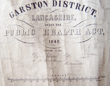
(Code No. 5872)
Gotto, Edward, (1822–1897).
(Antique Map).
Garston District "Public Health Act, 1848".
Surveyed, 1855.
Date. 1855.
London. Gotto, Edward. Page Size [40 x 73ins]. Image size [37 x 69 1/4ins]. Original lithographic linen backed town plan, dust stain & rubbing marks. Scale (approx), 200 feet to 1 inch.
Area shown, (approx), Aigburth Vale to Garston Salt Works. Garston is a district of Liverpool, Merseyside, England. Historically within Lancashire, it is bordered by Aigburth, Allerton and Speke. A small dock was first built at Garston in 1793 for Blackburne's Saltworks, which still stands today. Garston's growth accelerated rapidly in the 1840s, when in 1846, the area's first dock was constructed and opened, under the auspices of the St Helens and Runcorn Gap Railway Company. The "Old Dock" was followed twenty years later by a second, the "New Dock". In 1902, Garston was incorporated into the City of Liverpool.Speke boundary at Banks Rd near the old Match Works to Aigburth Vale, near Sefton Park and bounded by the old London & North Western Railway Line to Liverpool Lime Street, Allerton and Hunts Cross. Very rare...... £220.00
|
Click on picture above to view more images
How to order
|
|
(Code No. 5863)Bain. James. (ed.)The Authentic Map Directory of South Lancashire.Date. [c.1930] London. Geographia, Ltd. Folio, [ 10 x 14ins ].Pp. 208 + [92] Business Directory, Index to Streets & Railway stations including 192 FULL / DOUBLE PAGE COLOURED ORDNANCE SURVEY MAPS with named street plans, etc. 4" to the mile.Area bordering Wirral to Fulworth near Preston east to Nelson and Colne and south to Hazel Grove, Stockport. Showing tram, omnibus, railways and canal routes, farms, and schools, etc. All with distinctive colours. Original cloth gilt, very good.......
|
SOLD.
|
|
(Code No. 5698)Bowen, Emanuel.LANCASHIREDivided into its Hundreds containing the Burough & Market Towns, Rivers, Roads, Distances , etc.Date. 1761.London, W. Owen at Temple Bar. Image size [6 1/2 x 7ins] Page size [10 1/2 x 8ins]. Original copper engraved map of Lancashire. The title is in an ornamental cartouche with the “Explanation”. Left side a list of the hundreds with a circular compass indicator and scale. Engraved for the General Magazine of Arts & Sciences for W Owen & Temple Bar 1761......
|
SOLD
|
|
(Code No. 5667)
Hay, J. Hamilton.
LIVERPOOL / painted by J. Hamilton Hay ; described by Dixon Scott.
Date. 1907.
London : Black 8vo, [6 x 8ins]. Pp.xii, 169, slight foxing spots throughout + 25 Full-page illustrations in colour. Owner's signature on front free end paper. Original gilt decorated cloth, slight fading to spine...... £35.00
|
Click on picture above to view more images
How to order
|
|
(Code No. 5640)
HENNET, G & TEESDALE, Henry.
A Map of the County Palatine of Lancaster.
Divided into Hundreds and Parishes from an accurate Survey made in the Years 1828 and 1829.
Date. 1st May, 1830.
London. Henry Teesdale.4to, Original hand coloured, mounted on linen, engraved map, foxing spots, dissected into 48 sections. Map size 1,600 x 1,115 mm or 46 x 64 ins, folding into contemporary 4to tree calf slip-case gilt, rubbed and chipped. Fine large steel engraved vignette view of "The New Customs House, Liverpool" after a drawing by R. Barrow below fine calligraphic title. Separate scale line. 3/4 ins to 1 statute mile. Star compass indicator. 20 line with colour keys, "Explanation" churches, windmills, water mills, turnpike roads, houses and railways etc. ....£350.00
|
Click on picture above to view more images
How to order
|
|
(Code No. 5633)COLLINS, H G.(Antique Map).The British Gazetteer. Lancashire.Date. [c.1850].London, H. G. Collins. Page size [17 1/4 x 15 ins]. Original hand-coloured lithographic folding map. Listing:- Railways, Mail coach roads, Turnpike roads, Pollling places, Boroughs returning MPs, etc, very good condition.......
|
SOLD.
|
|
(Code No. 5614)COOP, J. Wallace.Bulls and Bears.Cartoons of members and ring traders of Liverpool Cotton Exchange. Cartoons by J. W. Coop. Biographies by Seymour Taylor. Reprinted from “The Liverpool Courier.”Date. 1908.. Liverpool, C. Tinling & Co. Folio, [10 x 15ins]. Pp. Title, [32], marginal foxing + 89 Engraved cartoons by W. J. Coop each with descriptive text, showing members and ring traders of Liverpool Cotton Exchange. Original cloth gilt, some marks.....
|
SOLD.
|
|
(Code No. 5413)Eyes, John.(Antique Print).The West Prospect of the Town of LIVERPOOL, as it appeared about the Year 1660.Date. Dec,1813Gentleman's Magazine. Page size 8 1/2 x 4 3/4ins. Image size 6 1/4 x 4ins.. Original copper engraved plate by B, Howlett, slight browing to top margin....
|
SOLD.
|
|
(Code No. 5411)HENNET, G.A Map of the County Palatine of Lancaster, Divided into Hundreds and Parishes from an accurate Survey made in the Years 1828 and 1829.Date. 1st May, 1830.London. Henry Teesdale.4to, Original hand coloured, mounted on linen, engraved map, dissected into 48 sections. Map size 1,600 x 1,115 mm or 46 x 64 ins, folding into contemporary 4to tree calf slip-case gilt, slight rubbing and chipping.Fine large steel engraved vignette view of "The New Customs House, Liverpool" after a drawing by R. Barrow below fine calligraphic title. Separate scale line. 3/4 ins to 1 statute mile. Star compass indicator. 20 line with colour keys, "Explanation" churches, windmills, water mills, turnpike roads, houses and railways etc.
|
SOLD.
|
|
(Code No. 5407)Leigh, Charles.The Natural History of Lancashire, Cheshire, and the Peak, in Derbyshire.Published for the Author.Date. 1700.Oxford. Folio, [9 x 14ins]. Pp. Lacks 1-4. pp. 5-192, pp. 1- 97, pp. 1-112, [30], lacks pp. 31-35 index.] + 23 Copper full page plates, some marginal damage, no loss. Lacks map of Lancashire. Modern cloth gilt....
|
SOLD.
|
|
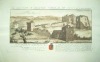
(Code No. 5223)
Farington, J. (1747 – 1821).
(Antique Print.)
North East View of Lancaster. (UK).
Date. Nov 1791.
London, W. Byrne. Page size 19 1/2 x 14ins. Image Size 12 x 18ins. Original copper engraved print by J. Landseer, repaired split to top right corner.
Farington's real forte lay in the careful, accurate topographical drawings which he prepared for the folios of engravings of British views which found a ready market among tourists confined to Britain by unrest abroad. In 1794 he published a two-volume History of the River Thames with 76 aquatints. £80.00
|
Click on picture above to view more images
How to order
|
|
(Code No. 5075)Barrow, R & Bartlett, W.H.(4 Antique Prints of Lancashire.)The Mersey at Liverpool, Canning Dock and Custom House Liverpool, Scene at Fleetwood on Wyre and South view of Saint Jame's Cemetery Liverpool.Date. [c.1840].London. T. Kaye & G. Virtue. Page sizes 10 1/2 x 8 1/4ins & 14 x 10ins. . 4 Original steel and lithograph engraved plates, very good, (2 hand-coloured)
|
SOLD.
|
|
(Code No. 5060)BAINES, Edward, M.P. for Leeds.(Trade Directory)History, Directory, and Gazetteer, of the County Palatine of Lancaster; with a variety of commercial & statistical information.2 Volumes.Dates. 1824, 1825.Liverpool : W. Wales & Co. 8vo, [5 x 8ins]. Pp. viii, 660.xii, 744, slight foxing. The title pages refer to Maps and Plans, they were issued separately. An early directory on Lancashire, a most comprehensive description of the principle towns and villages, their history including the names, trades and addresses of the inhabitants, from the Accountants to the Woollen drapers. Original full calf gilt, slight marks and slight split to hinge leather. holding firm. Marbled edges. Edward Baines (1774 – 1848), English newspaper-proprietor and politician, was born in 1774 at Walton-le-Dale, near Preston, Lancashire. In parliament he supported the Liberal party, but with independent views. Like his son Edward after him, he strongly advocated the separation of church and state, and opposed government interference in national education.
|
SOLD.
|
|
(Code No. 4941)
Davidson, A S.
Marine Art & Liverpool - painters, places & flag codes 1760-1960.
Date. 1986.
Wolverhampton, Waine Research Publications. 4to, [9 x 113/4ins.] Pp. 172. Black & white and coloured illustrations throughout. Including 100s of Ship's names, 1827, 1832 and 1836 editions. Leading Liverpool artists, with examples of their work and history, Merchant Ship flag codes, etc. Original morocco style cloth with price clipped dust jacket. £45.00
|
Click on picture above to view more images
How to order
|
|
(Code No. 4910)
Hyde, F. E, E. Midwinter and G. Chandler.
Liverpool and the North West, Old Liverpool, and Liverpool and the Mersey.
(3 Volumes on the City of Liverpool.)
Newton Abbot, David and Charles, Batsford. 8vo & 4to. 1971-72. Pp xvi, 269. 200. 149 photographs + Illustrations throughout. Original cloth gilt all with dust jackets. £35.00
|
Click on picture above to view more images
How to order
|
|
(Code No. 4902)Rees, John. S.History of the Liverpool Pilotage Service Mentioning the Local Lighthouses and Lightships.Date. 1949.Southport, Southport Guardian Ltd. 8vo, 6 x 8 1/2ins. Pp. 219 + Illustrations throughout, very good condition. Original cloth gilt, slight fading. No dust jacket. This work is the interesting story of the progress of Liverpool and the development of Liverpool's maritime activities. The greatest tribute that can be paid to the Liverpool pilotage is that other pilotage services used Liverpool as the model.
|
SOLD.
|
|
(Code No. 4800)
Lewis. Keith P, Carter J. M, & Palmer. William.T.
The River Mersey, Ships of the Mersey & Mersey Ferry Tale.
3 Volumes.
Date. 1943-44 &1966.
Liverpool, London. Hale, Record Books & Daily Post. 8vo, The River Mersey, pp 250, illustrated throughout, original cloth, no dust jacket. Ships of the Mersey pp 79 + two 7-inch LP records, illustrated throughout, 0riginal pictorial boards, slight rubbing. Mersey Ferry Tale. pp.35. original pictorial wraps, illustrated throughout, chipping to spine. £35.00.
|
Click on picture above to view more images
How to order.
|
|
(Code No. 4752)Moule, Thomas.LANCASHIRE.(Antique Map.)London. Virtue. Date 1836 -52. Approx size 270 x 215 mm. Taken from Barclay's Dictionary. Steel engraved county map of LANCASHIRE. decorated vignette Nelson's Monument Ornamental border with symbolic figures woven into the design, heraldic coat of arms. Moule's county maps are the last series of decorative maps to be published. Very slight cropping to right decorated border.
|
SOLD.
|
|
(Code No. 4751)Moule, Thomas.LANCASHIRE.(Antique Map).London. Virtue. Date 1836 -52. Approx size 270 x 215 mm. Taken from Barclay's Dictionary. Steel engraved county map of LANCASHIRE. decorated vignette Nelson's Monument Ornamental border with symbolic figures woven into the design, heraldic coat of arms. Moule's county maps are the last series of decorative maps to be published. Slight foxing.
|
SOLD.
|
|
(Code No. 4750)
Smith. William & John Speed.
(Antique Town Plan.)
Plan of Lancaster taken by Speed in the Reign of Elisabeth .
Date. Paper watermarked 1806.
London. Page size [8 x 7ins.] Copper engraved reprint of John Speed's Town Plan of Lancaster. £45.00
John Speed's collection of town plans are the first known plans of many towns. They include preference for ground plan over the perspective or bird's eye view. All plans have a list of streets, churches and other features keyed to the plan.
|
Click on picture above to view more images
How to order.
|
|
(Code No. 4749)Clark. Christopher.(Antique Town Plan.)A Plan of the Town of Lancaster. 1807.Lancaster & London. C. Clarke. Page size [12 x 8ins.] 1807. Original copper engraved folding Town Plan of Lancaster in the County of Lancashire, engraved by Neele.
|
SOLD,
|
|
(Code No. 4736)Classified Telephone Directory Business and Professional.Liverpool & South West Lancashire.Date. December 1939.London. J. Weiner Ltd & Her Majesty's Stationary Office. Folio, [8 1/2 x 11ins.] Pp 188 + Adverts throughout, some outer edges frayed. Original printed covers, frayed with some loss.
|
SOLD.
|
|
(Code No. 4710)William R. A. Daniell, [1769-1837].Liverpool taken from the opposite side of the River.Date. 1816.London. Longman & Co. Image size 9 1/2 x 6 3/4. Original hand coloured aquatint, drawn and engraved by William Daniell, slight foxing spots.Taken from "A Voyage round Great Britain" No 39. Volume 2. William Daniell commenced a tour in a rowboat around Great Britain in the summers of the years 1813-16 starting and ending at Land's-End in Cornwall. As he went he drew a series of 308 hand coloured sketches illustrating the character and prominent features of the coast. During the winter times he returned home to produce watercoloures and aquatints.
|
SOLD
|
|
(Code No. 4697)H. Austen.(Antique Map of Liverpool.)Liverpool, with its Parliamentary & Municipal Boundaries, with part of the River Mersey & Cheshire coast. Date. 1857.Liverpool. W. Townshend & T. Kaye. Page size 21 1/2 x 15 1/4ins folding to 3 x4 3/4ins. Dissected, linen backed map of Liverpool, Showing Parliamentary and Municipal Boundaries, together with part of the River Mersey and Cheshire Coast. Scale 1: 15 000 and 1: 18 500. (approx). Original cloth with paper title label, slight marks.
|
SOLD.
|
|
(Code No. 4627)Baines. Edward, (Edited By John Harland.)The History of the County Palatine and Duchy of Lancaster.2 Volumes.Date. 1868-70. London. George Routledge and Sons. 4to, [9 x 12ins]. Pp xxi, 690, [1]. xii, 729, part unopened + Large folding coloured map of Lancashire, some foxing + text illustrations throughout, very good condition. Original cloth gilt, hinge cloth split to volume 1.
|
SOLD.
|
|
(Code No. 4511)Tallis, John.[Antique Town Plan.]Town Plan of Preston.Date. Ca1850.London. London Printing and Publishing Company. Size Approx 14 1/4 x 10 3/4ins. Original steel engraved town plan with outline hand colouring. Seven vignette views, Preston and Wyre Viaduct and Grammar School, etc. Decorated coloured border. Centre fold, nicks to blank margins not affecting the engraved area.
|
SOLD.
|
|
(Code No. 4504) [By J. Corry?] [Engravings by T. Troughton].The History of Liverpool from the earliest authenticated period down to the present time. [By J. Corry?] Illustrated with views of the principal buildings in the town and its vicinity [by T.Troughton].Date. [1810.] Paper watermarked 1806.Liverpool. Thomas, Troughton. 4to, 8 1/2 x 11ins. No title or text, (as published). 39 Original copper engraved hand coloured prints + Original copper engraved uncoloured print, (frontis), foxing to 3 prints. Original half calf, lacks front cover.Each print has a dedication to various Liverpool worthies. William Roscoe, John Harrison, (Architect of Chester and Lancaster Castles), etc.
|
SOLD
|
|
(Code No. 4482)
Buck . Samuel and Nathaniel.
(4 Antique Print of Lancashire.)
North West View of Peele Castle, West View of Gleaston Castle, South View of Whalley abbey and South View of Furness Abbey. Lancashire.
Dates. ca1770, reprint of the 1727 edition.
Print size 18 x 11 ins. Image size 14 x 7 1/2 ins. 4 Copper engraved coloured prints (modern colouring). £120.00.
The brothers, Samuel and Nathaniel Buck made a series of etched panoramas and views of British towns, castles and abbeys. The engravings describes, below the image, the history of the castles from Norman times, including the changes of ownership + dedications and coat of arms.
|
Click on picture above to view more images
How to order.
|
|
(Code No.4347)Herdman, W. A. (William Abbott), Sir, 1858-1924.British Association, Liverpool, 1896. Handbook to Liverpool and the neighbourhood. Prepared by various authors ... and edited by W. A. Herdman ... With maps and charts.Liverpool. Philip, Son & Nephew. 1896. 8vo, [4 1/2 x 6 1/2ins.] Pp. v. 191 + 5 folding maps & charts, split at folds, no loss + 2 full page maps. Original covers with gilt lettering.
|
SOLD.
|
|
(Code No. 4313)
Britton John & W. Edward Brayley.
Lancashire, Leicestershire and Lincolnshire.
Beauties of England and Wales.
Volume 9.
London. Vernor and Hood, 8vo. 1807. Pp. 808, (31) index + Engraved title + 24 Copper engraved plates, foxing spots throughout. Original half calf gilt, rubbed and split to hinges with some surface loss. Binding still holding firm.
Between the years 1801 and 1818 the authors undertook a topographical study of England and Wales, travelling many thousand of miles on foot, gathering information for their "Beauties of England and Wales", publishing at regular intervals. Counties listed in alphabetical order. £70.00
|
Click on picture above to view more images
How to order.
|
|
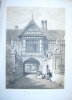
(Code No. 4217)
HALL, Samuel Carter.
(2 Antique Prints.)
Speke Hall, Lancashire.
London . Ca1850. Page size [14 1/2 x 11 ins.] 2 Lithograph plates of Speke Hall, Lancashire, taken from "The Baronial Halls, and ancient picturesque edifices of England". Slight foxing and marks to blank margins. £25.00
|
Click on picture above to view more images
How to order.
|
|
(Code No. 4209)17 Land Title Deeds for Liverpool and Everton.Dates 1845-65. Liverpool, England. Sizes (Approx) (660 x 560 mm) to (415 x 330 mm.) Many pages of hand written Land Title Deeds in a beautiful copper plate style, most on vellum parchments with elaborate initial lettering, regarding the disposal of parcels of land bordering Lilley St, Brunel St, Mackenzie St, Beltmont Rd , Avon St, Gregson St, Richard St, Lodge Rd, Long Hay, Edge Lane, Atherton St and Church St, Everton. West Lane and Birchfield Road. Some with hand-coloured ground plans. Royal stamps and signatories that include Marquis of Salisbury, Lord of the Manor of West Derby, John Holford, G. J. Christian, J. Hoskins, J. Shimmin and others, vg.
|
SOLD.
|
|
(Code No. 4168)William R. A. Daniell, [1769-1837]
View near lower Heysham, Lancashire.London. Longman & Co. 1816. Image size 9 1/2 x 6 3/4. Page size 14 x 9 1/2 ins. Original hand coloured aquatint, drawn and engraved by William Daniell.Taken from "A Voyage round Great Britain" No 41, Volume 2. William Daniell commenced a tour in a rowboat around Great Britain in the summers of the years 1813-16 starting and ending at Land's-End in Cornwall. As he went he drew a series of 308 hand coloured sketches illustrating the character and prominent features of the coast. During the winter times he returned home to produce watercoloures and aquatints.
|
SOLD
|
|
(Code No. 4114)Collier, John.The Miscellaneous Works of Tim Bobbin, Esq. Containing his view of the Lancashire Dialect, also, his Poem of the Flying Dragon, and the Man of Heaton.....London. Symons. 1806. 12mo, [4 x 7 ins]. Pp 12, xiv, 69, [40] [4] 145-203, 33 + 8 of 10 copper engraved plates, foxing spots throughout. Original half calf, rubbed with a slight splits to hinges. Holding firm.
|
SOLD.
|
|
(Code No. 4112)PYNE, W.H.Lancashire Illustrated, from Original Drawings by S. Austin, J. Harwood, and G & C. Pyne, etc.London: H. Fisher, 1831. 4to, [10 3/4 x 9 ins]. Engraved title + Additional title + pp 1-112 Text + 103 of 104 Steel engraved plates, (2 to a page), nicks to one plate + 13 Loose Extra illustrated Lancashire plates, some nicks to margins + Folding Liverpool town plan, (1860). Binding , poor.
|
SOLD.
|
|
(Code No. 4096)Perkins. George.
(10 Loose Antique Prints + 1 Oil Painting)Views of Old MANCHESTER.
1891. Page size (approx), 8 x 7 ins to the oil painting, 12 x 8 ins. Original lithographic prints by George Perkins, printed on boards, margins marked. Blackley Old Road, The Avenue Boggart Hale Clough, Charlestown, Valentine Brow, The Haunted house, Crumpsall Hall, Moston House, Croft House, Hough Hall and Lion Fold Farm + An oil painting of Heaton Park Smithy.
|
SOLD
|
|
(Code No. 4021)Toole, Millie.Mrs. Bessie Braddock MP. A Biography.London. Robert Hale Ltd. 1957. 4to. Pp 223. Illustrated throughout. Original cloth gilt. Dust jacket, chipping to edges.
Bessie Braddock was the first woman to be suspended from Parliament. Her entire political life was spent righting wrongs suffered in the Liverpool slums, at times with the help of a 2ft megaphone.
|
SOLD
|
|
(Code No.4020)Manchester Faces and Places.An illustrated record of the Social, Political, and Commercial Life of the Cotton Metroplois and its environs.5 Volumes.Manchester. J G Hammond. 1889-98. 4to, [6 1/2 x 9 1/2 ins]. Volumes 1, 3 , 4, 5 and 10. Pp approx 190 per volume, some slight wear throughout. Illustrated throughout showing shop fronts portraits, old Manchester, etc. Original half morocco, rubbed and wear throughout.
|
SOLD.
|
|
(Code No. 3907)Hope, E W.City of Liverpool. Handbook compiled for the Congress of the Royal Institute of Public Health. 1903.Liverpool. Lee & Nightingale. 1903. Folio, [ 9 1/2 x 11 1/2 ins.] Pp xi 330. Illustrated throughout, slight marginal marks, one plate with marginal nicks. Original decorated cloth gilt, rubbed with some surface loss to spine. In the early part of the 20th century, 16% of world tonnage of ships belonged to the port of Liverpool making it the 2nd city of the empire. This book deals with all aspects of the City of Liverpool, shipping, public buildings, public health, medical care, housing, transport, etc.
|
SOLD.
|
|
(Code No. 3906).Gore's Directory of Liverpool and its Environs, Including the Cheshire Side, New Brighton, Wallesey, Liscard, Seacombe, Bidston, Birkenhead, Tranmere, Oxton, Rock Ferry, Bebington, and Part of Eastham. 1874.Liverpool. J. Mawdsley. 1874. 8 vo, [ 7 x 10 1/2 ins.] Pp ix, [1], 1030, 164, 122, + Folding map, slight split at fold.An early directory on Cheshire and Liverpool. listing the principle towns and their history. Including the named residents and location, addresses of the trades and their adverts from the accountants to the woollen draper. Original cloth gilt with a crude taped spine.
|
SOLD.
|
|
(Code No. 3731).Marsh B.J. & S. Almond & P.W. Wolley.
2 Volumes.The Home Port. Bootle, the Blitz and the Battle of the Atlantic. & Bootle (Vol, 2).Sefton Council & S.B. Publications., 1993. 8vo & Folio, [8 1/2 x 11 1/2 ins.] Pp 72. 91. Illustrated throughout. Soft covers, Very good condition.
|
SOLD
|
|
(Code No. 3730).Liverpool. Bluecoat Press. 1998. Folio, [11 x 9 1/2 ins.] Pp 95. Illustrated throughout. Soft covers, Very good condition.
|
SOLD
|
|
(Code No. 3729).
Gahan, John W.
The Line Beneath the Liners & Seventeen Stations to Dingle.
2 Volumes.
Wirral, Countyvise Ltd, 1983. 1982. 8vo. Pp, 80. 88. Illustrated throughout. Soft covers, Very good condition. £18.00
|
How to order
|
|
(Code No. 3728).
Richardson. F, Andrew:
Well, I Never Noticed That. The Statues & Monuments of Liverpool & Bootle.
The Stories of who they were and what they did.
Liverpool.interprint.1999. 4to, [8 1/2 x 12 ins]. Pp. 98. Illustrated throughout. Soft covers, Very good condition. £20.00
|
How to order
|
|
Code No. 3727).Cook.Terry & Colin Wilkinson.The Streets of Liverpool & Scotland Road, "The Old Neighbourhood"2 Volumes.
The Bluecoat Press. Countryvise. 1993 & 2001. 4to. Pp 63,112. Illustrated throughout. Soft covers, Very good condition.
|
SOLD
|
|
(Code No. 3726).Bolger, Paul.The Docker's Umbrella - A History of Liverpool's Overhead Railway & Liverpool Overhead Railway.2 Volumes.Liverpool, The Bluecoat Press, 1992, 4to & 8vo. Pp 78, 63. Illustrated throughout. Soft covers, as new.
|
SOLD
|
|
(Code No. 3709).Saxton, Christopher & Guliel Hole.(AntiqueMap.).LANCASHIRE.
"Lancastriae comitatus palatinus".
London. Printed by Georgii Bishop & Joannis Norton. 1610. Image size 12 1/4 x 10 1/4 ins. Original copper engraved coloured map of Lancashire, engraved by Guliel Hole for Camden's "Britannia", 1610. Based on Saxton's map of 1577.
|
SOLD
|
|
(Code No. 3631).London. William Mackenzie. ca1867. 4to, 10 x 12ins. 2 Volumes in 4. Pp. 720, 464, cclx + 25 Steel engraved plates, vg. Original gilt decorated cloth, Spines faded and slight split to hinges. Still firm. Ex library, "Scarborough Philosophical and Archaeological Society" no stamps to text or plates. All edges gilt. Weight of Books, 10.5 Kg (approx).
|
SOLD
|
|
(Code No. 3623).
14 Photographs of the Building of the Liverpool Docks. (Loose).
Liverpool. ca1880. Image size (Approx), 10 3/4 x 8 1/4 ins. Page Size (Approx), 13 1/2 x 10 1/2 ins. 14 Photographs of the Liverpool Docks pasted on to thick card on both sides of the page. Shown:- Langdon Dock, Lighthouse, Alexander Dock, Engine House Langdon Dock, Canada Basin, Dock Entrance, Graving Dock Langdon, Engine House Langdon Dock, Foremen South Dock, Masonry of Dock Entrance, Shed Alexander Dock, Dock Wall Alexander Dock, Commencement of Herculaneum Dock, Herculaneum Dock & Petroleum Shore. £400.00
|
Click to view more images
How to order
|
|
(Code No. DP1451)Herdman, William Gawin:Pictorial Relics of Ancient LIVERPOOL Accompanied with descriptions of the antique buildings,etc.Liverpool. Subscriber's copy. 1857. Folio [ 385 x 295 mm.] Pp 107. Engraved title page, 48 lithograph view plates, some folding, slight foxing to some blank margins Original half calf. Gilt. Raised spine bands with gilt-tooled panels. Front cover detached, rubbed and faded. Marbled edges and end papers. The views shown include the view of Herculaneum pottery factory.
|
SOLD.
|
|
(Code No. DP3213)Buck. Samuel and Nathaniel.10 VIEWS OF LANCASHIRE + Large Double Page Panorama of the Town of LANCASTER. (As issued).London. Dates 1727, 1st edition.Print page size 18 x 11 ins. Image size 14 x 7 1/2 ins. Pp, Title page.The brothers, Samuel and Nathaniel Buck drew and engraved a series of etched panoramas and views of British towns, castles and abbeys etc. Each engraving describes below the image, the history of the castles, from Norman times to the early 18th century, including the numerous changes of ownership. Most prints show a dedication and coat of arms. Each print numbered from 1 to 10 in the left hand blank margin, signifying that they are the 1st edition, not the later 18th Century or early 19th Century reprints. Very good impression and condition. No Covers. Rare Copy.
|
SOLD.
|
| (Code No. 3438). Paris. Dembour & Gangel. Page size 21 1/2 x 14 ins. Image size 15 3/4 x 10 ins Original hand coloured copper engraved print, slight creasing and marks to blank margins. Guaranteed to bo over 200 years old. |
SOLD.
|
|
(Code No: 2817)BOWEN, EMMANUEL & THOMAS. KITCHIN. (Antique Map of LANCASHIRE.)"An Accurate Map of the County of LANCASTER; Divided into its Hundreds"London. Carington Bowles & Rob't Sayer. 1767. Map image size 20 1/2 x 26 ins . Copper engraved, coloured in outline, county map by Eman: Bowen. Title panel with a pictorial surround which includes cheeses, a woman shovelling grain into a sack held by a man and another man stoking a furnace, etc, with a Heraldic coat of arms below (Stanley Earl of Derby). A notable feature of the map is the space devoted to descriptive text in the form of the major town historical notes, "Seats of the Nobility" and "Explanation" (of the symbols on the map), spread over the map surface. Circular compass indicator, scale line and coloured graduated border, slight splits to folds, (No loss). The map is taken from the "Large English Atlas" Guaranteed to be over 200 years old.
|
SOLD.
|
|
(Code No.3384)
Grose. Francis, (ANTIQUE MAP) LANCASHIRE. London. ca.1780. Approx size 250mm x 170mm, Original copper engraved map, with descriptive text below the map. The map is a reprint of John Seller's map dated 1701, from [Camden's Britannia abridged, J. Wild].
Guaranteed to be over 200yrs old. £35.00
|
Click to view more images
How to order
|
| (Code No. 2643) Amsterdam, J. Hondius. 1616-39, French text . 95 x 135mm. Copper engraved map by S.Rogiers A much reduced version of Mercator's map of 1595. Superb ornate title and scale cartouches, watered-silk rendering of the sea. From the atlas - Petri Bertii's '"Tabularum Geographicarum Contractarum Libri septem" , A nick to outer border title letter, (not affecting map image area), Very Good Condition. |
SOLD
|
|
Return to top
|
|