SITE CONTENT
Antique Maps & Prints
Britain
Antique Maps - World
Antique Books
Cartographers
Early Prints
Other Stock
|
| Tallis Maps |
Images |
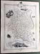
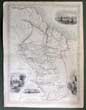
(Code No. 6818)
Tallis, John & John Rapkin.
(Antique Map).
Russia in Europe.
Date. (c.1850).
London & New York, J.Tallis. Page size [14 x 10 1/2ins]. Original steel engraved map with outline hand-colouring. Drawn and engraved by John Rapkin. Centre fold. Showing: - 7 Vignette scenes of St. Petersburg, Polish Captives on their way to Siberia, travelling sledge, etc. good condition...... £45.00 |
Click on picture above to view more images
How to order |
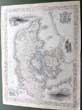
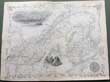
(Code No. 6819)
Tallis, John & John Rapkin.
(Antique Map).
Denmark.
Date. (c.1850).
London & New York, J.Tallis. Page size [14 x 10 1/2ins]. Original steel engraved map with outline hand-colouring. Drawn and engraved by John Rapkin. Centre fold.
Showing: - 6 Vignette scenes, Copenhagen, Sleswig and Elsinore Castle, horses, figures in traditional costume and a coat of arms. very good condition...... £35.00 |
Click on picture above to view more images
How to order |
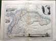
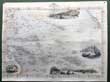
(Code No. 6816)
Tallis, John & John Rapkin.
(Antique Map).
Venezuela, New Granada, Equador, and the Guayanas.
Date. (c.1850).
London & New York, J.Tallis. Page size [14 x 10 1/2ins].Original steel engraved map with outline hand-colouring. Drawn and engraved by John Rapkin. Centre fold.
Showing: - 4 Vignette scenes of Paramaribo, Fall of Bagota, Chimborazo and a rural scene. very good condition........ £45.00 |
Click on picture above to view more images
How to order |
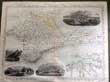
(Code No. 6814)
Tallis, John & John Rapkin.
(Antique Map).
The Crimea.
Date. (c.1850).
London & New York, J.Tallis. Page size [14 x 10 1/2ins]. Original steel engraved map with outline hand-colouring. Drawn and engraved by John Rapkin. Centre fold. Slight creasing.
Showing: - Vignette scenes of Banks of the Alma, Sevastopol, Balaklava Harbour, Eupatoria by John Rapkin. + Inset map of Sevastopol Harboour, very good condition....... £25.00 |
Click on picture above to view more images
How to order |
(Code No. 6813)
Tallis, John & John Rapkin.
(Antique Map).
British Guayana.
Date. (c.1850).
London & New York, J.Tallis. Page size [14 x 10 1/2ins]. Original steel engraved map with outline hand-colouring. Drawn and engraved by John Rapkin. Centre fold. Showing: - Vignette scenes of New Amsterdam, Ataraipu' or Devil's Rock, Christmas Cataract on the River Berbice, and Georgrtown by H. Winkles. very good condition....... £45.00 |
Click on picture above to view more images
How to order |
(Code No. 6812)
Tallis, John & John Rapkin.
(Antique Map).
East Canada and New Brunswick.
Date. (c.1850).
London & New York, J.Tallis. Page size [14 x 10 1/2ins]. Original steel engraved map with outline hand-colouring. Drawn and engraved by John Rapkin. Centre fold. Showing: - Large vignette scenes of Quebec, members of a native tribe. and Queen's medal. very good condition...... £45.00 |
Click on picture above to view more images
How to order |
(Code No. 6810)
Tallis, John.
[Antique Map.]
Polynesia, or Islands in the Pacific Ocean.
Date. (c.1850}.
London. J & F Tallis. Page size, [15 x 10). Original steel engraved map with original outline hand colouring. 4 vignette views.Kalakakoa Bay, site of Cook's death, Otahiti, Harbour of Doree New Guinea and Resolution Bay, Marquesas. Decorated border, centre fold, Slight nicks to to outer edges, one nick, approx, (1/2ins). John Tallis' maps are the last decorative, regional maps to be published....... £45.00 |
Click on picture above to view more images
How to order |
(Code No. 5893)John Tallis.Island in the Atlantic.[Antique Map.]Date. [c.1850].London. J & F Tallis. Page size, [15 x 10 1/2ins]. Original steel engraved map with original outline hand colouring. Six vignette views which includes Teneriffe, Madeira,. Decorated border. Centre fold. The map shows 4 inset panel maps, Bermudas. Canary Isles. Azores. Madeira......
|
SOLD.
|
(Code No. 5891)Tallis, John.[Antique Map.]POLYNESIA.Date. [c.1850].London. J & F Tallis. Page size, [15 x 10 1/2ins]. Original steel engraved map with original outline hand colouring. 4 vignette views. Decorated border, centre fold, vg. John Tallis' maps are the last decorative, regional maps to be published.......
|
SOLD.
|
(Code No. 5890)Tallis, John.Syria.[Antique Map.]Date. [c.1850].London. J & F Tallis. Page size, [15 x 10 1/2ins]. Original steel engraved map with original outline hand colouring. Four vignette views. Decorated border, vg. John Tallis' maps are the last decorative, regional maps to be published.......
|
SOLD.
|
(Code No. 5839)Tallis, John.[Antique Map.]CHANNEL ISLANDS.Date. [c.1850].London. J & F Tallis. Page size, [15 x 10 1/2ins]. Original steel engraved map with original outline hand colouring. 4 vignette views. Decorated border, Centre fold, vg.John Tallis' maps are the last decorative, regional maps to be published.......
|
SOLD.
|
(Code No. 5362)Hinton, John Howard.The History of the United States of America, From the Earliest Period to the Present Time..5 of 6 Volumes, lacks volume 4 .Date. [c.1850].London, J & F Tallis. 4to, [8 x 11ins.]Pp. 784 + 43 Steel engraved view plates of America + 8 Steel engraved Tallis maps of America, (colored in outline). Map list:- North America, Newfoundland and Nova Scotia, South America, United States, British America, East Canada, New Brunswick, & West Canada and Mexico California & Texas, very good condition. Original cloth gilt, slight rubbing. The British edition of this work is very rare...
|
SOLD.
|
(Code No. 5100)Martin, R. Montgomery (Robert Montgomery), 1803?-1868.THE BRITISH COLONIES; Their History, Extent, Condition, and Resources......4 of 5 Volumes. Lacks volume 5.Date. [c.1850.]London & New York, J & F Tallis, 4to, [8 x 11ins.] Approx, 380 pages of text per volume + 29 Double-page steel engraved Tallis maps, with original outline hand-colour & decorated with vignette views, very good condition + 28 Full-page plates, very good condition. List of Maps.Vol 1- World on Mecartor's Projection, Western Hemisphere, British America, North America, Nova Scotia or Newfoundland, Canada or New Brunswick, West Canada,Vol 2- Australia, Western Australia & Swan River, Part of South Australia, Victoria or Port Phillip, New South Wales, Eastern Hemisphere.Vol 3- Polynesia Islands in the Pacific Ocean,Van Diemen's Land or Tasmania, Falkland Islands, The World, New Zealand.Vol 4- Africa, slight damage, Western Africa, Natal and Kaffraria, Cape Colony, Jamaica, West India Islands, Islands in the Atlantic, South America, Central America, British Ghayana, Isthmus of Panama.Original half calf gilt, raised spine bands with gilt-decorated panels, rubbed with some slight surface loss.
|
SOLD.
|
(Code No. 4962)Martin, R. Montgomery (Robert Montgomery), 1803?-1868.THE BRITISH COLONIES; Their History, Extent, Condition, and Resources......5 Volumes, (Complete).Date. [c.1850.]London & New York, J & F Tallis, 4to, [8 x 11ins.] 40 Double-page steel engraved Tallis maps, (as listed), with original outline hand-colour & decorated with vignette views, very good condition + 31 Full-page portraits + 8 Full-page views, very good condition. List of Maps.Vol 1- World on Mecartor's Projection, Western Hemisphere, British America, North America, Nova Scotia or Newfoundland, Canada or New Brunswick, West Canada,Vol 2- Australia, Western Australia & Swan River, Part of South Australia, Victoria or Port Phillip, New South Wales, Eastern Hemisphere.Vol 3- Polynesia Islands in the Pacific Ocean,Van Diemen's Land or Tasmania, Falkland Islands, The World, New Zealand.Vol 4- Africa, Western Africa, Natal and Kaffraria, Cape Colony, Jamaica, West India Islands, Islands in the Atlantic, South America, Central America, British Ghayana, Isthmus of Panama.Vol 5- Asia, Overland Route to India, Thibet, Independent Tartary, British India, Southern India, Northern India, Cabool the Punjab and Beloochistan, Ceylon, Malay Archipelago, British Possessions in the Mediterranean.Original half calf over marbled boards, rubbed with some slight surface loss.
|
SOLD.
|
(Code No. 4536)Tallis, John.[Antique Map.]Date.
Ca1850.Syria. London. Page size 10 x 14ins. Original steel engraved
map with original outline hand colouring. Four vignette views.
Decorated border, vg. Centre fold, very good condition.
|
SOLD
|
(Code No. 4282)Tallis, John.Africa.(Antique Map )London. Ca 1850. Size Approx 330 x 255mm. Original steel engraved map. 5 vignette views, Decorated border, vg. split to fold, repaired on back of map.
|
SOLD.
|
(Code No. 4275)Tallis, John.(Antique Map of South Africa.)Natal and Kaffraria.London. Ca1850. Size Approx 360 x 275mm. Original steel engraved map with original outline hand colouring. Two vignette views that includes Port Natal and Durban. Decorated border. Centre fold.
|
SOLD.
|
(Code No. 4192)Tallis, John & J, Rapkin.(2
Antique Maps.)Comparative View of the Principal Waterfalls, Islands,
Lakes, Rivers and Mountains in the Eastern Hemisphere + Western
Hemisphere.London. John Tallis & Co. ca1850. Page sizes, [10 1/4 x 14 1/2 ins] 2 Original steel engraved maps, (one folding), drawn and engraved by John Rapkin. Taken from "Montgomery
Martin's Illustrated Atlas"
|
SOLD
|
London. Ca 1850. Sizes approx 360 x 275mm. 2 Original steel engraved maps with original outline hand colouring. Northern Africa with modern colouring to the vignettes. Decorated borders.
|
SOLD
|
<(Code No. 4073)Tallis, John.Part of South
Australia.[Antique Map.]London. Ca 1850. Size Approx 360 x 275mm.
Original steel engraved map with original outline hand colouring.
4 vignette views that includes Adelaide. Decorated border. Centre
fold.
|
SOLD |
(Code No. 4070)Tallis, John.Natal and Kaffraria.(Antique Map of South Africa.)London. Ca 1850. Size Approx 360 x 275mm. Original steel engraved map with original outline hand colouring. Two vignette views that includes Port Natal and Durban. Decorated border.
|
SOLD
|
(Code
No.3026)
London. Ca 1850. Size Approx 370 x 260mm. Original steel engraved
map with original outline hand colouring. Four vignette views.
Decorated border. Centre fold, vg. |
SOLD |
(Code No.3011)London. Ca 1850. Size Approx 360 x 275mm. Original steel engraved
map with original outline hand colouring. Three vignette views
which includes Hobart Town.. Decorated border. Centre fold, very
good.
|
SOLD |
(Code
No.3013)London. Ca 1850. Size Approx 360 x 270mm.
Original steel engraved map of New South Wales, Australia, with
original outline hand colouring. 3 vignette views, which includes
Sydney Cove and Pandanu the Murray. Decorated border. Centre fold,
vg.
|
SOLD |
(Code No.2250)London. ca1850. Size 20 3/4 x 15 ins. Original double page steel engraved
drawn and engraved by H. Winkles, the plan by
J.Rapkin + from Willamsburgh, The Narrow
from Fort Hamilton, Custom House, City Hall, Brooklyn, and a New York
Steamer. Decorative boarder. All streets, dock-yards areas and ferry
routes are listed, Slight foxing. |
SOLD |
(Code No.3016)Tallis, John.[Antique Map.]:
POLYNESIA.London. Ca 1850. Size Approx 370 x 260mm. Original steel
engraved map with original outline hand colouring. 4 vignette views.
Decorated border, Centre fold, vg.
|
SOLD
|
(Code no.3012)Tallis, John:British Possessions in the Mediterranean.
[Antique Map.]London. Ca 1850. Size Approx 360 x 275mm. Original
steel engraved map with original outline hand colouring. 6 Hand
coloured vignette views which includes Valetta, Gibraltar and Corfu.
(Modern colouring.) Decorated border. Centre folding.
|
SOLD.
|
(Code No.2292)London. ca1850. Page size 15 x 11 ins. Original single page steel
engraved drawn and engraved by J. Watkins, the
plan drawn by J. Rapkin +3 vignette views of State House, Bunkers
Hill Monument very good. |
SOLD |
| (Code No.3015)Tallis, John:West Canada [Antique
Map.]London. Ca 1850. Size Approx 360 x 275mm. Original steel engraved
map with original outline hand colouring. 4 vignette views which
includes Niagara Falls. Decorated border. Centre fold, vg. |
SOLD |
(Code No.3021)London. Ca 1850. Size Approx 370 x 260mm. Original
steel engraved map with original outline hand colouring. 3 vignette
views, one view showing the town of Lahore. Decorated border.Vg.
|
SOLD |
Code No.3022)Tallis, John:Africa. (Antique Map )London. Ca 1850. Size Approx 330 x 255mm. Original steel engraved
map. 5 vignette views, one view showing St Helena. Decorated border,
vg. Blank margins cropped to near engraved area.
|
SOLD |
(Code
No.3023)Tallis, John: [Antique Map.]Town Plan of Brussels. x 270mm. Original steel engraved town plan with original outline hand
colouring.Five vignette views that includes The Royal Palace, Hotel
de Ville. Decorated border. Centre fold, vg. |
<SOLD |
| (Code No.3024) London. Ca 1850. Size Approx 360 x 270mm.
Original steel engraved map with original outline hand colouring.
Seven vignette views that includes Cologne and Dresden. Decorated
border. Centre fold, vg. |
SOLD |
(Code No.3025)Tallis, John. (Antique Map):British Guayana.London. Ca 1850. Size Approx 370 x 260mm. Original
steel engraved map with original outline hand colouring. 4 vignette
views, one view showing the town of Lima. Decorated border. Centre
fold, vg.
|
SOLD.
|
(Code No.3026)
London. Ca 1850. Size Approx 370 x 260mm. Original steel engraved map with original outline hand colouring. Four vignette views. Decorated border. Centre fold, vg. |
SOLD |
(Code No.3029)Tallis, John. (Antique Map):Denmark.London. Ca 1850. Size Approx 360 x 275mm.
Original steel engraved map with original outline hand colouring.
4 Vignette scenes that includes Copenhagen. Decorated border, vg.
Centre fold.
|
SOLD.
|
(Code No.3030)London. Ca 1850. Size Approx 360 x 270mm.
Original steel engraved map with original outline hand colouring.
Four vignette views that includes Peths. Decorated border. Centre
fold. |
SOLD |
Return to top
|
|