SITE CONTENT
Antique Maps & Prints
Britain
Antique Maps - World
Antique Books
Cartographers
Early Prints
Other Stock
|
| Maps, Prints & Books of the North of England. |
Images |
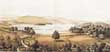
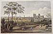
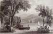
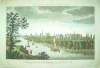
(Code No. 6924)
Anon.
(antique print).
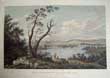
View of Derwentwater lake as seen from the south windows of Derwent Hill House.
Date. (c.1860).
Lake District, UK. Page size [16 x 11 1/4ins]. Image size [14 x 9ins]. Original chromolithographic print (coloured print).printrer's crease to image and slight nick to outer margin & centre fold......... £50.00. |
Click on picture above to view more images
How to order |
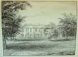
(Code No. 6831)
Hall. H.A.
(Framed Watercolour).
Steam Yacht Gondola on Lake Coniston, Lake District.
Date. (c.1900).
England. Frame size [15 x 12ins]. Image size [10 x 7ins].Original watercolour by H.A. Hall in its original wood frame.
On the back in pencil "the Gondola Pier Coniston" She was launched on 30 November 1859. and was 84 feet (26 m) long and registered to carry 200 passengers. The Illustrated London News of 7 July 1860 reported after her maiden voyage that the first class saloon was "beautifully finished in walnut wood and cushioned and decorated after the style of the royal carriages of our railways....... £150.00 |

Click on picture above to view more images
How to order |
(Code No. 6829)
Anon.
The Interchangeable Photo-Scrap Album.
Date. [c.1890].
London, 4to [8 x 9 1/2ins]. 79 Original Photographs of the environs of the Mersey & Yarmouth. Image sizes, [4 x 3ins]. Titles in pencil below images.
Listing: - (approx), 21 Liverpool and the River Mersey, 5 Fleetwood, 44 of the Yarmouth area + others views. Original cloth gilt, lack spine cloth. Holding firm. ......... £100.00 |
Click on picture above to view more images
How to order |
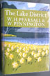
(Code No. 6756)
Pearsall, W. H. & Pennington, Winifred.
THE LAKE DISTRICT Landscape History.
New Naturalist No. 53.
Date. 1973, 1st edn.
London: Collins. 8vo [9 x 6 1/2ins]. Pp.320 + Illustrations throughout + Maps. Dust jacket in very good condition with publisher's plastic protective cover........ £30.00 |
Click on picture above to view more images
How to order |
(Code No. 6738)
Tattersall, George.
(Antique Prints)
Lakes Guides. Westmorland, Cumberland and Lancashire.
Date. 1836.
London. published by Sherwood and Co, Paternoster Row. Page size, (approx) (8 x 4 1/2ins). 27 Loose engraved prints. Engraved by W F Topham from the original draws by George Tattersall. Listing:- lakes and mountains named below images, foxing throughout. No text pages or covers. ..........£40.00 |
Click on picture above to view more images
How to order |
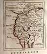
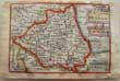
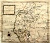
(Code no. 6674)
GROSE, Francis / Seller. J.
Map of CUMBERLAND.
(Antique Map).
Date. 1798.
London, Sold by H. H Symonds. Page size [7 x 10ins]. Original copper engraved map, The map is a reprint of John Seller's map Camden's Britannia abridged, J. Wild...
Francis Grose had shown a keen interest in drawing, having attempted sketches of medieval buildings as far back as 1749, and having taken formal instruction at a drawing school 1750s. He was not a particularly gifted draughtsman but he mixed in the London artistic group and began to exhibit, first at the Society of Artists in 1767-8 and then at the Royal Academy. His interest was in the field of medieval remains....... £25.00 |
Click on picture above to view more images
How to order |
(Code No. 6530)
Buckle, A.
Yorkshire etchings with sonnets and descriptions.
Date. 1885, Limited to 500 copies this being No. 388.
Leeds: Richard Jackson. Folio, [15 x 11ins]. 21 Etched plates with descriptive text, slight foxing. Original gilt decorated cloth. slight wear..... £55.00 |
Click on picture above to view more images
How to order |
(Code No. 6505)
Anno regni Georgii III. regis Magnae Britanniae,
THE MILITIA...
An Act for amending the Laws relating to the Militia in England, and for augmenting the Militia. Taken from the "Mess Room 3rd West York Militia".
Date. 1802.
London, Printed for George Eyre. 12mo, [4 1/4 x 7ins]. Pp. 216, [32]. Original full calf gilt, rubbed.
The 3rd Battalion of The York and Lancaster Regiment was formerly the 3rd West York Light Infantry Militia. The head-quarters were at Pontefract. By the last ballot for Militia precedence, the 3rd West York Militia became the premier Militia regiment of the United Kingdom. Its badge was the White Rose of York, and after it was made Light Infantry in 1852, a Bugle with the White Rose between the strings...... £90.00 |
Click on picture above to view more images
How to order |
(Code No. 6416)Cooke, G. A.Topographical and Statistical Description of the County of YORK; containing an account of its, situation, extent, towns, rivers, lakes...Date. [c.1820].London: C. Cooke for Sherwood Neely and Jones. 12mo, [4 x 6ins]. Pp. 350 [10 index] + 4 folding maps by J. CARY + 8 views on 4 pages, very good condition. Original half calf gilt over marbled boards, slight rubbing.....
|
SOLD.
|
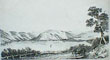
(Code No. 6414)
Farington, Joseph (1747-1821)..
(Antique print).
West View across WINDERMERE, looking over the GREAT ISLAND. From the Hill above the Ferry House.
Date. 1 April 1789.
London.Published W. Byrne. Page size [15 1/2 x 11 1/2ins] Image size [8 x 13ins].. . Original copper engraved print engraver by William Byrne (1743-1805) & J. Landseer.. Taken from an original drawing by Jos.h Farington R.A. Very good condition..... £60.00 |
Click on picture above to view more images
How to order |
(Code No. 6372)
Whittock, N.
6 Loose Yorkshire prints.
Date. 1847.
London: Fisher Son & Co. Page size, (approx), [11 x 8 1/4ins]. Image size, (approx), [6 x 4ins]. 6 Hand-coloured steel engraved prints of Yorkshire, engraved by W. J. Cooper and others, marginal foxing, not affecting coloured image.
Listing:- Ripon, York from the south east, Market place Hull, Halifax, Richmond, Otley Bridge, Wharfdale....... £55.00 |
Click on picture above to view more images
How to order |
(Code No. 6305)
Keere Van De.
(Antique miniature map).
DURHAM. "The Bishopprick of Durham"
Date. 1627.
London. Humble. George. Map image size [5 x 3 1/2ins]. Hand-coloured copper engraved miniature map of DURHAM by Van De. Keere, abridged from John Speed's The Theatre of the Empire of Great Britain. Title "DURHAM" and scale in an ornamental cartouche. Bottom left, the engraver's name, Back of map laid on to card. Sold as a working example only...... £40.00 |
Click on picture above to view more images
How to order |
(Code No. 6243)
William R. A. Daniell, [1769-1837].
Castle-head Westmoreland.
(Antique Print).
Date. Feb 1st, 1816.
London. Longman & Co. Image size 9 1/2 x 6 3/4. Page size, (approx). 14 x 9 1/2 ins. Original hand coloured mounted aquatint print, drawn and engraved by William Daniell, slight marginal marks. Taken from "A Voyage round Great Britain" No 43, Volume 2.
William Daniell commenced a tour in a rowboat around Great Britain in the summers of the years 1813-16 starting and ending at Land's-End in Cornwall. As he went he drew a series of 308 hand coloured sketches illustrating the character and prominent features of the coast. During the winter times he returned home to produce watercoloures and aquatints. .... £55.00 |
Click on picture above to view more images
How to order |
(Code No. 6195)
Rose, Thomas.
(Antique Prints).
Durham Illustrated.
Date. 1833.
London, Fisher, Son & Co. Page size, (approx) [8 3/4 x 6ins]. Image size, (approx), [6 x 4ins]. [c 1830]. 18 Loose steel engraved prints. No text or covers. Drawn by T. Allom. Engraved by W, Le Petit and others. Duplicates. Foxing mostly in the blank margins...... £25.00 |
Click on picture above to view more images
How to order |
(Code No. 6194)
Rose, Thomas.
(Antique prints).
Westmorland Illustrated.
Date. [c.1833].
London, Fisher, Son & Co. Page sizes (approx), [8 x 5ins]. Image sizes (approx), [4 x 6ins]. 138 Steel engraved view prints of Westmorland. Drawn by T, Allom. Engraved by W, Le Petit and others. Loose pages. No text or covers. Many duplicates. Slight foxing mostly in the blank margins. .....£120.00 |
Click on picture above to view more images
How to order |
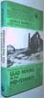
(Code No. 6139)
Raistrick, Arthur.
Lead Mining in the Mid-Pennines.
The Mines of Nidderdale, Wharfedale, Airedale, Ribblesdale, and Bowland .
Date. 1973.
Truro, D. Bradford Barton Ltd. 8vo, Pp. 172 + 16 plates + 13 diagrams. Original cloth gilt. Dust jacket, very good condition....£35.00 |
Click on picture above to view more images
How to order |
(Code No. 6120)Postlethwaite, John & Harris, A.2 Volumes.Mines and Mining in the Lake District & Cumberland Iron.The Story of Hodbarrow Mine 1855-1968. Monographs on Mining History No. 2.Date. 1970 & 1983.Whitehaven, Michael Moon & Truro, D. Bradford Barton Ltd. 8vo, Pp. [8] 164, [9] + Illustrations & maps throughout. Original cloth gilt. Dust jacket, price clipped. Pp.122, [1] + Illustrations & maps throughout. Original cloth gilt. Dust jacket, price clipped........
|
SOLD.
|
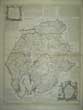
(Code No. 6046)
BOWEN, Emanuel & Kitchin Thomas.
(Large Antique Map).
An Accurate Map of CUMBERLAND & WESTMORELAND.....
Date. [c.1760].
London, T Bowles, Robert Sayer, and John Bowles. Page size [30 x 23ins].Original outline hand-coloured copper engraved double page map. Scale about 4 miles to 1 inch, The largest of the county map to date and incorporating many new details, but also introducing some curious errors. The degrees of longitude (West of London) are about 2 degrees out and the main body of the counties are too wide from east to west. They show towns with their market days, villages (with indications to show whether rectory or vicarage), religious houses, charity schools, castles, hundreds, hills, parks, forests, sands, meres, rivers, brooks, post roads with measured distances between the towns, and several other roads now shown for the first time. Numerous descriptive notes are scattered around the map. A circular compass indicator. The title with the imprint below, scale, "Explanation" (of the symbols on the map), and the dedication. The titles have a pictorial surround;
Thomas Kitchin was an engraver and publisher at The Star opposite Ely Gate, Holborn, and London from 1738 to 1776. He was a prolific producer of maps, plans and charts, and was by appointment Hydrographer to the King - George III. His output included sheet maps, series of maps for the Universal Magazine and the London Magazine, and atlases. He worked with Thomas Jefferys and particularly with Emanuel Bowen....... £200.00 |
Click on picture above to view more images
How to order |
(Code No. 6040)KEERE, Pieter van den.(Antique Map).Northumberland.Date. 1627. London. Humble. George. Map image size [5 x 3 1/4 ins]. Copper engraved miniature map of Northumberland by Van De. Keere, 2 brown marks and cropping to outer boarder. English text on the back of map. Abridged from John Speed's The Theatre of the Empire of Great Britain. vg. Guatanteed to be over 350 years old.
|
SOLD.
|
(Code No. 6027)Moule, Thomas.(Antique Map).DURHAM.Date. [1836 -52.] London. Virtue. Page size 10 3/4 x 8 1/2ins. Original steel engraved county centre fold map of DURHAM, nicks to outer margins strengthened on back of map. Decorated with two vignettes, Raby Castle and Durham. Ornamental border with symbolic figures woven into the design, heraldic coat of arms. Moule's county maps are the last series of decorative maps to be published. Guaranteed over 140 yrs old. .....
|
SOLD.
|
(Code No. 6002)
Ogilby. John.
( Antique Strip Road Map).
The Road from LONDON to CARLISLE, Number 37.
Showing section - Darleston, Newcastle under Line, Brewerton, Gridham, Warington, Newton, Wigan, Whittle ending at Preston.
Date. 1675 - 98.
London. Page size, (approx), [ 18 1/4 x 15 ins ]. Image Size [ 16 x 13 ins ]. Original copper engraved Strip Road Map, (modern colouring), slight creasing and 2 marginal nick just outside engraved area . Each map strip shows towns, villages, mansions with owner's name, castles, wind mills, beacons, gallows, woods, rivers, and hills etc. Elaborate title cartouche and compass roses to each map strip.
John Ogilby was a topographer, printer, and map-maker, born in Edinburgh, EC Scotland, UK. A dancing teacher and theatre owner, he lost everything in the Civil War, but after the Restoration obtained court recognition and became a London publisher. The great fire of 1666 destroyed his stock but got him the job of surveying the gutted sites in the city. He established a thriving printing house and was appointed 'king's cosmographer and geographic printer'. His most important publications were engravings of maps and atlases, including Africa (1670), America (1671), and Asia (1673), and a road atlas "Britannia" (1675), unfinished at his death. He was also the first cartographer to adopt the statute mile. Scale 1inch to the mile, each mile is divided into furlongs indicated by dots in the centre of the road. Guaranteed to be over 300 years old....... £130.00 |
Click on picture above to view more images
How to order |
(Code No. 5997)Jenner, Thomas.(Antique map).CUMBERLAND.Date. 1643. London, Sold by Thomas Jenner. Image size, (approx), [4 x 4ins]. Original copper engraved map, (modern colour), very good condition.The map in an inclined position has been squeezed into the triangular space below the distance table. It shows rivers, towns (with the names spelt in full) and some hills. A pair of dividers measures off the new scale of 10 miles (= 7 /16ins.). It was thought the maps were used by Oliver Cromwell's Parliamentary Army during the English Civil War........
|
SOLD.
|
(Code No. 5989)Hyde, W.G.S.The Manchester, Bury, Rochdale and Oldham Steam Tramway.Date. [c.1979].Glossop: Transport Publishing. 8vo, [6 3/4 x 9 1/2ins]. Pp. 104 + Illustrated throughout + folding map. Original coloured pictorial laminated boards, fine condition.The tramway was conceived solely for the financial gain of its London backers; its beginnings were tortured by a maze of legal technicalities, each one designed further to line the pockets of its promoters; and its career was marked by a succession of Court cases.......
|
SOLD.
|
(Code No. 5952)Hoole K.NORTH ROAD LOCOMOTIVE WORKS DARLINGTON 1863 - 1966.Date. 1967. Middlesex, Roundhouse Publishing Ltd. 8vo, [6 1/4 x 9 1/4ins]. Pp.102 + Illustrations throughout. Original cloth gilt, very good. Dust jacket, very good.Ken Hoole carefully gathered together the official records at York and Darlington and traced the growth of North Road from its establishment under the Stockton and Darlington Railway in 1863 through its L.N.E.R. heyday under Gresley, Thompson and Peppercorn, to its demise under B.R. in 1966.......
|
SOLD.
|
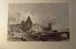
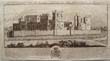
(Code No. 5879)
Robson, G.F.
(Antique print).
South West View of Durham Cathedral and Castle.
Date. July 1st. 1809,
London, published by G.F. Robson, 25, Parliament Street. Page size, [23 1/2 x 15ins]. Original hand-coloured aquatint print, with modern mount.. Lacking title, publisher's address & cropped to image, slight foxing & creasing...... £110.00 |
Click on picture above to view more images
How to order |
(Code No. 5821)Buck, Samuel & Nathaniel.The Castles, Abbeys, and Priories, of The County of CUMBERLAND.Including the City of Carlisle, delineated as they stood in 1739.Date. 1837, 3rd edition .Carlisle, Hudson Scott. Oblong folio, [17 1/2 x 11ins]. Title, Preface and List of plates, damaged with crude tape + 18 Copper engraved view prints, (as listed), each with descriptive text, slight marginal foxing. The loose panorama of the City of Carlisle, split to fold, repaired.The brothers, Samuel and Nathaniel Buck made a series of etched panoramas and views of British towns, castles and abbeys. These engravings describe the history of the castles from Norman times and the numerous changes of ownership. Original printed boards, surface loss. The publishers used the original Buck copper plates for this work......
|
SOLD.
|
(Code No. 5805)
Cary, John.
(Antique Map).
County map of East Riding of Yorkshire.
Date. 1st Sep' 1787. 1st edition.
London. John Cary, Arundel Street. Page size [13 x 9 1/2ins]. Original copper engraved hand-coloured map, marks to blank margin, not affecting the engraved area.
Taken from John Cary's atlas, New and Correct English Atlas. Beautifully engraved map showing towns, villages, parks, forests, (with each mile numbered) and secondary roads, rivers and canals.. This map repeats Bowen's error of 1751. Cary introduced a new high standard of draughtsmanship and engraving which, coupled with improved cartographical material (due to the numerous recent large-scale surveys of the counties) being available, made this map a great advance on any previous work of its kind...... £35.00 |
Click on picture above to view more images
How to order |
(Code No. 5760)Watkins, George.The Textile Mill Engine.2 Volumes.Date. 1970.Newton Abbot, David & Charles Library of Textile History. 4to, Pp. 120, 112 + Illustrations throughout. Original cloth gilt. Dust jackets,
|
SOLD.
|
(Code No. 5700)
Smith ,T of Derby.
(Antique Print).
Gordal, at Malham in Craven, Yorkshire.
The waters collected in a Sudden Thunder Shower about 18 years ago, burst a Passage thro: the Rock.......
Date. [c.1750].
England [no name of publisher], Size [15¼ x 21¼ ins]. Etching with some engraving. Lettered below image with description and dedication to Thomas Lister of Gisburn Park by the painter, production detail: "T. Smith Pinx of Derby ", "J. Mason Sculp." and "Publish'd Decr. 1751?"
View of a Gordale Scar, a rocky gorge with a waterfall, a country boy leading two gentlemen with fishing rods on the rocks at right. Damaged, sold as a working copy only.......£90.00 |
Click on picture above to view more images
How to order |
(Code No. 5647)NELSON, T. H.THE BIRDS OF YORKSHIRE, Being an Historical Account of the Avi-Fauna of the County.2 Volumes.Date. 1907 1st edn.London: A. Brown & Sons. 8vo, [8 3/4 x 6ins].... Pp xlv 1- 374. xii 375-843. 2 Colour frontis, Illustrated throughout. Original cloth, vg. No D/j ....
|
SOLD.
|
(Code No. 5645)
Greenwood, Christopher and John.
(Large Antique Map).
Map of the County of Cumberland from an actual survey made in the years 1821 & 1822. Published 1830.
Date. April 10th 1823,
London: George Pringle Jr. Map size, (approx) [60 x 73ins]. Large hand-coloured steel engraved map, on the original wood & metal roller, backed on linen, darkened area towards base of map surface.
Christopher (1786-1855) and John Greenwood (fl.1821-1840) were brother cartographers who produced large-scale maps of England and Wales in the 1820s. Their partnership began in 1821, using the imprint "C.&J.Greenwood".The Greenwoods' intention was for a series of maps of the whole country at a one inch scale. They did not achieve this, largely because of competition from the newly-founded Ordnance Survey, but their output includes superb maps that were finely drafted and elegantly engraved. Between 1817 and 1830 they produced a series of splendid large-scale folding maps of most of the counties based on their own surveys...... £550.00 |
Click on picture above to view more images
How to order |
(Code No. 5612)Nelson T & Son.The English Lakes in The Neighbourhood of Ambleside.Date. [c.1870.]London. Nelson T & Son.12mo, [6 1/2 x 4ins]. Pp,24. 12 Printed coloured engraved plates. Ink dedication on flyleaf. Original embossed cloth, gilt. Glazed decorated title label, slight wear.....
|
SOLD.
|
(Code No. 5591)
Buck, Samuel (& Nathaniel).
( Antique Print.)
The South-East view of RABY CASTLE, in the Bishoprick of Durham.
Date. 1728,1st edition.
London. Image size 14 x 7 1/2ins. Original copper engraved print drawn and engraved by Samuel & Nathaniel Buck, nick affecting the engraved surface, (1inch).
The brothers, Samuel and Nathaniel Buck drew and engraved a series of etched panoramas of British towns, castles and abbeys etc including the history of the castles. Print numbered 7 in the left hand blank margin, signifying that it is the 1st edition, not the laterer 18 Century reprints. The castle was begun by John, 3rd Baron Nevill in approximately 1360. Cecily Neville, who was the mother of the Kings Edward IV of England and Richard III of England was born here. The Nevilles lost the castle (and many more of their possessions) after they led the failed Rising of the North in favour of Mary, Queen of Scots in 1569. .... £35.00 |
Click on picture above to view more images
How to order |
(Code No. 5586)St. John Hope, W.H.FOUNTAINS ABBEY , Yorkshire.( With a Signed letter by the Author ).Date. 1900.Leeds. J. Whitehead & Son. 8vo, [ 6 x 9¾ ins ]. Pp 134 + Folding plan + Large folding coloured plan in rear pocket. Including text illustrations throughout. Original printed boards, slight fading to edges. Included a signed letter from the author to a Mr. A. Hamilton Thompson regarding churches.....
|
SOLD.
|
(Code No. 5582)BROWNE, John, of York.Reliquiæ antiquæ: or, a Series of etchings, representing remains of architecture and sculpture, in the county of York ... Drawn and etched by J. Browne. no. 1.Date. 1823.York : The Author. 4to [10 x 14ins]. Pp.4 + 4 Drawn & Etched prints by John Browne. Original printed soft covers, slight marks.The prospectus for this work states that the publication numbers shall take place every six months. Unfortunately for whatever reason only this number 1 issue ever appeared. Very rare, no other copy found in private ownership....
|
SOLD.
|
(Code No. 5529)
Wildridge, T. Tindall.
Holderness and Hullshire Historic Gleanings, a portfolio of pictures, poetry and prose.
Date. 1886.
Hull, Wildridge & Co. 4to, [8 x 10ins]. Pp. xi. 143 + Full-page and text plates throughout, subscriber's library list on front past down. (no stamps). Decorated covers with crude later spine. Lists:- Family Genealogy, social life of Hull and Humber, topography, coats of arms, principle towns, etc.... £50.00 |
Click on picture above to view more images
How to order |
(Code No. 5245)HEATON, COOPER. W.THE HILLS OF LAKELAND.Date. 1938, 1st edn.London, Frederick Warne . 4to, Pp.xviii, 126 + 16 colour plates and 36 monochrome and 2 maps, very good. Original cloth gilt. Dustjacket price clipped and slight nicks to outer edges.
|
SOLD.
|
| (Code No. 4967)(Trade Directory)Kelly's Directory of DURHAM. 1929.Date. 1929.London, Kelly's Directories Ltd, Large 8vo, [7 1/4 x 10ins.] Pp ix 592, [2]. Large folding coloured map, closed split (no loss) + Full-page map of the "Table of Strata", very good. Original cloth, spine faded.
|
SOLD.
|
| (Code No. 4966)
Ward's Directory of Darlington, Hartlepool, West Harlepool with their Adjacent Villages.1931-32.Date.
Date. 1931.
Newcastle-on-Tyne, Ward & Sons. 8vo, [9 x 6ins.] Pp.[1], 367, [pp.1, adverts], last page of adverts damaged. Original cloth gilt, marked and cloth hinges split. Holding firm. Listing, Trades index to advertisments, County guide, Streets and lanes, street keys, Almanac, etc....£65.00
|
Click on picture above to view more images
How to order
|
| (Code No. 4965)Ward's Directory of Darlington, Hartlepool, West Harlepool, Middlesbrough, Stockton and Thornaby.1904-05.Date. 1904. Newcastle-on-Tyne, Ward & Sons. 8vo, [8 1/2 x 6ins.] Pp.[1], 698, [1],(48 adverts). Original cloth gilt, slight marks and rubbing. Listing, Trades index to advertisments, County guide, Streets and lanes, street keys, Almanac, etc.
|
SOLD.
|
(Code No. 4964)Ward's Directory of Darlington, Hartlepool, West Harlepool, Middlesbrough and Stockton.1917-18.Date. 1917. Newcastle-on-Tyne, Ward & Sons. 8vo, [9 x 6ins.] Pp.[1], 676, [1]. Original cloth gilt, slight marks and rubbing. Listing, Trades index to advertisments, County guide, Streets and lanes, street keys, etc.
|
SOLD.
|
| (Code No. 4898)
Osborne, Thomas.
A Correct Map of Cumberland.
Date. 1748.
London. Printed for S. Burt. Page size, 8 x 7ins. Original copper engraved map with outline colour, browning & one very small worm hole, repaired. Taken from "Geographia Magnae Britanniae" Rare Map. £45.00
|
Click on picture above to view more images
How to order |
| (Code No. 4828)Boyle, J. R.The County of Durham: Its Castles Churches and Manor-Houses. With an Essay on the Place-Names of the County and a Glossary of the Names.Date. [c.1892].London. Walter Scott Ltd. 4to, [8 x 10ins.] Large Paper Edition, limited to 250 numbered copies. No. 178. Pp viii, 724, xxxvi + 2 Large folding maps + illustrations, very good. Original trade boards gilt, rubbed. Top edge gilt. others untrimmed.
|
SOLD.
|
| (Code No. 4822)BACON, George Washington, and Co.Bacon’s Excelsior Map of Yorkshire, and parts of adjoining Counties. Showing Railways, Roads, Elevations & Distances....+ Index-Gazetteer & Geological Map of Yorkshire.No date, [c.1900.] Manchester. G. W. Bacon & Co. Ltd. . Map size, [35 by 45.5 ins,] folding to, 4to, [7 1/2 x 9ins.] Original linen backed folding sectional coloured engraved map, very good. Scale of 3 miles[ = 1 inch]. Original cloth gilt, spine cloth, worn.
|
SOLD.
|
| (Code No. 4804)Moule, Thomas.Cumberland.(Antique Map, Guaranteed over 140 yrs old ).Date. [1836 -52.]London. Virtue. Page size 10 3/4 x 8 1/2ins. Original steel engraved county map of Cumberland. marked to fold area and strengthened fold on back of map. decorated with vignettes, view of Carlisle. Ornamental border with symbolic figures woven into the design, heraldic coat of arms. Moule's county maps are the last series of decorative maps to be published.
|
SOLD.
|
(Code No. 4795)Moule, Thomas.DURHAM. (Antique Map, Guaranteed over 140 yrs old ).Date. [1836 -52.]London. Virtue. Page size 10 3/4 x 8 1/2ins. Original Steel engraved county map of DURHAM. marked to fold area & strengthened on back of map. decorated with two vignettes, Raby Castle and Durham. Ornamental border with symbolic figures woven into the design, heraldic coat of arms. Moule's county maps are the last series of decorative maps to be published.
|
SOLD.
|
(Code No. 4498DP)Buck. Samuel and Nathaniel.(10 Antique Prints of Northumberland.)Norham Castle, Brinkbury Priory, Tinemouth Monastery & Castle, Prudhoe Castle, Bothal Castle, Chillingham Castle, Dunstanburgh Castle, Belso Castle, Horton Castle,and Widdrington Castle .All Dated. 1728, 1st edition, not the later 18th century reprints.Page size 18 x 11 ins. Image size 14 x 7 1/2 ins.11 Original copper engraved prints. South East view of Norham Castle, South West view of Brinkbury Priory, North view of Tinemouth Monastery & Castle, South view of Prudhoe Castle,
North view of Bothal Castle, West View of Chillingham Castle, South West view of Dunstanburgh Castle, South view of Belso Castle, South East view of Horton Castle, and East view of Widdrington Castle .
The brothers, Samuel and Nathaniel Buck made a series of etched panoramas and views of British towns, castles and abbeys. The engravings describes, below the image, the history of the castles from Norman times, including the changes of ownership + dedications and coat of arms. Willing to sell individual prints.
|
SOLD.
|
| (Code No. 4227)
Burlington, Charles:
View of the City of York from the River Ouse.
Date, 1779.
London. Size [12 x 8 1/4 ins.] Original copper engraved coloured print of the City of York, (modern colouring). Taken from "The Modern Universal British Traveller". £35.00
|
Click on picture above to view more images
How to order |
| (Code No. 4221)Geographia Plan of Leeds, Yorkshire. London. Geographia. No Date, ca1930. Size [39 x 44 ins.] Folding coloured linen backed plan of Leeds, Yorkshire, very good condition. Scale 1 inch to 1/4 mile.
|
SOLD.
|
| (Code No. 4220)20 ORDNANCE SURVEY MAPS .(Early 20th Century, 1st reprint maps of Yorkshire.)Southampton. Ordnance Survey Office, Map sheet approx sizes (42 x 29 ins). 20 + 3 odd Photozincographed Ordnance Survey maps of Keighley Edition of 1934, sheet clxxxvi.13.- Shipley. Edition of 1919, sheet cc.12. - Bingley, Edition of 1891, sheet cci.6.6.- Shipley.
Edition of 1933, sheet cci.13.- Shipley. Edition of 1934, sheet cci.11.- Shipley. Edition of 1921, sheet cci.2.- Keighley Edition of 1891, sheet cci.6.2..- Airedale. Edition of 1893, sheet cci. 11, large split.- Wharfedale. Edition of 1921, sheet clxxxvi.8.- Wharfedale. Edition of 1934, sheet clxxxvi.12..- Shipley.
Edition of 1891, sheet cci.12.7.- Wharfedale. Edition of 1921,sheet clxxxvi.16..- Wharfedale..Edition of 1921,sheet clxxxvii.5..- Wharfedale/Esholt . Edition of 1908, sheet cci.8..- Keighley. Edition of 1919, sheet clxxxvi.13.- Keighley. Edition of 1919, sheet cc.12.. - Shipley.
Edition of 1933, sheet cci.5.- Airedale Edition of 1922, sheet cci.7..- Bingley. Edition of 1919, sheet clxxxvi.14.- Hawksworth. Edition of 1908, sheet cci.4. Scale 208 & 40 feet to one inch. Some nick to margins no loss.
|
SOLD.
|
| (Code No. DP4090)Bowen, Emanuel, John Owen, & John, Ogilby.(Antique Map & Strip Road Map.)DURHAM.London.
T, Bowles. King of Spain. 1720-64.. Size of page, 6 x 8 ins. Original
copper engraved County map + strip road map, both taken from "Britannia Depicta or Ogilby Improv'd",
very good condition
|
SOLD.
|
Return to top
|
|