SITE CONTENT
Antique Maps & Prints
Britain
Antique Maps - World
Antique Books
Cartographers
Early Prints
Other Stock
|
| Maps, Prints & Books of Wales |
Images |
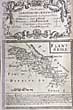
(Code No. 6921)
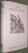
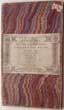
Jenkinson, Henry Irwin.
Jenkinson's Practical Guide to North Wales with the Chester Section.
Date 1878.
. London, Edward Stanford. 12mo [4 x 6 1/2ins]. . Pp.77 + Folding map, slight nick no loss. Full leather, spine with surface loss and loose hinges. .......£30.00 |
Click on picture above to view more images
How to order |
(Code No. 6911).
Owen, J and E, Bowen.
( Antique miniature map).
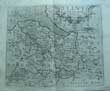
DENBIGHSHIRE.. (Pages 183 & 181).
Date. 1720 or later edition.
London. Tho, Bowles. Page size [5 1/2 x 8ins]. . Original copper engraved map of Denbignshire & strip map of Glocester to Coventry. Printed back to back on single sheet, Taken from "Britannia Depicta" a more handy version of John Ogilby's Survey of 1675......... £25.00 |
Click on picture above to view more images
How to order |
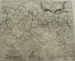
(Code No. 6877)
Owen, J and E, Bowen.
( Antique Map.).
Flintshire (Pages 265 & 266).
Date. 1720 or later edition.
London. Tho, Bowles. Page size 5 1/2 x 7 1/2ins. .. Original copper engraved map & strip map. Printed back to back on single sheet, Taken from "Britannia Depicta" a more handy version of John Ogilby's Survey of 1675.......... £25.00 |
Click on picture above to view more images
How to order |
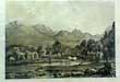
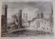
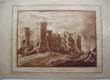
(Code No. 6848)
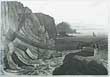
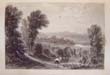
William R. A. Daniell, [1769-1837].
(Antique aquatint print).
View near Aberystwyth. Cardiganshire.
Date. 1st, Nov, 1814.
London. Longman & Co. Image size 9 1/2 x 6 3/4. Page size 15 x 11ins. Original aquatint, drawn and engraved by William Daniell. Taken from "A Voyage round Great Britain" No. 20, Volume 1. Very good condition.
William Daniell commenced a tour in a rowboat around Great Britain in the summers of the years 1813-16 starting and ending at Lands'-End in Cornwall. As he went he drew a series of 308 hand coloured sketches illustrating the character and prominent features of the coast. During the winter times he returned home to produce watercoloures and aquatints. A magnificent series of plates, almost all of equal quality. Valuable as a record and exquisite in its presentation. It is the most important plate book on British Topography........ £45.00 |
Click on picture above to view more images
How to order |
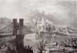
(Code No. 6835)
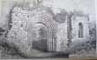
Pritchard, W.
BEDDGELERT. Carnarvonshire, North Wales.
(Antique Print).
Date. (c.1840 ).
Carnarvon, Printed & Published by W. Pritchard. Page size (13 x 10ins). Image size 10 1/4 x 7 1/4ins] Original Lithographical engraving, Split to top edge, (approx) 1ins into engraved area. Beddgelert is a village and community in the Snowdonia area of Gwynedd, Wales. The population of the community taken at the 2011 census was 455. It is reputed to be named after the legendary hound Gelert. ........£25.00 |
Click on picture above to view more images
How to order |
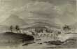
(Code No. 6825)
Gardner. Thomas.
(Antique Map).
The road from Welshpool to Montgomery and on to Carnarvon in North Wales.
Date. 1719.
London, J. Tonson & J. Watts. Page size [11 1/2 x 7 1/2ins]. Original copper engraved strip road map from Welshpool to Llanvair (Llanfair Caereinion) to Dinas mouthy to Dolgetha (Dolgethe) to Llandura (Llanbeder) to Harlech to Dalbenmer (Dolbenmaen) to Carnarvon (Caernarfon)..Include rivers, ponds, churches, windmills, blacksmiths forges, gallows and bridges etc. Dedicated to "the Honourable Edward Vaughan Esq. Very good condition....... £55.00 |
Click on picture above to view more images
How to order |
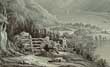
(Code No. 6767)
William R. A. Daniell, [1769-1837]. (2 Antique Prints).
Part of the South Stack Holyhead & The Rope Bridge near the Lighthouse Holyhead. (North Wales).
Dates, April 2nd & Feby 2nd, 1815.
London. Longman & Co. Image size [9 1/2 x 6 3/4ins]. 2 Original engraved aquatints, drawn and engraved by William Daniell. Taken from "A Voyage round Great Britain" Volume 1. Nos 25 & 26.
William Daniell commenced a tour in a rowboat around Great Britain in the summers of the years 1813-16 starting and ending at Lands'-End in Cornwall. As he went he drew a series of 308 hand coloured sketches illustrating the character and prominent features of the coast. During the winter times he returned home to produce watercolours and aquatints. A magnificent series of plates, almost all of equal quality. Valuable as a record and exquisite in its presentation. It is the most important plate book on British Topography....... £70.00 |
Click on picture above to view more images
How to order |
(Code No. 6736)
(M'Lean. Thomas).
A Picturesque Description of NORTH WALES: embellished with TWENTY SELECT VIEWS from Nature.
Date. 1823.
London. Thomas McLean. Oblong 4to, [ 11.4 x 8.4 ins ]. Lacking half-title? Title-Page (v.blank) + Preface 1 p + List of Plates 1p. (v.blank) + 20 ORIGINAL HAND COLOURED AQUATINTS, each with a descriptive text. very good condition. Modern half calf gilt with original gilt morocco title label, with owner's book plate on front past down. Marbled boards.
Views shown:- Flint Castle, The Vale of Clydd, The view of the Dee near Corwen, View of the River Conway, Conway Castle, Caernarvon Castle, Dolbadron Castle, Llanberris Lake, Moel Shabod, Nant Gwynant, Llyn-y-Dinas, River Glass Llyn, Mountain of Cnight, Head of the Vale of Festiniog, Rhaiadr-y-Mawddach, Dolgelly Bridge, Bala Lake, Tal-y-Llyn, Goodrich Castle and Interior of Goodrich Castle..... £1100.00 |
Click on picture above to view more images
How to order |
(Code No. 6723)
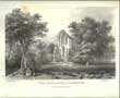
Williams. Stephen W.
The Cistercian abbey of Strata Florida : its history, and an account of the recent excavations made on its site.
Date. 1889.
London, Whiting and Co. 8vo, [6 x 9ins]. Pp. vii, [2], 229, cxxxvii + Many plans & maps throughout. Original cloth gilt, slight rubbing....
Around 1164 the Abbey of Strata Florida was founded through the patronage of Rhys ap Gruffydd. Strata Florida Abbey was dissolved in 1539 by Henry VIII's church commissioners. Stephen Williams, who was to become a leading expert on the archaeology of the Cistercian Order, was placed in charge of an excavation. Over the next few years, Williams removed huge amounts of spoil, to uncover the majority of remains that are still on view today. Interest in the Strata Florida's ruins brought in many wealthy Victorians....... £50.00 |
Click on picture above to view more images
How to order |
(Code No. 6718)
Birch, Walter de Gray.
History of Margam Abbey.
Date. 1997, Facsimlie Edition, Reprinted from 1897 edition.
West Glamorgan Archive Service, Glamorgan. 4to, [ 8 x 10 14ins]. P. xvi, viii 405 + Illustrations throughhout. Limited Edition, number 292 of 400 copies. Original cloth gilt, fine condition. Dust jacket, fine condition.
Margam Abbey was a Cistercian monastery, located in the village of Margam, a suburb of modern Port Talbot in Wales. The abbey was dissolved by King Henry VIII of England in 1536 and sold to Sir Rice Mansel. Significant holdings of the monastery library appear to have survived this event, including the Annales de Margan. At this time, only 12 monks were living in the monastery. From the Mansel family the abbey eventually passed into their descendants in the female line, the Talbot family. In the 19th century, C R M Talbot constructed a mansion at Margam Castle which overlooks the abbey ruins. The nave of the abbey continued in use as the parish church, as it does to this day....... £45.00 |
Click on picture above to view more images
How to order |
(Code No. 6717)
Peate, lorwerth. C.
The Welsh House: A Study in Folk Culture.
Date. 1946.3rd edn.
Published by Liverpool: Hugh Evans & Sons Ltd The Brython Press. 8vo, [9 x 5 1/2ins]. Pp. xviii, 204 + 86 Photographs + Plans, etc. Original cloth, very good condition. Dust jacket, splits to edges....... £35.00 |
Click on picture above to view more images
How to order |
(Code No. 6572)Dew, M W. & Son & others (Auctioneers).(Sale Catalogue).County of Anglesey, Plas Newydd Estate in the Parish of Llandysilio and Llanfairpwll. Pier Pavilion, Menai Bridge.Date. 1932.Folio, [10 x 15ins]. Monday, May 9th, Pp. 36, [4] + Folding map of the Plas Newydd Estate, Menai Bridge and Surrounding District..Catalogue listing 62 lots:- Freehold Residences, Business Premises, Accommodation Land, Small Holdings, Cottages & Building Land. Printed soft covers, Lacks half of rear blank cover......
|
SOLD
|
(Code No. 6571)HUGHES, E & others.History of the Welsh in Minnesota, Foreston and Lime Springs, Ia.Gathered by the old settlers.Date. 1895.[Free Press Printing Co.: Mankato, Minnesota].. 8vo, [6 1/4 x 9 1/2ins].. Pp. 306 [1]. Illustrated throughout. Edited by Revs. Thos. E. Hughes, David Edwards, Messrs. Hugh G. Roberts and Thomas Hughes. Original cloth gilt, slight marks & fading......
|
SOLD.
|
(Code No. 6537)Buck. Samuel & Nathaniel .[Antique Print].The North East View of Denbigh Castle.Date. April 9th 1742.London: Page size, [18 1/2 x 11 1/2ins]. A beautiful copper engraved view of Denbigh Castle and a five-line explanation,. Nicks to blank margins not affecting engraved area........
|
SOLD.
|
(Code No. 6482)
Hissey, J.J.
Round about Snowdon.
Date. 1894.
London, Seeley and Co. Folio, [9 x 13ins]. 30 Engraved tissue guarded prints by T. Huson. RI. R.P.E.. Each print with descriptive text. Original cloth gilt, fade strip to front cover. All edges gilt...... £55.00 |
Click on picture above to view more images
How to order |
(Code No. 6467)
TAYLOR, Henry.
Historic Notices, with Topographical and other Gleanings Descriptive of the Borough and County-Town of FLINT.
Date. 1883.
London, Elliot Stock. 4to, [6 x 9ins]. Pp. xv, 256 + Illustrations throughout by Miss Louise Rayner, Randolph Caldecott, and others. Original cream style vellum gilt, hinge split. Holding firm.
Henry Taylor was one of the best informed persons on the history and antiquities of north-east Wales and Cheshire . He can be regarded as the founder of the Flintshire Historical Society. He also wrote to similar journals published elsewhere, particularly those of Cheshire. He collected much record material together with printed books and prints relating to Flintshire and transferred it to the National Library of Wales.... £50.00 |
Click on picture above to view more images
How to order |
(Code No. 6466)HOWSON, J. S.THE RIVER DEE. Its Aspect and History.Date. 1875 1st edn.London. Virtue. 4to, [8 1/2 x 11 1/4ins] . Pp xiv 174, slight foxing throughout. Illustrated throughout. Original gilt decorated full morocco. Raised spine bands with gilt decorated panels, rubbed. Bevelled & gilt edges.John Saul Howson, was the author of several topographical and archeological works, such as the 'Ecclesiastical Antiquities of Argyllshire' in the 'Transactions' of the Cambridge Camden Society; 'Chester as it was,' 1872; and a historical and architectural guide to his own Chester Cathedral. He also published some devotional books and many separate sermons.......
|
SOLD.
|
(Code No. 6465)
ROSCOE, Thomas.
2 Volumes.
Wanderings and Excursions in North Wales + Wanderings And Excursions in South Wales with the Scenery of the River Wye.
Date. 1836.
London, C.Tilt; Simpkin and Co. 4to, [6 1/2 x 10ins].Pp. (12), 261, (2 index) + 51 Steel engraved prints, pp. (10), 268, (2 index) + 48 Steel engraved prints. A few pages foxed. Full diced cloth gilt, new hinges retaining the original cloth spine.
Thomas Roscoe (1791 - 1871) was an English author and translator...... £90.00 |
Click on picture above to view more images
How to order |
(Code No. 6464)Batty, Robert. Captain.Welsh Scenery from Drawings.Date. 1825.London, R. Jennings, Poultry. 4to, [10 x 7ins]. 35 Small steel engraved prints, engraved by E. Finden + pages of descriptive text, outer edges, marked and split. Engraved images, good condition. Original leather over marbled boards, marked & rubbed.Captain Batty was an amateur artist of considerable merit and from 1822 to 1833 travelled the continent drawing and painting. He published in 1822 French Scenery; in 1823 German Scenery and Welsh Scenery; in 1826 Scenery of the Rhine, Belgium, and Holland all of which have been much esteemed; in 1828 Hanoverian, Saxon, and Danish Scenery; and in 1832 Select Views of the principal Cities of Europe. These were published during his period of service. Between 1825 and 1832 he periodically exhibited at the Royal Academy. Sold as a working copy only.
|
SOLD.
|
(Code No. 6463)
Anno Regni Georgii II.
Regis Magnae Britanniae, Franciae & Hiberniae....
An Act to recover & preserve the Navigation of the River Dee, in Cheshire.
Date. 1733-73.
London, Printed by John Baskett. 12mo, [4 x 6 1/4 ins]. Pp. 72, 35, 87, 19, By-Laws, Orders and Rules, [25, index], prelims water stained.
In 1732 a new River Dee Act was passed, vesting all the lands of the estuary from Chester to the sea and the levying of tolls on shipping tonnage, Kinderley was engaged to maintain a depth of sixteen feet of water in the new artificial channel from the sea to Chester on a moderate spring tide. The lay-out of the new channel took a sharp bend from the old river course at Brewer's Hall, Chester to Saltney, followed by a further slight bend and thence in a straight line to Connah's Quay, in all, a distance of nearly eight miles skirting the Flintshire shore. Through the marsh, a trench, eighty feet wide by eight feet deep was excavated and the spoil material was thrown up to form the right or north main bank of the channel. The Act provided for the maintenance of two ferries-the Upper Ferry at Saltney and the lower Ferry (now Queen's Ferry) which was to be supplied with boats at the expense of the Company at all states of the tide. The Lower Ferry was adapted for the transport of horses. The capital of this scheme was £ 62,000. No dividend was paid until 1770. Modern cloth covers....... £100.00 |

Click on picture above to view more images
How to order |
(Code No. 6460)
Pennant, Thomas.
A Tour in Wales.
Date. 1779.
Dublin, Sleater Potts. 8vo, [5 1/2 x 8 3/4ins]. Pp. v, 455, [8], titlepage marked + 3 loose steel engraved prints, (19th century). Modern full morocco gilt.
Thomas Pennant visited Scotland and many other parts of Britain and wrote about them. Many of his travels took him to places that were little known to the British public. Each tour started at his home and related in detail the route, the scenery, the habits and activities of the people he met, their customs and superstitions and the wildlife, etc. This work is the Dublin pirate edition...... £75.00 |

Click on picture above to view more images
How to order |
(Code No. 6427)
New 1 Inch Ordnance Survey of England and Wales.
Radnorshire & Shropshire. Sheet 180.
(Antique Map).
Date.1890.
London, Edward Stanford. [19 1/2 x 13 1/4ins] folding to [6 1/2 x 4ins] . 10 Seconal hand-coloured linen backed map.Scale of one inch to a statute mile = 1 : 63,360...... £30.00 |
Click on picture above to view more images
How to order |
(Code No. 6435)
Willis, Browne.
A Survey of the Cathedral Church of BANGOR and the Edifices Belonging to it Containing an account of all the inscriptions on the Monuments and Gravestones: the History of the Bishops Deans....
Date. 1721.
London, Robert Gosling. 8vo, [5 x 8ins]. Pp. [8], 372 + 3 Copper engraved prints, very good condition. Original full calf gilt, slight rubbing.
Bangor Cathedral is an ancient place of Christian worship situated in Bangor, Gwynedd, North-West Wales. It is dedicated to its founder, Saint Deiniol. The site of the present building of Bangor Cathedral has been in use as a place of Christian worship since the 6th century. The Cathedral is built on a low-lying and inconspicuous site, possibly so as not to attract the attention of the Viking raiders from the sea.
......
.£115.00 |
Click on picture above to view more images
How to order |
(Code No. 6426)
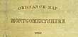
Colby,Thomas.Colonel.
Ordnance Survey Map, S.E. Harleck, Merionethshire. Number 75.
Date. Dec 1st, 1838.
London, Tower of London. Page size [22 1/2 x 16 1/2ins] folding to [4 x 6ins]. . 21 Sectional linen backed ordnance survey map.. Engraved in outline by J.W. Troggelt. The Hills by J. A. Peake......
British major-general and director of the Ordnance Survey (OS). A Fellow of the Royal Astronomical Society and Royal Society, Colby was one of the leading geographers of his time. An officer in the Royal Engineers, Colby overcame the loss of one hand in a shooting accident to begin in 1802 a lifelong connection with the Ordnance Survey. His most important work was the Survey of Ireland. He began planning this enormous enterprise in 1824 and directed it until 1846, in which year the final maps made by the survey were almost ready for issue. He was the inventor of the "Colby Bar" (a compensation bar), an apparatus used in base-measurements....... £45.00 |
Click on picture above to view more images
How to order |
(Code No. 6422)
Wood, J. G.
(Antique Map of Caernarvonshire, Anglesey and Merionethshire.)
Rivers of North Wales.
Date. 1813.
London. T Bensley. Image size. [21 x 12 1/2ins]. Original drawn and engraved hand-coloured etched map by J.G. Wood, with central folds, some off setting. Taken from "The principal Rivers of Wales illustrated; consisting of a series of Views from the source of each river to its mouth, accompanied by descriptions ..." By J.G. Wood. ...... . £50.00 |
Click on picture above to view more images
How to order |
(Code No. 6408)
Colby, Thomas Frederick & B. Baker.
Ordnance Survey Map, Montgomeryshire.
Date. 1838.
London, Tower of London. Page size [55 x 40ins] 1836-7. A glazed linen backed ordnance survey map on wooden rollers.. Engraved in outline by L. D. Elboux. Writing by J. A. Harrison. The hill engraved by R?. Tovey. Map engraved by B. Baker. Sold by J. Gardener, (agent)....... £80.00 |
Click on picture above to view more images
How to order |
(Code No. 6403)SAXTON, Christopher & William Kip.(Antique Map).DENBIGH. "Denbigh Comitatus pars Olim Ordovicum..Date. 1637.London. Printed by Georgii Bishop & Joannis Norton. Folio. Page size 16 x 13 ins. Image size 12 1/4 x 10 1/4 ins. Original copper engraved coloured map of Denbighshire engraved by W. Kip.Taken from William Camden's Britannia of 1637. A large heraldic device watermark . Plain back. very good condition....
|
SOLD.
|
(Code No. 6388)
A Panoramic sketch and a short description of the Eryri Hills; or Caernarvonshire Mountains as seen from Anglesey, with Names of the Principal Objects..
Date. (c1850. 2nd edn).
Caenarvon: H. Humphreys. 8vo, [5 1/2 x 8 3/4ins] Pp. 11 + folding panorama of the Caernarvonshire Mountains, as seen from Anglesey with the names of the Principal Objects, repaired split to fold, no loss. Fold out image size 22 x 141cm, accordion style folding to 22 x 13 cm . Decorated paper covers, slight tears to edges..... £80.00
|
Click on picture above to view more images
How to order |
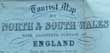
(Code No. 6336)
Tourist Map of North & South Wales with Adjoining Portion of England. From the Ordnance Survey..
(Antique map).
Date. [c.1860].
Chester. Catherall & Pritchard. 12mo. Folding sectional hand coloured in outline map of Wales and adjoining portion of England, including Cheshire, Staffordshire, Shropshire, Worcestershire and Gloucestershire, Size 385 x 420 mm folding to 90 x 140 mm. " North Wales Turnpike Road Distance Table" on front past down. Original embossed cloth gilt .... £25.00
|
Click on picture above to view more images
How to order |
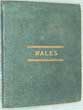
(Code No. 6335)
Hall, S.
Pocket County Maps. WALES.
Date. [c.1840].
London. Chapman and Hall.. 16mo, [3 1/2 x 4ins]. Folding sectional hand coloured in outline linen backed map of Wales. Page size 10 1/4 x 15ins]. engraved by S. Hall. Mail roads coloured blue, Coach roads brown, County divisions red. Origional cloth gilt..... £30.00 |
Click on picture above to view more images
How to order |
(Code No. 6316)
Pritchard.
(Antique Print).
Pont Aberglaslyn. (Carnarvonshire - North Wales).
Date. [c.1840].
Carnarvon, Pritchard. Page size, [12 x 17ins]. Image size, [7 x 10ins]. Original antique lithographic print ..Foxing to outer margins, not affecting image...
Pont Aberglaslyn has a bridge with a connection to the Devil. It is very similar to other Devil and bridge related stories found throughout the British Isles. The Devil built the bridge on the understanding that he would receive the soul of the first living creature to cross over it. When the bridge was finished he went to the local inn (Y Delyn Aur) to inform the magician Robin Ddu that it was ready. Robin went to inspect the new bridge with a dog he lured from the pub with a fresh baked loaf of bread. Upon seeing the bridge Robin asked the Devil whether it was sturdy and how much weight it could carry as he thought it might not even take the weight of the loaf he was carrying. The Devil was shocked and demanded that the magician throw his loaf onto the bridge to prove that it was indeed strong enough. So Robin threw the loaf onto the bridge and the dog chased it across the bridge, thus cheating the Devil of a human soul. Robin Ddu then returned to the pub to finish his drinking...... £50.00 |
Click on picture above to view more images
How to order |
(Code No. 6304)
Varley, John. Artist.
(Antique Print).
Cader Idris. (North Wales).
Date. July 1st 1818.
London, T. M. McLean. Page size [15 3/4 x 12ins]. Image size [11 x 7 1/4ins]...Original hand-coloured aquatint taken from an original drawing by J. Varley in the possession of T. Richards.
John Varley (1778 – 1842) was an English watercolour painter and astrologer, and a close friend of William Blake. They collaborated in 1819–1820 on the book Visionary Heads, written by Varley and illustrated by William Blake....... £60.00 |
Click on picture above to view more images
How to order |
(Code No. 6303)
Prout, S.G.
Caenarvon Castle.. (North Wales).
( Antique Print).
Date. [c.1850].
Caenarvon, Williams & Hughes. Page size [15 x 11ins]. Image size [10 1/2 x 7ins]. Original lithographic print, faint marginal foxing, not affecting image. Printed by Hullmandel & Walton.
Samuel Prout, (1783 -1852) was one of the masters of British watercolour architectural painting. Prout secured the position of Painter in Water-Colours in Ordinary to King George IV in 1829 and afterwards to Queen Victoria. John Ruskin, whose work often emulated Prout's, wrote in 1844, "Sometimes I tire of Turner, but never of Prout". Prout is often compared to his contemporaries; Turner, Gainsborough, Constable and Ruskin, whom he taught..... £55.00 |
Click on picture above to view more images
How to order |
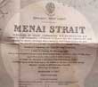
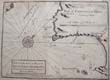
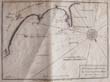
(Code No. 6282)
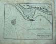
Archdeacon, Commander W.E.
(Admiralty Chart).
MENAI STRAIT. (North Wales).
Date. 23rd May, 1894.
London, Hydrographic Office,. Chart size [39 x 27ins]. Folding to [6 1/4 x 5 1/4ins]. Original Admiralty chart showing plans of anchorages in the Meanai Strait, surveyed by staff Commander W.E Archdeacon, splits and waterstaines. Sold as a working copy only. £40.00 |
Click on picture above to view more images
How to order |
(Code No. 6278)
Pickering, G.
Conway, (North Wales)..
(Antique Print).
Date. [c.1830].
Chester, Poole & Boult. Page size, [15 x 11ins]. Image size, [6 1/2 x 9 1/2ins]. Original antique lithographic print by Day & Haghe lithographers to the King. Slight foxing.
Conway Castle was built by Edward I, during his conquest of Wales, between 1283 and 1289. Constructed as part of a wider project to create the walled town of Conwy, the combined defences cost around £15,000, a huge sum for the period. Over the next few centuries, the castle played an important part in several wars. It withstood the siege of Madog ap Llywelyn in the winter of 1294-95, acted as a temporary haven for Richard II in 1399 and was held for several months by forces loyal to Owain Glynd?r in 1401...... £65.00 |
Click on picture above to view more images
How to order |
(Code No. 6260)
Hughes, H.
(Antique Print).
Interior of Carnarvon Castle. (North Wales).
Date. [c.1840].
Carnarvon, Pridchard. Page size, [12 x 17ins]. Image size, [7 x 10ins]. Original antique lithographic print drawn by H. Huges. Printed by Day & Haghe lithographers to the Queen. Slight foxing to outer margins, not affecting image........ £50.00 |
Click on picture above to view more images
How to order |
(Code No. 6259)
Llangollen Bridge. (North Wales).
(Antique Print).
Date. [c.1840].
Chester, Seacome & Pritchard. Page size, [15 x 11ins]. Image size, [6 1/2 x 9 1/2ins]. Original antique lithographic print by Day & Haghe lithographers to the Queen. Slight foxing to outer margins, not affecting image........ £65.00 |
Click on picture above to view more images
How to order |
(Code No. 6256)
Snowdon and Llanberis Lakes. (North Wales).
(Antique Print).
Date. [c.1840].
Carnarvon, M. Potter. Page size [15 x 11ins]. Image size, [10 1/2 x 7 1/4ins].Original lithographic print. Slight marginal foxing and creasing, not affecting image....... £40.00 |
Click on picture above to view more images
How to order |
(Code No. 6255)
Vale Crucis Abbey, near Llangollen. (North Wales).
( Antique Print).
Date. [c.1850]
Chester, J. Seacome. Page size [15 x 11ins]. Image size [9 1/2 x 6 1/2ins].. Original lithographic print engraved by Haghe, Slight marginal foxing, not affecting image. Printed by Day & Haghe, Lithographers to the Queen......... £40.00 |
Click on picture above to view more images
How to order |
(Code No. 6250)
THROUP, T.
Throup's North Wales cyclists' and motorists' guide.
Date. [c.1910].
Bradford, T. Throup. 8vo, [5 x 7 1/4ins]. Pp. 102 + 2 Large folding maps, one linen backed + Full page illustrations throughout, including full page adverts. Original cloth. Fine copy..... £35.00 |
Click on picture above to view more images
How to order |
(Code No. 6237)
Morris, Lewis.
(Antique sea Chart.)
Kemlyn Bay and harbour in ye north of Anglesey, and harbour. ( Anglesey, North Wales).
Date. Sept. 29 .1748, 1st edn.
(London), Published according to act of Parliament. Page size, [11 1/4 x 9ins]. Original copper engraved sea chart, engraved by N, Hill, damage, repaired on the back of chart.
Morris's marine survey of the Welsh coast, undertaken with very little official support, was a supreme pioneering achievement, especially for a self-taught hydrographer. It is for this marine survey that he is now recognized as one of the most eminent of British cartographers. ...... |
Click on picture above to view more images
How to order |
(Code No. 6236)
Morris, Lewis.
(Antique sea Chart.)
Caernarvon bar and harbour.
Date. Sept. 29 .1748, 1st edn.
(London), Published according to act of Parliament. Page size, [11 1/4 x 9ins]. Original copper engraved sea chart, engraved by N, Hill, damage repaired on the back of chart.
Morris's marine survey of the Welsh coast, undertaken with very little official support, was a supreme pioneering achievement, especially for a self-taught hydrographer. It is for this marine survey that he is now recognized as one of the most eminent of British cartographers. ..... |
Click on picture above to view more images
How to order |
(Code No. 6193)Blaeu, Joan. (1596-1673).Denbigh Comitatus et Comitatus Flintensis.( Blaeu's Map of Denbigh and Flintshire, North Wales).Date. 1645-62.Amsterdam. Image size, [19 1/2 x 15ins]. Original hand coloured copper engraved map. Decorative title cartouche and scale: Royal crests; Empty cartouche surrounded by putti; Ship entering mouth of the River Dee. Blank back. Trimmer and chipping to outer edges with printers creases. From the 'Novus Atlas'.Joan Blaeu (1598-1673) is one of the most famous of the Dutch cartographers. The fourth volume of his atlas focused on England and Wales. Blaeu established his firm in 1599 as instrument and globe makers. He went on to produce some of the highest quality atlases ever published. .......
|
SOLD.
|
(Code No. 6169)
Dodd, Arthur. Herbert.
The Industrial Revolution in North Wales.
Date. 1971, 3rd edn.
Cardiff, University of Wales Press. 8vo, . Pp.xlv, 439 + 5 maps. Original cloth gilt. Dust jacket, slight chipping to outer edges......... £35.00 |
Click on picture above to view more images
How to order |
(Code No. 6141)
Journal of the Merioneth Historical and Record Society.
Volume 7, parts 3 and 4 - Volumes 8 and 9, parts 1, 2, 3 and 4.
Date. 1975-76.
Merioneth Historical and Record Society. 4to, 1980-84. Total 7 parts. Pp. (approx), 120 per part + Illustrations throughout. Card covers.
The Society was founded in June 1939. Its object is the education of the public in the history of the former county of Merioneth, including archaeology, buildings, family history, folklore, literature and all the various subjects which come under the designation of 'antiquities'..... £35.00 |
Click on picture above to view more images
How to order |
(Code No. 6116)
Anon.
(Antique Aquatint Print).
LLANBERRIS LAKE & DOLBADRON CASTLE. (North Wales).
Date. 1822.
London. Thomas McLean. Page size [12 x 8 3/4ins]. Image size [7 1/4 x 5ins]. Beautiful original hand-coloured aquatint print......
J. M. W. Turner, Thomas Girtin and John Sell Cotman, began their careers as engravers and colourists of these types of aquatints. It is now impossible to know the artist. The hand-colouring has never bettered...... £35.00 |
Click on picture above to view more images
How to order |
(Code No. 6085)
Owen, J and E, Bowen.
(2 Antique Road Strip Maps.)
Northop, Hawarden, Chester, Denbigh, Conway, Anglesey, Beaumaris, Holyhead.
Pages 57 & 58.
Date. 1720 or later edition.
. London. Tho, Bowles. Page size 5 1/2 x 7 1/2ins. 2 Original copper engraved strip maps, (modern hand-colouring). Taken from "Britannia Depicta" a more handy version of John Ogilby's Survey of 1675......... £30.00 |
Click on picture above to view more images
How to order |
(Code No. 6050)Lewis, W. J.Lead Mining in Wales.Date. 1967. Cardiff, University of Wales Press. 8vo, [6 x 9ins]. Pp.415 + iIllustrations throughout. Original cloth. Dust jacket, slight nicks to top of spine. ..........
|
SOLD.
|
(Code No. 6044)
Palmer, Alfred Neobard.
History of the 13 country townships of the old parish of WREXHAM,
and of the townships of Burras Riffri, Erlas and Erddig.
Date. 1903.
Wrexham, Hughes and Son. 8vo, [6 x 9ins]. Pp. 264 + Illustrations throughout, (Family pedigrees, e.g Yales of Newhaven U.S.A, Maps, Views, etc). Original cloth, faded and chipping to spine.
Alfred Neobard Palmer (1847–1915) was a chemist and local historian. He published several books concerning the local history of Wrexham and North Wales......... £50.00 |
Click on picture above to view more images
How to order |
(Code No. 6019)
KEERE, Pieter van den. (1571-1646).
(Antique Map).
"Denbighshire and Flint Discribed"
Date. 1627.
. London. Humble. George. Map image size 5 x 3 1/4 ins. Map page size 6 x 4 ins. Hand coloured copper engraved miniature map of Denbighshire and Flintshire by Van De. Keere, English text on the back of map. Abridged from John Speed's The Theatre of the Empire of Great Britain. vg. Guatanteed to be over 350 years old. ..... £45.00 |
Click on picture above to view more images
How to order |
(Code No. 6013)
Kitchin, Thomas.
A Map of CARMARTHEN SHIRE
drawn from an actual Survey. (Mid Wales).
Date. [c.1760]
.London, R. Baldwin. Map Size (approx), [8 x 6 1/2ins]. Original copper engraved folding map. Taken from "The London Magazine 1763"... ...£40.00 |
Click on picture above to view more images
How to order |
(Code No. 5982)
GREENWOOD, C & J.
(Antique Map).
Maps of the County of Monmouth, from an Actual Survey Made in the Years 1829 & 1830.
Date. 1830-34.
London, Greenwood & Co. 13 Regents Street Pall Mall. Image size, (approx), 28½ x 23 ins. Original beautiful hand coloured steel engraved map with a vignette of Tintern Abbey........ £85.00 |
Click on picture above to view more images
How to order |
(Code No. 5931)Boydell, John (1720-1804), Engraver and printseller.(Antique Print).A North West View of Rhuddlan Castle, Flintshire.Date. 1744.London. J. Boydell. Image size 17 x 11 ins. Original copper engraved hand-coloured print, drawn and engraved by J. Boydell, vg.John Boydell was the most important print publisher of his day, and was responsible for the publication of some of the most impressive paintings of the period. In 1769, he launched A Collection of Prints, Engraved from the most Capital Paintings in England. A second volume was completed in 1772. In the 1790s, Boydell began a Shakespeare venture that included the establishment of a Shakespeare Gallery and the publication of an illustrated edition of Shakespeare's plays. Some of the most illustrious painters of the day contributed, but financial woes dogged the project as Britain's economy suffered during the French Revolutionary wars. The expenses were so large that Boydell died almost bankrupt.......
|
SOLD.
|
(Code No. 5854)Christiansen, Rex & R.W. Miller.The Cambrian Railways.Volume 1: 1852-88.Date. 1971.Newton Abbot, David & Charles. 8vo, Pp. 178, vii. Illustrations throughout, very good condition. Original cloth gilt. Dust jacket,
|
SOLD
|
(Code No. 5843)
SAXTON, Christopher & William Kip.
(Antique Map).
FLINTSHIRE, (North Wales).
"Comitatus quem: ordovices osim Incoluerunt".
Date. 1610.
London. Printed by Georgii Bishop & Joannis Norton. Folio. Page size 16 x 12 ins. Image size 12 1/4 x 10 1/4 ins. Original copper engraved map of Flintshire, engraved by W. Kip, Taken from William Camden's Britannia of 1610, 2nd edn. A large heraldic watermark device . Plain back..... £80.00. |
Click on picture above to view more images
How to order |
(Code No. 5842)
SAXTON, Christopher & William Kip.
(Antique Map).
DENBIGH, (North Wales).
"Denbigh Comitatus pars Olim Ordovicum"..
Date. 1610.
London. Printed by Georgii Bishop & Joannis Norton. Folio. Page size 16 x 12 ins. Image size 12 1/4 x 10 1/4 ins. Original copper engraved map of Denbighshire engraved by W. Kip, printer crease marks made when published. Taken from William Camden's Britannia of 1610, 2nd edn. A large heraldic watermark device. Plain back..... £70.00
|
Click on picture above to view more images
How to order |
(Code No. 5780)Boyd, James I. C.Narrow Gauge Railways in Mid-Wales .Date. 1970.Lingfield, Surrey: Oakwood Press. 8vo, revised and enlarged second edition. Pp. 300, very good. Original cloth gilt. Dustjacket, chipping to top and bottom of spine....
|
SOLD.
|
(Code No. 5776)KEERE, Pieter van den. (1571-1646).(Antique Map)Glamorganshire.Date. 1627.London. Humble. George. Map image size, (approx), [5 x 3 1/4 ins]. Hand-coloured copper engraved miniature map of Glamorganshire by Van De. Keere, (in modern mount), English text on the back of map, vg. Guatanteed to be over 350 years old.Van den Keere was born in Ghent, and in 1584 moved with his family for religious reasons to London. A series of 44 plates for the British Isles, from about 1599, took a long time to publish. They were based on Christopher Saxton, Ortelius, and Giovanni Battista Boazio, respectively for England and Wales, Scotland and Ireland. Later these plates came to William Humble, who issued them in 1627 as a miniature version of the atlas of John Speed. Thereby van den Keere's works were known as "Miniature Speeds"......
|
SOLD.
|
(Code No. 5775)KEERE, Pieter van den. (1571-1646).(Antique Map)Radnor, Breknok, Cardigan, and Caermarthen described.Date. 1627.London. Humble. George. Map image size, (approx), [5 x 3 1/4 ins]. Copper engraved miniature map of Radnor, Breknok, Cardigan and Caermarthen by Van De. Keere, (in modern mount), English text on the back of map. vg. Guatanteed to be over 350 years old.Van den Keere was born in Ghent, and in 1584 moved with his family for religious reasons to London. A series of 44 plates for the British Isles, from about 1599, took a long time to publish. They were based on Christopher Saxton, Ortelius, and Giovanni Battista Boazio, respectively for England and Wales, Scotland and Ireland. Later these plates came to William Humble, who issued them in 1627 as a miniature version of the atlas of John Speed. Thereby van den Keere's works were known as "Miniature Speeds"....
|
SOLD.
|
(Code No. 5774)KEERE, Pieter van den. (1571-1646).(Antique Map).Radnor, Breknok, Cardigan, and Caermarthen described.Date. 1627.London. Humble. George. Map image size, (approx), [5 x 3 1/4 ins].. Hand coloured copper engraved miniature map of Radnor, Breknok, Cardigan and Caermarthen by Van De. Keere, water stain top left corner. English text on the back of map. Guatanteed to be over 350 years old.Van den Keere was born in Ghent, and in 1584 moved with his family for religious reasons to London. A series of 44 plates for the British Isles, from about 1599, took a long time to publish. They were based on Christopher Saxton, Ortelius, and Giovanni Battista Boazio, respectively for England and Wales, Scotland and Ireland. Later these plates came to William Humble, who issued them in 1627 as a miniature version of the atlas of John Speed. Thereby van den Keere's works were known as "Miniature Speeds"........
|
SOLD.
|
(Code No. 5730)Boyd, James I.C.Narrow Gauge Rails in Mid-Wales.Date. 1952.South Godstone,The Oakwood Press. 8vo, [6 x 9ins]. Pp. 146, very good. Illustrated throughout. Original cloth gilt. dustjacket, very good.The Mid Wales Line was a standard gauge railway line that opened in 1864 as a North-South route serving central Welsh towns including Llanidloes, Rhayader, Builth Wells and Brecon. There were over 20 intermediate stations on this rural line, many minor, given the very sparse local populations.
|
SOLD.
|
(Code No. 5727)Saxton, C. / William Camden.(Antique Map.)Caernarfonshire.Caernarvo Comitatus pars olim Ordovicvm.Date. 1637.London. Printed by F.K.R.Y. Image size 10 1/4 x 12ins. Hand coloured copper engraved map by G. Hole.Taken from William Camden's "Britannia". .It is not considered that the maps were drawn by Saxton personally but rather that the details were copied from Saxton's map. Guaranteed to be over 300 years old......
|
SOLD.
|
CODE No. 5718.Morris, Lewis.(Antique sea Chart.)Plan of Dulas Bay & Harbour in the North of Anglesey.Date. Sept. 29. 1748, 1st edn.(London), Published according to act of Parliament. Page size, [11 1/4 x 9ins]. Original copper engraved sea chart, engraved by N, Hill, Some heavy creasing & margin strengthened on the back of chart.Morris's marine survey of the Welsh coast, undertaken with very little official support, was a supreme pioneering achievement, especially for a self-taught hydrographer. It is for this marine survey that he is now recognized as one of the most eminent of British cartographers.....
|
SOLD.
|
(Code No. 5649)THE QUEEN'S ALBUM of WELSH COSTUMES.Date. [c.1860].London, Rock Brothers and Payne. 12mo [4 1/2 x 3ins]. 12 glazed engraved Welsh costume plates, displayed in a pull out concertina style. Pictorial gilt decorated upper cover and embossed lower cover, vg......
|
SOLD.
|
(Code No. 5646)Lady Eleanor Butler (1739-1829) and Miss Sarah Ponsonby (1755-1831).(Antique Print).The Ladies of Llangollen at their home at Plas Newydd, Llangollen. (North Wales).Date. 1827-29.London, Day and Haghe. Mount size [13 x 18ins]. Image size, (approx), [7 x 11ins]. Original lithographic print by J. H. Lynch, ( modern mount), some marks.Eleanor Charlotte Butler was a member of one of the dynastic families of Ireland, the Butlers, the Earls (and later Dukes) of Ormond. Eleanor was considered an over-educated bookworm by her family, who resided at the Butler family seat Kilkenny Castle. Sarah Ponsonby lived with relatives in Woodstock, Ireland. She was a second cousin of Frederick Ponsonby, 3rd Earl of Bessborough, and thus a second cousin, once-removed, of his daughter the Lady Caroline Lamb. Their families lived only two miles from each other. They met in 1768, and quickly became friends. Over the years they formulated a plan for a private rural retreat at Plas Newydd, Llangollen to seclusion, private studies of literature and languages and improving their estate. Eleanor kept a diary of their activities. Their house became a haven for all manner of visitors, mostly writers such as Robert Southey, William Wordsworth, Percy Shelley, Lord Byron and Sir Walter Scott, but also the military leader Duke of Wellington and industrialist Josiah Wedgwood......
|
SOLD.
|
(Code No. 5610)PRYSE, Robert John, called Gweirydd ap Rhys.Hanes y Brytaniaid a’r Cymry.2 Volumes.Date. [1873-76]Llundain, William. Mackenzie. 4to, Pp. iv, 528, [1]. iv, 534, (Welsh text), + 72 Steel engraved tissue guarded prints by David Cox and others + 16 Engraved Welsh county maps, (as listed), very good condition Original half calf gilt, rubbed.David Cox was born on 29 April 1783 in Deritend, Birmingham, the son of a blacksmith, who went on to become one of the most important figures in British Art during the so-called Golden Age of watercolour painting. He was considered by his contemporaries to be rivalled only by Constable in his portrayal of nature's moods and the British weather. In 1852 The Spectator claimed, "in his works there are power and insight enough to swamp all the others put together......"
|
SOLD.
|
(Code No. 5601)Llandudno looking towards the Little Orms Head Caernarvonshire.(North Wales).Date. [c.1850].London, Newman & Co. Image size [11 x 8ins]. Original hand-coloured, (heightened with gum arabic), lithograph on card......
|
SOLD.
|
(Code No. 5597)Pickering, George.(Antique Print).Caernarvon. (North Wales).Date. Sept 1st 1829.Printed in London & Chester by Englemann, Graf, Coindet & Co. Published by Poole & Harding, Chester. Image size, [10 1/4 x 7ins]. 1829 Original hand-coloured mounted lithograph, (early colour), drawn from nature & on stone by G. Pickering. View of town with castle dominating, from high vantage point with figures on cliffs on foreground, the sea beyond....
|
SOLD.
|
(Code No. 5598)Llandudno & Great Orme Head Caernarvonshire.(North Wales).Date. [c.1850].London, Newman & Co. Image size [11 x 8ins]. Original hand-coloured, (heightened with gum arabic), lithograph on card.....
|
SOLD.
|
(Code No. 5576)Llanberis, Caernarvonshire, (Wales).(Antique Print.)Date. [c.1850].Wales, Lithograph by Day and Son. Image size [10 x 7ins]. Beautiful mounted original hand-coloured lithographic print, heightened with gum arabic, (no printed title below image)..
|
SOLD.
|
(Code No. 5557)Parry, R.Llandudno. its History and Natural History; Comprising a Brief Sketch of the Antiquities, Natural Productions and Romantic Scenery of the Town and Neighbourhood .Date. 1861.Llandudno. Thomas Williams. 8vo, (5 1/2 x 7 1/2 ins). Pp viii 242, (21) adverts, lacks fly leaf + Map of Conway + Large folding map of Llandudno, split to folds, no loss + 2 Full page wood cut engraved views. All edges gilt. Original gilt decorated cloth, split to front cloth hinge & faded. Holding firm.....
|
SOLD.
|
(Code No. 5552)Morris, Lewis.(Antique sea Chart.)Aberdovey, in Welch, Aber Dyfi in Meirionethshire. (Wales).Date. Sept. 29 .1748, 1st edn(London), Published according to act of Parliament. Page size, [11 1/4 x 9ins]. Original copper engraved sea chart, engraved by N, Hill, water stained & margin strengthened on the back of chart, not affecting engraved area.Morris's marine survey of the Welsh coast, undertaken with very little official support, was a supreme pioneering achievement, especially for a self-taught hydrographer. It is for this marine survey that he is now recognized as one of the most eminent of British cartographers.....
|
SOLD.
|
(Code No. 5521)Morris, Lewis.(Antique Sea Chart.)Fiscard Bay and harbour in Pembroke Shire. (Wales).Date. Sept. 29 .1748, 1st edn.(London), Published according to act of Parliament Page size, [11 1/4 x 9ins]. Original copper engraved sea chart, engraved by N, Hill, water stained & margins strengthened on the back of chart, not affecting engraved area.Morris's marine survey of the Welsh coast, undertaken with very little official support, was a supreme pioneering achievement, especially for a self-taught hydrographer. It is for this marine survey that he is now recognized as one of the most eminent of British cartographers....
|
SOLD.
|
(Code No. 5520)Morris, Lewis.(Antique Sea Chart.)Barmouth Bay and bars in Meirioneth Shire. (Wales).Date. Sept. 29 .1748, 1st edn.(London), Published according to act of Parliament Page size, [11 1/4 x 9ins]. Original copper engraved sea chart, engraved by N, Hill, water stained & margins strengthened on the back of chart, not affecting engraved area.Morris's marine survey of the Welsh coast, undertaken with very little official support, was a supreme pioneering achievement, especially for a self-taught hydrographer. It is for this marine survey that he is now recognized as one of the most eminent of British cartographers.....
|
SOLD.
|
(Code No. 5519)
Morris, Lewis.
(Antique Sea Chart.)
Aberdaron road the south east side of Bardsey Sound in Caernarvon Shire. (Wales).
Date. Sept. 29 .1748, 1st edn.
(London), Published according to act of Parliament Page size, [11 1/4 x 9ins]. Original copper engraved sea chart, engraved by N, Hill, water stained & margins strengthened on the back of chart, not affecting engraved area.
Morris's marine survey of the Welsh coast, undertaken with very little official support, was a supreme pioneering achievement, especially for a self-taught hydrographer. It is for this marine survey that he is now recognized as one of the most eminent of British cartographers..... |
Click on picture above to view more images
How to order |
(Code No. 5518)
Morris, Lewis.
(Antique Sea Chart.)
Porthdinlleyn and Nevyn in Caernarvonshire. (Wales).
Date. Sept. 29 .1748, 1st edn.
(London), Published according to act of Parliament Page size, [11 1/4 x 9ins]. Original copper engraved sea chart, engraved by N, Hill, water stained & margins strengthened on the back of chart, not affecting engraved area.
Morris's marine survey of the Welsh coast, undertaken with very little official support, was a supreme pioneering achievement, especially for a self-taught hydrographer. It is for this marine survey that he is now recognized as one of the most eminent of British cartographers.... |
Click on picture above to view more images
How to order |
(Code No. 5516)
Enderbie, Percy.
Cambria triumphans, or Britain in its perfect lustre......from the first, to Kind Charles.
Date. 1810, [A reprint of the edition of 1661, with the addition of an index.]
London, Andrew Cooke & Samuel Bagster. Folio, [11 x 14 1/2ins]. Pp. [10] 356, water staining, [24, index], some damage, slight loss + 6 copper engraved coats-of-arms + Text illustrations. Original cloth, some loss.
Enderbie lived many years in Wales, learnt Welsh, and became an enthusiast in his admiration for the Welsh nation and its history. In his foreword to Cambria Triumphans, 1661, written at Llantarnam, he states that he had found much of his material in the library of Sir Edward Morgan, his brother-in-law. His book was intended to show that 'the manner of Great Britain's Government was ever princely, and to inform the Stuarts of their Welsh ancestry.... £110.00 |
Click on picture above to view more images
How to order |
(Code No. 5515)
Roscoe, Thomas.
Wanderings and Excursions in South Wales: with the Scenery of the River Wye.
Date. [c.1830].
London, Tilt and Bogue Simpkin and Co. 8vo, [5 1/2 x 8 3/4ins]. Pp. [6], 284 + 50 Steel engraved plates, marginal foxing throughout + Folding hand-coloured map, spit to fold, (repaired). Original half morocco gilt, rubbed and chipped.
Thomas Roscoe was born in Liverpool where his father was a lawyer and MP. He was a translator and travel-writer by profession and his work included the translations of Italian, German and Spanish novelists. His main travel writing was devoted to Italy and Spain, but he did produced one book on Wales. This book is not the typical 'tourist guide' of the time and, as a result, it is far more interesting to the modern reader..... £65.00 |
Click on picture above to view more images
How to order |
(Code No. 5511)Morris, Lewis.(Antique Sea Chart.)Aberystwyth Bay, Bar and Harbour in Cardiganshire. (Wales).Date. Sept. 29 .1748, 1st edn.(London), Published according to act of Parliament Page size, [11 1/4 x 9ins]. Original copper engraved sea chart, engraved by N, Hill, water stained & margins strengthened on the back of chart, not affecting engraved area.Morris's marine survey of the Welsh coast, undertaken with very little official support, was a supreme pioneering achievement, especially for a self-taught hydrographer. It is for this marine survey that he is now recognized as one of the most eminent of British cartographers....
|
SOLD.
|
(Code No. 5502)
Morris, Lewis.
(Antique Sea Chart.)
Pwllheli Bay & Harbour in Caernarvonshire. (Wales).
Date. Sept. 29 .1748, 1st edn.
(London), Published according to act of Parliament Page size, [11 1/4 x 9ins]. Original copper engraved sea chart, engraved by N, Hill, water stained & margin strengthened on the back of chart, not affecting engraved area.
Morris's marine survey of the Welsh coast, undertaken with very little official support, was a supreme pioneering achievement, especially for a self-taught hydrographer. It is for this marine survey that he is now recognized as one of the most eminent of British cartographers. .... |
Click on picture above to view more images
How to order |
(Code No. 5501)Morris, Lewis.(Antique Sea Chart.)St Tudwals Road and Keiriad Road in Caernarvonshire. (Wales).Date. Sept. 29 .1748, 1st edn.(London), Published according to act of Parliament Page size, [11 1/4 x 9ins]. Original copper engraved sea chart, engraved by N, Hill, water stained & margin strengthened on the back of chart, not affecting engraved area.Morris's marine survey of the Welsh coast, undertaken with very little official support, was a supreme pioneering achievement, especially for a self-taught hydrographer. It is for this marine survey that he is now recognized as one of the most eminent of British cartographers. ....
|
SOLD.
|
(Code No. 5497)Morris, Lewis.(Antique Sea Chart.)Cardigan Bay Bar & Harbour in Cardiganshire.Date. Sept. 29th .1748, 1st edn.(London), Published according to act of Parliament Page size, [11 1/4 x 9ins]. Original copper engraved sea chart, engraved by N, Hill, water stained & margin strengthened on the back of chart, not affecting engraved area. Morris's marine survey of the Welsh coast, undertaken with very little official support, was a supreme pioneering achievement, especially for a self-taught hydrographer. It is for this marine survey that he is now recognized as one of the most eminent of British cartographers. ....
|
SOLD.
|
(Code No. 5484)LEWIS, Samuel.Volume 1 of 2.A TOPOGRAPHICAL DICTIONARY OF WALES, Comprising the Several Counties, Cities, Boroughs, Corporate and Market Towns, Parishes, Chapelries, and Townships.Date. 1833.London: S. Lewis & Co. 4to, [9 x 11 1/2ins]. Pp, not paginated, odd foxing spot. Text illus + 9 WELSH COUNTY MAPS including folding map of North & South Wales + Anglesey, Brecknockshire, Cardiganshire, Carmarthenshire, Carnarvonshire, Denbighshire, Flintshire and Glamorganshire by J & C Walker + 4 Loose Welsh county maps by J. Archer. Lacking, spine & lower cloth cover...
|
SOLD.
|
(Code No. 5328)Baker, J.(10 Antique Welsh Prints.)Valle Crucis Abbey, Caernarvon Castle, St John's Church Chester, Barmouth, Acton Castle, View in Wynnestay Park, Denbigh Castle, Dolbadern Castle, Brynbella the seat of G.Piozze Esq, and Ynysymaengwin.Date. [c.1795].Worcester, J.Tymbs. Page size [10 x 8ins.] Approx, image sizes [6 x 4ins] to [6 1/2 x 4 1/2ins.] 10 Loose hand-coloured aquatint prints of Wales & the English border. Taken from, "Picturesque Guide through Wales and the Marches; interspersed with the most interesting subjects of antiquity in that principality".
|
SOLD.
|
(Code No. 5307)Lhuyd, Humphrey, & Abraham Ortelius.(Antique double-page engraved map of Wales).Cambriae Typic.(THE FIRST MAP OF WALES).Antwerp. Plantin Press, Image size 19 1/2 x 13 1/2 inches. Page size 22 x 17 3/4 inches. Date. [c.1600.] Original uncoloured copper engraved map. Humphrey Lhuyd's Map, the first that was specifically a map of Wales, was published in Antwerp in 1573. Ortelius (Abraham Ortels) (April 2, 1527 - June 28, 1598) was a Belgian cartographer and geographer, generally recognised as the creator of the first modern atlas. On May 20, 1570, Gilles Coppens de Diest at Antwerp issued Ortelius' Theatrum Orbis Terrarum, the "first modern atlas" (of 53 maps). Three Latin editions of this (besides a Dutch, a French and a German edition) appeared before the end of 1572; twenty-five editions came out before Ortelius' death in 1598; and several others were published subsequently, for the atlas continued to be in demand until about 1612.
|
SOLD.
|
(Code No. 5279)
SOUTHEY, Robert.
Madoc.
Date. [c.1805]
London, Longman, Hurst. 4to, [9 x 11ins.] Pp x [2], 557, edges to preliminaries frayed, not affecting text. Including 4 engraved vignette titles. Original full calf, boards detached & leather loss, (poor).
The historical facts on which this Poem are few. On the death of Owen Gwyneth, King of North Wales, A.D. 1169, his children disputed the succession. Madoc, Gwyneth's son, left Wales and set sail to the west. There is evidence that he reached America, and that his posterity exists there to this day, on the southern branches of the Missouri, retaining their complexion, their language, and, in some degree, their arts. £55.00 |
Click on picture above to view more images
How to order |
(Code No. 5278)Lhuyd, Humphrey, & Abraham Ortelius.(Antique double-page engraved map of Wales).Cambriae Typic. (THE FIRST MAP OF WALES).Date. [c.1600.] Antwerp. Plantin Press, Image size 19 1/2 x 13 1/2 inches. Page size 22 x 17 3/4 inches. Original hand-coloured copper engraved map. numbered 21 on back of map.Humphrey Lhuyd's Map, the first that was specifically a map of Wales, was published in Antwerp in 1573. Ortelius (Abraham Ortels) (April 2, 1527 - June 28, 1598) was a Belgian cartographer and geographer, generally recognised as the creator of the first modern atlas. On May 20, 1570, Gilles Coppens de Diest at Antwerp issued Ortelius' Theatrum Orbis Terrarum, the "first modern atlas" (of 53 maps). Three Latin editions of this (besides a Dutch, a French and a German edition) appeared before the end of 1572; twenty-five editions came out before Ortelius' death in 1598; and several others were published subsequently, for the atlas continued to be in demand until about 1612.
|
SOLD.
|
(Code No. 5219)Sandby, Paul. (1725-1809).(Antique Aquatint Print.)Chepstow Castle in Monmouthshire. (South Wales.)Date. 1st September 1775.London. Publishd according to Act of Parliament by P Sandby St Georges Row Oxford Turnpike image size 10 1/4 x 8 ins, page size 12 x 15ins. Original aquatint engraved print, drawn and engraved by Paul Sandby, mark to the centre of image.Paul Sandby published the first aquatints in England, his many aquatint views of North & South Wales launched the popularity of Wales as a picturesque sketching location, coming into fashion with the beginning of the Romantic Movement.Chepstow Castle (Welsh: Cas-gwent), located in Chepstow, Monmouthshire in Wales, on top of cliffs overlooking the River Wye, is the oldest surviving stone fortification in Britain. It was built under the instruction of the Norman Lord William FitzOsbern, soon made Earl of Hereford, from 1067, and was the southernmost of a chain of castles built along the English-Welsh border in the Welsh Marches.
|
SOLD.
|
(Code No. 5213)SANDBY, Paul; (English. 1725-1809)Bangor in the County of Caernarvon. (North Wales).Date.1st September 1776.London. Page size, [16 1/2 x 12 1/2ins]. Original engraved aquatint & etching print, slight marks to outer margins. This is plate 9 out of XII of Sandby's "Twelve Views of South Wales" were the result of his 1771 tour of South Wales with Sir Joseph Banks and the Hon. Charles Greville, to whom he dedicated his set. Among the first aquatints published in England, the twelve views launched the popularity of Wales as a picturesque sketching location, coming into fashion with the beginning of the Romantic Movement.The origins of the City of Bangor date back to the founding of a monastic establishment on the site of Bangor Cathedral by the Celtic saint Deiniol in the early 6th century AD. The name 'Bangor' itself is an old Welsh word for a type of fenced-in enclosure, such as was originally on the site of the cathedral.
|
SOLD.
|
(Code No. 5210)
SANDBY, Paul; (English. 1725-1809.)
Carey Castle in Pembrokeshire.
Date. 1st September 1775.
London. Page size, [15 1/2 x 10 1/2ins]. Original engraved aquatint & etching print, slight marks to outer margins.
This is plate X out of XII of Sandby's "Twelve Views of South Wales" were the result of his 1771 tour of South Wales with Sir Joseph Banks and the Hon. Charles Greville, to whom he dedicated his set. Among the first aquatints published in England, the twelve views launched the popularity of Wales as a picturesque sketching location, coming into fashion with the beginning of the Romantic Movement.
View of Carew Castle in South Wales. The castle stands on a strategic position on a low ridge overlooking the Carew River. A timber castle was first built here by Gerald of Windsor in c.1100 but the stone castle depicted here was built by Sir Nicholas de Carew and successive generations of his family in the 13th and 14th centuries. The castle is built around a square courtyard; there are circular towers with square bases on the west side and more regular circular towers on the east side. The castle complex included two gatehouses, kitchens and a chapel tower. £130.00
|
Click on picture above to view more images
How to order |
(Code No. 5209)
SANDBY, Paul; (English. 1725-1809).
Episcopal Palace at St. Davids.
Date. 1st September 1775.
London. Page size, [16 1/2 x 12 1/2ins]. Original engraved aquatint & etching print, slight marks to outer margins.
This is plate XII out of XII of Sandby's "Twelve Views of South Wales" were the result of his 1771 tour of South Wales with Sir Joseph Banks and the Hon. Charles Greville, to whom he dedicated his set. Among the first aquatints published in England, the twelve views launched the popularity of Wales as a picturesque sketching location, coming into fashion with the beginning of the Romantic Movement.
St Davids Cathedral has been the dominant presence since the 12th century and was a popular pilgrimage destination throughout the middle ages. £130.00 |
Click on picture above to view more images
How to order |
(Code No. 5208)SANDBY, Paul; (English. 1725-1809.)The South Gate of Cardiff Castle in Glamorgan Shire.Date.1773-75.London. Page size, [16 1/2 x 12 1/2ins]. Original engraved aquatint & etching print. This is plate 2 out of XII of a complete early proofs set prior to both Boydell and Sandby imprints, 1774-75.Sandby's "Twelve Views of South Wales" were the result of his 1771 tour of South Wales with Sir Joseph Banks and the Hon. Charles Greville, to whom he dedicated his set. Among the first aquatints published in England, the twelve views launched the popularity of Wales as a picturesque sketching location, coming into fashion with the beginning of the Romantic Movement. View of Cardiff Castle, in Cardiff, South Wales. This particular site has been fortified since the Roman invasion but the first castle to be built here was constructed in c.1091 by Robert Fitzhamon. During the 1860s Cardiff Castle was transformed into a Victorian mansion by John Crichton-Stuart, third Marquess of Bute. The architect was William Burges and Capability Brown was hired to landscape the gardens. The South Gate which is depicted in this print was built at this time.
|
SOLD.
|
(Code No. 5207)SANDBY, Paul; (English. 1725-1809).Benton Castle Looking down the Reach to Milford Haven.Date.1773-75London. Page size, [13 x 10ins]. Original engraved aquatint & etching print, nick into engraved area,(1/2ins approx). This is plate XI out of XII of a complete early proofs set prior to both Boydell and Sandby imprints, 1774-75.Sandby's "Twelve Views of South Wales" were the result of his 1771 tour of South Wales with Sir Joseph Banks and the Hon. Charles Greville, to whom he dedicated his set. Among the first aquatints published in England, the twelve views launched the popularity of Wales as a picturesque sketching location, coming into fashion with the beginning of the Romantic Movement. A fair amount of the structure of Benton Castle remains, and its original character is traceable, showing it to have been a very small enclosure castle with a round keep, and another round tower on the exposed side. The ward was polygonal, and the building dates from the late 13th-century. No contemporary history of the castle is known.
|
SOLD.
|
(Code No. 5203)
Jones, John.
(3 Antique Welsh Prints.)
Beddgelert, Llyn-gwynant near Beddgelert and Snowdon, and Llyn-gwynant from the Beddgelert Road.
Date. [c.1850.]
London, J, Newman & Co. Page sizes, [17 x 12ins.] 3 Original lithographic engraved prints, (2 hand-coloured), some foxing spots & marks.
Beddgelert was once a busy port - before the construction of the Cob at Porthmadog the river was tidal and ships sailed all the way to the village centre.- and also for being the site of two wonders of Welsh mythology, the vanishing mountain and the castle of Dinas Emrys said to be where Merlin gave his first prophecy and one of the reputed sites of the Holy Grail. £65.00 |
Click on picture above to view more images
How to order |
(Code No. 5194)View of Cader-Idris from Drws y Nant.( Antique Aquatint Print.)Date. 12th Sept 1799. London, Laurie & Whittle. Page size [19 x 14ins.] Original hand-coloured aquatint showing a view from Cader-Idris Merionethshire, North Wales. The loftiest heights of the mountain chain are, Cader Idris, which rises with a three forked summit to the south of Dolgelley, near its south-eastern extremity, and from which it makes a rapid ascent to the sea-shore at Sarn-y-Bwch; Aran Mowddwy and Aran Penllyn, to the south of Bala lake.
|
SOLD.
|
(Code No. 5164)Sandby, Paul. (1725-1809).(Antique Aquatint Print.)View of the River Dee 3 miles Short of Bala, with Cader- Idris Mountain near Dolgelli, (Dolgellau), 30 miles Distant..Date. 1st September 1777.London. Publishd according to Act of Parliament by P Sandby St Georges Row. Image size 11 1/4 x 8 ins, page size 11 x 16ins. Original aquatint engraved print, drawn and engraved by Paul Sandby.Paul Sandby published the first aquatints in England, his many aquatint views of North & South Wales launched the popularity of Wales as a picturesque sketching location, coming into fashion with the beginning of the Romantic Movement. Dolgellau is a market town in Gwynedd, north-west Wales, lying on the River Wnion, a tributary of the Mawddach. It was the county town of the former county of Merionethshire
|
SOLD.
|
(Code No. 5152)MORDEN. ROBERT.(ANTIQUE MAP)South Wales.Date. 1695.London. Awnsham & others. Image size 16 1/2 x 13 ins. Page size [17 3/4 x 15 1/2 ins]. Original copper engraved coloured, ( modern colouring,) map, cropped. Ornamental title cartouche with graduated border, Morden's County maps are the first maps based on the meridian of London. Taken from Camden's Britannia of 1695..
|
SOLD.
|
(Code No. 5125)Fagan, J & S. Hughes.(Antique Print)The Wonders of the Menai Suspension and Tubular Bridges.Date. 1850 Bangor, Published by S Hughes & Day and Son. Page size [11 3/4 x 18 1/4ins.] Original hand-coloured lithographic print, marks and nicks to edges. Working example only.
|
SOLD.
|
(Code No. 5134)Sandby, Paul. (1725-1809).(Antique Aquatint Print.)CAREW CASTLE, N.W. (In the Welsh county of Pembrokeshire.)Date. 1st September 1777.London. Publishd according to Act of Parliament by P Sandby St Georges Row Oxford Turnpike image size 11 1/4 x 8 ins, page size 11 x 16ins. Original aquatint engraved print, drawn and engraved by Paul Sandby. Paul Sandby published the first aquatints in England, his many aquatint views of North & South Wales launched the popularity of Wales as a picturesque sketching location, coming into fashion with the beginning of the Romantic Movement.Carew Castle is a castle in the civil parish of Carew in the Welsh county of Pembrokeshire. The famous Carew family take their name from the place, and still own the castle. The outer ward has earthworks that were built by Royalist defenders during the English Civil War in the 1640s.
|
SOLD.
|
(Code No. 5133)Moll. Herman.( Antique Map)Denbigh and Flintshire.Date. 1724.London. H. Moll. Page size [302 x 190 mm]. Image size [345 x 220 mm]. Hand coloured copper engraved map of Denbigh and Flintshire by H. Moll. Oblong title panel, scale, list of Hundreds, graduated border and to the right and left borders Roman alters and amethyst fibulae found in Denbigh and Flintshire. Roads are according to John Ogilby's survey of 1675.
|
SOLD.
|
(Code No. 5124)Grueber, Henry.(2 Antique Prints.)Trevallyn Hall & Gwersyllt Park near Wrexham, Clwyd.Date. [c.1830]. London: Printed & Pubd. by Engelmann, Graf, Coindet & Co. Page size [15 x 11ins.] 2 Original Lithographic prints, slight marks and nicks to edges not affecting engraved surface.
|
SOLD.
|
(Code No. 5117)Ogilby. John.( Antique Road Map).Road from Gloucester to Montgomery, travelling through, Huntley, Ross-on-Wye, Michbirch, Hereford, Penbridge, Prestaine, Kington, Clunn and Montgomery .Map number. 71.Date 1675 - 98London. Date 1675 - 98. Leaf size [ 18 x 13 ins ]. Image Size [ 17 x 12.6 ins ]. Copper engraved hand coloured Strip Road Map, dark impression. Each map strip shows towns, villages, mansions with owner's name, castles, wind mills, beacons, gallows, woods, rivers, and hills etc. Elaborate title cartouche and compass roses to each map strip.John Ogilby was a topographer, printer, and map-maker, born in Edinburgh, EC Scotland, UK. A dancing teacher and theatre owner, he lost everything in the Civil War, but after the Restoration obtained court recognition and became a London publisher. The great fire of 1666 destroyed his stock but got him the job of surveying the gutted sites in the city. He established a thriving printing house and was appointed 'king's cosmographer and geographic printer'. His most important publications were engravings of maps and atlases, including Africa (1670), America (1671), and Asia (1673), and a road atlas "Britannia" (1675), unfinished at his death. He was also the first cartographer to adopt the statute mile. Scale 1inch to the mile, each mile is divided into furlongs indicated by dots in the centre of the road. Guaranteed to be over 300 years old.
|
SOLD.
|
(Code No. 5116)Ogilby. John.( Antique Road Map).The continuation of the Road from London to Montgomery, Four shire stone, Chipping Campden, Worcester, Ludlow, Montgomery.Map number. 44.Date 1675 - 98.London.Leaf size [ 18 x 13 ins ]. Image Size [ 17 x 12.6 ins ]. Copper engraved hand coloured Strip Road Map, dark impression.. Each map strip shows towns, villages, mansions with owner's name, castles, wind mills, beacons, gallows, woods, rivers, and hills etc. Elaborate title cartouche and compass roses to each map strip.John Ogilby was a topographer, printer, and map-maker, born in Edinburgh, EC Scotland, UK. A dancing teacher and theatre owner, he lost everything in the Civil War, but after the Restoration obtained court recognition and became a London publisher. The great fire of 1666 destroyed his stock but got him the job of surveying the gutted sites in the city. He established a thriving printing house and was appointed 'king's cosmographer and geographic printer'. His most important publications were engravings of maps and atlases, including Africa (1670), America (1671), and Asia (1673), and a road atlas "Britannia" (1675), unfinished at his death. He was also the first cartographer to adopt the statute mile. Scale 1inch to the mile, each mile is divided into furlongs indicated by dots in the centre of the road. Guaranteed to be over 300 years old.
|
SOLD.
|
(Code No. 5081)
Sandby, Paul. (1725-1809).
(Antique Aquatint Print).
The Entrance to Chepstow Castle.
Date. 1st September 1777.
London. Publishd according to Act of Parliament by P Sandby St Georges Row, Oxford Turnpike. Image size 11 1/4 x 8 ins, page size 11 1/4 x 8 3/4 ins. 1st September 1777. Original aquatint engraved print, drawn and engraved by Paul Sandby, no blank margins. £70.00
Paul Sandby published the first aquatints in England, his many aquatint views of North & South Wales launched the popularity of Wales as a picturesque sketching location, coming into fashion with the beginning of the Romantic Movement. |
Click on picture above to view more images
How to order |
(Code No. 5080)Sandby, Paul. (1725-1809).(Antique Aquatint Print.)Cardiff Castle from the West.Date. 1st September 1777.London. Publishd according to Act of Parliament by P Sandby St Georges Row Oxford Turnpike image size 11 1/4 x 8 ins, page size 11 x 16ins. 1st September 1777. Original aquatint engraved print, drawn and engraved by Paul Sandby. Paul Sandby published the first aquatints in England, his many aquatint views of North & South Wales launched the popularity of Wales as a picturesque sketching location, coming into fashion with the beginning of the Romantic Movement.
|
SOLD.
|
(Code No. 5079)Sandby, Paul. (1725-1809).(Antique Aquatint Print.)Inside view of Chepstow Castle looking Eastward.Date. 1st September 1777.London. image size 11 1/4 x 8 ins, page size 11 x 16ins. Original aquatint engraved print, drawn and engraved by Paul Sandby.Paul Sandby published the first aquatints in England, his many aquatint views of North & South Wales launchedthe popularity of Wales as a picturesque sketching location, coming into fashion with the beginning of the Romantic Movement.
|
SOLD.
|
(Code No. 5053)Morris, Lewis.(Antique sea Chart.)The Roads in Ramsay Sound, on St. David's Head, in Pembrokeshire.Date. Sept, 29 ,1748, 1st edn.(London), Published according to act of Parliament Page size, [11 x 9ins]. Original copper engraved sea chart, engraved by N, Hill, 2 small holes and margin strengthened on the back of chart, not affecting engraved area.Morris's marine survey of the Welsh coast, undertaken with very little official support, was a supreme pioneering achievement, especially for a self-taught hydrographer. It is for this marine survey that he is now recognized as one of the most eminent of British cartographers.
|
SOLD.
|
| (Code No. 5004)Conder, Thomas.(Antique Map of South Wales).A New Map of South Wales. Drawn from the Latest Authorities.Date. 1786. London Alex Hogg. Page size 15 x 9 1/2ins. Image size 12 1/2 x 8ins. Hand coloured copper engraved map, 2 worm holes. Taken from "Boswell’s Antiquities of England & Wales".
|
SOLD.
|
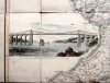
(Code No. 4992)
Walker, J. & A.
To ... the Marquis of Anglesey ... this Map of North Wales, is ... dedicated by ... J. & A. Walker. Statute miles, 15[ = 130 mm].
Date. 1824.
London & Liverpool : J. & A. Walker. 8vo slip case, [4 1/4 x 6 1/2ins.] 32 Sectional linen-backed hand coloured steel engraved map. Size 31 1/2 x 25 1/4ins. Inset vignette of " View of Menai Bridge" Original slipcase with printed title label, rubbed. Rare Map. £180.00
|
Click on picture above to view more images
How to order |
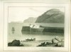
| (Code No. 4973)
William R. A. Daniell, [1769-1837].
The Bath, built by Lord Penryn, near Bangor, (North Wales).
Date. 1st May, 1815.
London. Longman & Co. Image size 9 1/2 x 6 3/4. Page size 15 x 11ins.Original aquatint, drawn and engraved by William Daniell. Taken from "A Voyage round Great Britain" No. 32, Volume 2. £55.00
William Daniell commenced a tour in a rowboat around Great Britain in the summers of the years 1813-16 starting and ending at Lands'-End in Cornwall. As he went he drew a series of 308 hand coloured sketches illustrating the character and prominent features of the coast. During the winter times he returned home to produce watercoloures and aquatints. A magnificient series of plates, almost all of equal quality . A magnificent series of plates, almost all of equal quality. Valuable as a record and exquisite in its presentation. It is the most important plate book on British Topography.
|
Click on picture above to view more images
How to order |
| (Code No. 4972)William R. A. Daniell, [1769-1837].Black Marble Quarry near Red Wharf Bay, Anglesea.Date. 1st May, 1815. London. Longman & Co. Image size 9 1/2 x 6 3/4. Page size 15 x 11ins.Original aquatint, drawn and engraved by William Daniell. Taken from "A Voyage round Great Britain" No. 27, Volume 2. William Daniell commenced a tour in a rowboat around Great Britain in the summers of the years 1813-16 starting and ending at Lands'-End in Cornwall. As he went he drew a series of 308 hand coloured sketches illustrating the character and prominent features of the coast. During the winter times he returned home to produce watercoloures and aquatints. A magnificient series of plates, almost all of equal quality . A magnificent series of plates, almost all of equal quality. Valuable as a record and exquisite in its presentation. It is the most important plate book on British Topography.
|
SOLD.
|
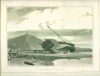
| (Code No. 4971)
William R. A. Daniell, [1769-1837].
View near Aberystwith. Cardiganshire.
Date. 1st Nov, 1814.
London. Longman & Co. Image size 9 1/2 x 6 3/4. Page size 15 x 11ins. Original aquatint, drawn and engraved by William Daniell. Taken from "A Voyage round Great Britain" No. 20, Volume 1. £55.00
William Daniell commenced a tour in a rowboat around Great Britain in the summers of the years 1813-16 starting and ending at Lands'-End in Cornwall. As he went he drew a series of 308 hand coloured sketches illustrating the character and prominent features of the coast. During the winter times he returned home to produce watercoloures and aquatints. A magnificent series of plates, almost all of equal quality. Valuable as a record and exquisite in its presentation. It is the most important plate book on British Topography.
|
Click on picture above to view more images
How to order |
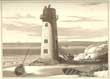
(Code No. 4970)
William R. A. Daniell, [1769-1837]:
The Lighthouse on Point of Air, Flintshire.
Date. 1816.
London. Longman & Co. Image size 9 1/2 x 6 3/4. Page size 15 x 11ins. Original aquatint, drawn and engraved by William Daniell. Taken from "A Voyage round Great Britain" No 35, Volume 2.
View shows the Lighthouse with Lake District and the top end of the Wirral in the far distance. William Daniell commenced a tour in a rowboat around Great Britain in the summers of the years 1813-16 starting and ending at Lands'-End in Cornwall. As he went he drew a series of 308 hand coloured sketches illustrating the character and prominent features of the coast. During the winter times he returned home to produce watercoloures and aquatints. A magnificent series of plates, almost all of equal quality. Valuable as a record and exquisite in its presentation. It is the most important plate book on British Topography...... £55.00 |
Click on picture above to view more images
How to order |
| (Code No. 4961)Lhuyd, Humphrey, & Abraham Ortelius.(Antique double-page engraved map of Wales).Cambriae Typic.(THE FIRST MAP OF WALES).Date. [c.1572].Antwerp. Plantin Press, Image size 19 1/2 x 13 1/2 inches. Page size 22 x 17 3/4 inches Original hand-coloured copper engraved map, water staining to bottom margin. (French text & numbered 12 on back of map.)Humphrey Lhuyd's Map, the first that was specifically a map of Wales, was published in Antwerp in 1573. Ortelius (Abraham Ortels) (April 2, 1527 - June 28, 1598) was a Belgian cartographer and geographer, generally recognised as the creator of the first modern atlas. On May 20, 1570, Gilles Coppens de Diest at Antwerp issued Ortelius' Theatrum Orbis Terrarum, the "first modern atlas" (of 53 maps). Three Latin editions of this (besides a Dutch, a French and a German edition) appeared before the end of 1572; twenty-five editions came out before Ortelius' death in 1598; and several others were published subsequently, for the atlas continued to be in demand until about 1612. From Wikipedia, the free encyclopaedia.
|
SOLD.
|
| (Code No. 4948)
MORDEN, (Robert).
[Antique Map].
The County of MONMOUTH.
Date. 1722.
London. Swale, Awnsham and Churchill. Page Size, [18 1/2 x 14 1/2ins]. Copper engraved county map of MONMOUTH by Robert Morden, based on John Speed's map. Scale, six English miles [ =1 1/2 in.]. Shell-type cartouche containing the title and Morden's name. The maps have graduated borders. Taken from Camden's Britannia of 1722. £40.00
|
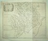
Click on picture above to view more images
How to order |
| (Code No. 4906)
Hughes. H, (1790-1863).
(Antique print.)
Carnarvon Castle and Town. (North Wales).
Date. [c.1845.]
Carnarvon, W. Pickering. Page size, 10 1/2 x 8ins. Original lithographic print by George Childs, very good condition. £45.00
Hugh Hughes, a native of Carnarvonshire, was apprenticed to an engraver in Liverpool and later moved to London where he also studied painting. He is best known for his publication "The Beauties of Cambria" (1823). George Childs exhibited landscapes at the Royal Academy, the New Water-colour Society's exhibitions, and elsewhere in London in addition to his reputation as a lithographer.
|
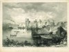
Click on picture above to view more images
How to order |
(Code No. 4870)
Prout, Gillespie. S & W. Potter.
(2 Welsh Antique Prints.)
Vale Crucis Abbey, (West Window) & Dolbadern Tower and Llanberis Lake.(Looking towards the Pass.)
Date. [c.1840-50.]
Carnarvon, W. Hughes & W. Potter. Page size [15 x 11.] Image sizes. [9 x 6 1/2ins.] & [7 x 10ins.] 2 Original lithographic prints, nicks to the outer edges well away from the images. £55.00
Valle Crucis was dissolved in 1537 as one of the lesser houses. After the Dissolution the buildings rapidly fell into disrepair; in the late 16th century the eastern range was converted into a house with a new roof-line, although this roof had gone by the early 18th century.
|
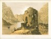
Click on picture above to view more images
How to order |
| (Code No. 4815)MORDEN, (Robert).[Antique Map.]The County of MONMOUTH.Date. 1695. London. Swale, Awnsham and Churchill. Page Size, [17 1/2 x 15ins]. Copper engraved coloured county map of MONMOUTH by Robert Morden, based on John Speed's map. Scale, six English miles [ =1 1/2 in.]. Shell-type cartouche containing the title and Morden's name. The maps have graduated borders. Taken from Camden's Britannia of 1695, repaired split to centre fold.
|
SOLD.
|
| (Code No. 4810)
Llandaff, Bishop of: Some Account of the Condition of the Fabric of Llandaff Cathedral Chiefly from 1575 to the Present Time.....
Date. 1860.
London. Rivingtons. Folio, [9 x 11 1/2ins.] Pp [3], 44, [2] + 6 Chromolithographic, (printed colour,) engraved plates + 8 Engraved lithographic plates, (as listed). Original blind stamped cloth gilt, lacking part of spine cloth. Dedication on front free end paper. £90.00
Llandaff Cathedral is the seat of the Church in Wales Bishop of Llandaff, situated in the suburb of Llandaff in the city of Cardiff, the capital of Wales. It is dedicated to Saint Peter and Saint Paul, and also to three Welsh saints: Dyfrig, Teilo and Euddogwy, and is one of two cathedrals in Cardiff, the other being the Roman Catholic cathedral in the city centre. From Wikipedia, the free encyclopedia.
|
Click on picture above to view more images
How to order |
(Code No. 4803)Sandby, Paul.(Antique Aquatint Print.)The west gate of Cardiff in Glamorganshire. (South Wales.)Date. Sept', 1777.London. image size 11 1/4 x 8 ins, page size 17 3/4 x 14ins. Original aquatint engraved print, drawn and engraved by Paul Sandby. Art historians have described Sandby as the first artist to fully understand and express the picturesque in art. The aquatint print was invented in France, eliminating the lined effect typical of eighteenth century engravings. Sandby developed the process of making aquatints so that he could recreate in a print, the look of a watercolour with varied tones and delicate patterns. In 1771 he set off from Wynnstay, Ruabon and soon became inspired by Wales' most dramatic scenery - resulting in the subsequent publication of Sandby's XII Views in North Wales. This famous series of prints, (west gate of Cardiff being one of them, plate No. 1), would help transform attitudes to Wales and even herald the arrival of the Romantic Movement in British art.
|
SOLD.
|
| (Code No. 4782)
Walton .W. L & E .W. Jacques.
(Antique Print.)
Plas Newydd near Llangollen. North Wales.
Date. [c.1850.]
Image size, [10 1/2 x 8ins.] Original lithographic print, nicks to edges, not affecting the engraved image. £50.00
Plas Newydd was the home of Lady Eleanor Butler and Sarah Ponsonby (The Ladies of Llangollen) from 1780 to 1831. They became associated with fashionable intellectual trends of the time and lived ‘in retreat’ from the world. They gothicised their home, incorporating a jigsaw of oak carvings and added stained glass windows.
|
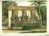
Click on picture above to view more images
How to order |
| (Code No. 4779)Hawkins. G.(Antique Print.)The Conway Tubular Bridge and Castle. (North Wales.)Date. [c.1840.]Chester, T. Catherall & Day and Sons. Page size [12 1/2 x 10ins.] Original hand-coloured lithographic print by G. Hawkins, slight marginal foxing. The Conway Tubular Bridge, which was built in 1849, and designed by Robert Stephenson (1803-1859) as part of the Chester to Holyhead Railway. The main span of the bridge is 125 metres. On the left of the image is Conwy Castle (formerly known as Conway).
|
SOLD.
|
| (Code No. 4741)
Walmsley, Thomas & F. Jukes.
(Antique Print.)
View between Llandrillo, (Llangollen), and Corwen on the River Dee.
Date. May 10th, 1793.
London. F. Jukes. Page size, 18 x 14ins. Original hand coloured aquatint taken from the original sketch by T. Walmsley and engraved by F. Jukes, slight foxing. Laid on to thick card. Dedicated to Thomas Harris Esq. £130.00
Thomas Walmsley (Landscape Artist. 1763 - 1806). After a quarrel with his family it resulted in him going to London where he worked as a scene-painter at the Royal Opera House. Up until 1795 he exhibited a series of Welsh landscape paintings at the Royal Academy London. The paintings were reissued in aquatint, this being one of them. In his 40s his health began to fail and he died in Bath in 1806.
|
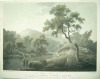
Click on picture above to view more images
How to order |
| (Code No. 4740)
William R. A. Daniell, [1769-1837].
Part of the South Stack Holyhead.
Date. 1816.
London. Longman & Co. Image size 9 1/2 x 6 3/4. Original hand coloured aquatint, drawn and engraved by William Daniell, slight foxing spots. Taken from "A Voyage round Great Britain" No 25. Volume 1. £55.00
William Daniell commenced a tour in a rowboat around Great Britain in the summers of the years 1813-16 starting and ending at Lands'-End in Cornwall. As he went he drew a series of 308 hand coloured sketches illustrating the character and prominent features of the coast. During the winter times he returned home to produce watercolours and aquatints.
A magnificent series of plates, almost all of equal quality. Valuable as a record and exquisite in its presentation. It is the most important plate book on British Topography. |
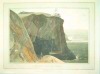
Click on picture above to view more images
How to order |
| (Code No. 4718)KEERE, Pieter van den. (1571-1646).(Antique Miniature Map)."Denbighshire and Flint Discribed".London. Humble. George. Map image size 5 x 3 1/4 ins. Map page size 6 x 4 ins. 1627. Hand coloured copper engraved miniature map of Denbighshire and Flintshire by Van De. Keere, English text on the back of map. Abridged from John Speed's The Theatre of the Empire of Great Britain. vg. Guatanteed to be over 350 years old.
|
SOLD.
|
| (Code No. 4717)KEERE, Pieter van den. (1571-1646).(Antique Miniature Map)."Anglesey and Carnarvan".Date. 1627.London. Humble. George. Map image size 5 x 3 1/4 ins. Map page size 6 x 4 ins. Hand coloured copper engraved miniature map of Anglesey and Carnarvan by Van De. Keere, English text on the back of map. Abridged from John Speed's The Theatre of the Empire of Great Britain. vg. Guatanteed to be over 350 years old.
|
SOLD.
|
| (Code No. 4712)
Kip, Joannes.
(Antique Print of Cathedral Church of St Asaph).
The Cathedral Church of St Asaph.
Date. [c.1720].
London. Page size 25 1/2 x 21ins.Original copper engraved print with hand-colour, [Engraved mainly by Joannes Kip, after drawings by Leonard Knyff]. very good. £80.00
Taken from "Nouveau Theatre de la Grande Bretagne". St Asaph was a local saint whose name is found in the neighbouring Llanasa (Asa's Church), Pantasa (Asa's Hollow), Ffynnon Asa (Asa's Well), Onen Asa (Asa's Ash-tree); these place names suggest a strong religious settlement. Asaph's name and reputation was much advanced by the creation of a new territorial episcopal see at Llanelwy in the twelfth century.
|
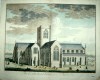
Click on picture above to view more images
How to order |
| (Code No. 4647)Lhuyd, Humphrey, & Abraham Ortelius.(Antique double-page engraved map of Wales.)Cambriae Typic. (THE FIRST PRINTED MAP OF WALES).Date. [c.1572].Antwerp. Plantin Press, Image size 19 1/2 x 13 1/2 inches. Page size 22 x 17 3/4 inches. Original hand-coloured copper engraved map, very good condition. (Latin Text & Numbered 11 on back of map.) Humphrey Lhuyd's Map, the first that was specifically a map of Wales, was published in Antwerp in 1573. Ortelius (Abraham Ortels) (April 2, 1527 - June 28, 1598) was a Belgian cartographer and geographer, generally recognised as the creator of the first modern atlas. On May 20, 1570, Gilles Coppens de Diest at Antwerp issued Ortelius' Theatrum Orbis Terrarum, the "first modern atlas" (of 53 maps). Three Latin editions of this (besides a Dutch, a French and a German edition) appeared before the end of 1572; twenty-five editions came out before Ortelius' death in 1598; and several others were published subsequently, for the atlas continued to be in demand until about 1612.
|
SOLD.
|
(Code No. 4645)Owen, J and E, Bowen.(2 Antique Strip Road Maps.)Burton, Swansea, Llanelly, Kidwelly, Haverfordwest, St DavidsandLlanfair, Tregynon. Newtown, Llanbedr, Builth Wells, Brecon.(Printed back to back on 2 single sheets,) Pages 176 & Pages 173 & 174.Date. 1720 or later edition.London. Tho, Bowles. Page size 5 1/2 x 7 1/2ins. 2 Original copper engraved strip maps, (modern hand-colouring). Taken from "Britannia Depicta" a more handy version of John Ogilby's Survey of 1675.
|
SOLD.
|
| (Code No. 4644)
Owen, J and E, Bowen.
(2 Antique Strip Road Maps.)
Llanerch, Llanbadern Vawr, Talabont, Machynlleth, Dinas Mawddy,
and
Bala, Bettws y Coed, Ruthin, Ruthin, Holywell and Exeter.
(Printed back to back on 2 single sheets,) Pages 166 & 165. Pages 39 & 40.
Date. 1720 or later edition.
London. Tho, Bowles. Page size 5 1/2 x 7 1/2ins. 2 Original copper engraved strip maps, (modern hand-colouring). 2 small splits, no loss. Taken from "Britannia Depicta" a more handy version of John Ogilby's Survey of 1675. £30.00
|
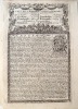
Click on picture above to view more images
How to order |
| (Code No. 4642)Owen, J and E, Bowen.(2 Antique Strip Road Maps.)Carmarthen, Cardigan, Llanbedr, Aberystwyth,andPresteign, Builth, Carmarthen.(Printed back to back on 2 single sheets,) Pages 225 & 226 & Pages 245 & 246.Date. 1720 or later edition.London. Tho, Bowles. Page size 5 1/2 x 7 1/2ins. 2 Original copper engraved strip maps, (modern hand-colouring). Taken from "Britannia Depicta" a more handy version of John Ogilby's Survey of 1675.
|
SOLD.
|
| (Code No. 4641)Cole and Roper.(4 Antique Maps of North Wales.)Anglesey, Caernarvonshire, Denbighshire and Flintshire.Date. 1809, ( watermark 1808, Whatman.)London. Vernon Hood & Sharpe. Page size [11 x 8 1/2ins.] 4 Original copper engraved maps with original outline hand-colour, fine condition. Taken from the "British Atlas", the 4to edition with the hundreds coloured in outline.
|
SOLD.
|
| (Code No. 4640)Speed John.(Antique Map of Anglesey)Anglesey.Date. 1676.London Bassett & Chiswell. Image size 20 x 15ins. Page size 16 1/2 x 21 1/2 ins. Original copper engraved map, by Jodocus Hondius, splits to edges professionally repaired on the back of map, very good. Scale of miles, 8 [= 3 5/8in].John Speed's maps are the most sought after county maps. He was born at Farndon, Cheshire, in 1552. John Speed followed his father into tailoring. John was then admitted to the Merchants Taylor's Company in 1580, becoming a historian of note. He then began his series of magnificent county maps, introducing heraldry, town plans and beautiful ornamentations, ships, sea monsters, etc.
|
SOLD
|
| (Code No. 4634)
5 Victorian letterheads, showing various Welsh views.
Date. [c.1840.]
London, Newman and others. Size 7 x 8 1/2ins & 4 1/2 x 7ins. 5 Steel engraved letterhead prints. Showing :- Holyhead, Llanrwst Bridge, Llandudno, Beaumaris Castle and Bettws y Coed, very good condition. £35.00
The Victorian letterheads usually consists of a scene or town view, the forerunner to the Picture Post Card.
|
Click on picture above to view more images
How to order |
(Code No. 4633)8 Victorian letterheads, showing various Welsh views.Date. [c.1840.]London, Harwood and others. Size 7 x 8 1/2ins. 8 Steel engraved letterhead prints. Showing :- Baron Hill, Britannia Bridge, Bangor Cathedral, Abergavenny, Beaumaris from Baron Hill, Ogwen, Plas Newydd and Beaumaris, very good condition. The Victorian letterheads usually consists of a scene or town view, the forerunner to the Picture Post Card.
|
SOLD.
|
(Code No. 4631)8 Victorian letterheads, showing various Welsh views.Date. [c.1840.] London, Harwood and others. Size 7 x 8 1/2ins. 8 Steel engraved letterhead prints. Showing :- Capel Curig, Llanberis, Penrhyn Castle, Bangor, Bettws y Coed, Caennant Mawr Llanberis, Conway Town and Glyn Garth, very good condition. The Victorian letterheads usually consists of a scene or town view, the forerunner to the Picture Post Card.
|
SOLD.
|
| (Code No. 4629)
Senex, John.
(Antique strip road map.)
The Road from Talybont, Bala, Ruthin, Holywell. No.67. Actually Surveyed by a Wheel ...
Date. 1757.
London. John Bowles and Son, The Black Horse, Cornhill, London, Page size 9 x 7 1/4ins. Original copper engraved strip map, road map, hand coloured engraving, scale about 2-2.5 miles to 1in by J. Senex. First perform'd and publish'd by John Ogilby, Esqr; And now improved, very much corrected, and made portable by John Senex. £35.00
Senex's two volume road atlas was much smaller than Ogilby's "Britannia" and would fit into a traveller's pocket. |
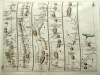
Click on picture above to view more images
How to order |
| (Code No. 4621)Speed John.(Antique Map of Anglesey)Anglesey.Date. 1610, 1st edn. London Sudbury and Humble. Image size 20 x 15ins. Page size 16 x 21 1/2 ins. Original copper engraved map, by Jodocus Hondius, nick to outer edge just affecting engraved surface. Scale of miles, 8 [= 3 5/8in.].John Speed's maps are the most sought after county maps. He was born at Farndon, Cheshire, in 1552. John Speed followed his father into tailoring. John was then admitted to the Merchants Taylor's Company in 1580, becoming a historian of note. He then began his series of magnificent county maps, introducing heraldry, town plans and beautiful ornamentations, ships, sea monsters, etc. His 1st edition maps are by far the finest example, thick paper with a rich dark impression.
|
SOLD
|
| (Code No. 4600)
Conder, Thomas.
(Antique Map of South Wales).
A New Map of South Wales. Drawn from the Latest Authorities.
Date. 1786.
London Alex Hogg. Page size 15 x 9 1/2ins. Image size 12 1/2 x 8ins. Original copper engraved print, very good condition. Taken from "Boswell’s Antiquities of England & Wales". £80.00 |
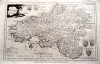
Click on picture above to view more images
How to order |
| (Code No. 4597)
Wood. J G.
(Antique View of the Town of Conway, North Wales.)
Conway.
Date. 1813.
London. Image size. 19 x 6ins. Original drawn and engraved soft-ground etching by J.G. Wood, with central fold, very good condition. Taken from "The principal Rivers of Wales illustrated; consisting of a series of Views from the source of each river to its mouth, accompanied by descriptions ..." By J.G. Wood. £70.00
|
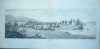
Click to view more images
How to order
|
(Code No. 4596)Wood. J G.(Antique Print of the Town of Dolgelley, North Wales.)Dolgelley.Date. 1813.London. Image size. 19 x 6ins. Original drawn and engraved soft-ground etching by J.G. Wood, with central fold , very good condition. Taken from "The principal Rivers of Wales illustrated; consisting of a series of Views from the source of each river to its mouth, accompanied by descriptions ..." By J.G. Wood.
|
SOLD.
|
(Code No. 4595)
Wood. J G.
(Antique Print of the Town of Caernarvon, North Wales.)
Caernarvon.
London. Image size. 19 x 6ins. 1813. Original drawn and engraved soft-ground etching by J.G. Wood, with central fold, very good condition.Taken from "The principal Rivers of Wales illustrated; consisting of a series of Views from the source of each river to its mouth, accompanied by descriptions ..." By J.G. Wood. £70.00
|
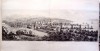
Click to view more images
How to order |
(Code No. 4552)
Thomas Gainsborough [Pinxt.]
(Antique engraved portrait print.)
Thomas Pennant Esq'. 1726-1798.
Date. 8th Jan 1782.
London. P.Mazell. Image size, 8 1/2 x 12 1/2ins. Original copper engraved portrait print by J K Sherwin [Sculpt.] £65.00
Thomas Pennant was a prolific writer specialising in travel and natural history, one of his most popular works on travel was his tour to Scotland in 1769. The correspondence he received from Gilbert White was the basis for White's book "The Natural History and Antiquities of Selborne". Unfortunately Pennant's letters to White have been lost. Ref :- List of Objects in the Thomas Pennant Exhibition 1998. No. 38. |
Click on picture above to view more images
How to order |
(Code No. 4531)
Camden, William.
CAMDEN'S BRITANNIA: or a Chorographical Description of Great Britain and Ireland, Together with the Adjacent Lands......
North Wales Section.
Date. 1722, 2nd edn.
London. Awnsham Churchill. Folio, [9 1/4 x 16ins]. Pp 778 to 840. Title in Facsimile. Descriptive text of the counties of North Wales. Text, (in 2 columns) + North Wales folding map by Robert Morden + Full-page plate + text illustrations. No Covers. £70.00
|
Click to view more images
How to order |
(Code No. 4522)Pigot & Co.’s.New Map of Wales from the latest survey.Date. [1840?]London and Manchester. Pigot & Co. 8vo, 9 3/4 x 6ins.Original steel engraved large folding map of North and South Wales, with original hand-colouring, very good condition. Page size 28 1/2 x 22 3/4ins. Modern cloth gilt, very good condition.The one and only published edition of this map. [1840?]. Not part of Pigot's "British Atlas".
|
SOLD
|
(Code No. 4517)
Pigot, James & Co.
NATIONAL COMMERCIAL DIRECTORY.
NORTH WALES.
Date. 1828-29.
London. J. Pigot & Co. 8vo, 245 x 150mm. Pp, 1143 to 1180, Title in facsimile + Folding map of North Wales with a vignette of Conway Castle, slight foxing. Modern cloth gilt. £70.00
An early directory on North Wales listing most of the principle towns, their history including the names, trades and addresses of the inhabitants, from the Accountants to the Wollen drapers. Plus carriers by land (Coaches) to carriers by water, giving times of departure and route to be taken.
|
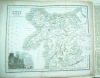
Click to view more images
How to order |
(Code No. 4513)
Sandby, Paul.
(Antique Aquatint Print.)
Dinas Bran Castle from Llangollen.
Date. [1813?].
London. Palser, Surrey. Page Size 11 1/4 x 10 1/4ins. Image size 11 x 8 ins. Original hand coloured mixed method engraving, etched and aquatint. Laid onto card. Engraved by Paul Sandby, from an original drawing by Atkington, two slight marks to engraved surface, outer edges of card boarder, marked and rubbed.
Art historians have described Sandby as the first artist to fully understand and express the picturesque in art . The aquatint print was invented in France, eliminating the lined effect typical of eighteenth century engravings. Sandby developed the process of making aquatints so that he could recreate in a print, the look of a watercolour with varied tones and delicate patterns. In 1771 he set off from Wynnstay, Ruabon and soon became inspired by Wales' most dramatic scenery, it would help transform attitudes to Wales and even herald the arrival of the Romantic Movement in British art...... Rare copy. £130.00. |
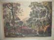
Click on picture above to view more images
How to order |
(Code No. 4512)
Sandby, Paul.
(Antique Aquatint Print.)
Conway in the County of Caernarvon.
Date. 1st Sept 1770.
London. Page Size 13 1/4 x 10 1/4ins. Image size 11 1/2 x 8 1/2ins. Original Hand Coloured Aquatint, drawn and engraved by Paul Sandby, nicks and slight marks to the outer margins, not affecting the engraved area. £130.00
Art historians have described Sandby as the first artist to fully understand and express the picturesque in art. The aquatint print was invented in France, eliminating the lined effect typical of eighteenth century engravings. Sandby developed the process of making aquatints so that he could recreate in a print, the look of a watercolour with varied tones and delicate patterns. In 1771 he set off from Wynnstay, Ruabon and soon became inspired by Wales' most dramatic scenery - resulting in the subsequent publication of Sandby's XII Views in North Wales. This famous series of prints, (Conway being one of them. Plate No. 11), would help transform attitudes to Wales and even herald the arrival of the Romantic Movement in British art.
For more information go to :-
http://www.24hourmuseum.org.uk/exh_gfx_en/ART39727.html |
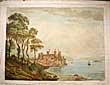
Click on picture above to view more images
How to order |
(Code No. 4462)Morden, Robert.(Antique map of North Wales.)North Wales.Date. 1695, 1st edn.London. Printed by F.Collins, for A. Swale. Page size [17 1/2 x 14 3/4ins.] Original copper engraved map by Robert Morden, cropped edges with some loss.Taken from Camden's Britannia of 1695. In the 2nd edns of Morden's map of North Wales the elaborate title cartouche is changed to a plain lined border with an altered title.
|
SOLD.
|
(Code No. 4461)Speed John.(Antique Map)Flintshire.Date. 1610, 1st edn.London Sudbury and Humble. Image size 20 x 15ins. Page size 16 x 21 1/2 ins. Original copper engraved coloured map, (modern colouring) by Jodocus Hondius, nicks to outer edges just affecting engraved surface, (1/4in) and centre fold strengthened at the back of the map. Scale of miles, 8 [= 3 5/8in.]. John Speed's maps are the most sought after county maps. He was born at Farndon, Cheshire, in 1552. John Speed followed his father into tailoring. John was then admitted to the Merchants Taylor's Company in 1580, becoming a historian of note. He then began his series of magnificent county maps, introducing heraldry, town plans and beautiful ornamentations, ships, sea monsters, etc. His 1st edition maps are by far the finest example, thick paper with a rich dark impression.
|
SOLD.
|
(Code No. 4460)Speed John.(Antique Map)Denbighshire.Date.
1610, 1st edn.London Sudbury and Humble. Image size 20 x 15ins. Page
size 18 x 21 1/2 ins. Original copper engraved coloured map, (modern
colouring) by Jodocus Hondius, nick to outer edge just affecting engraved
surface, (1/2in). Scale of miles, 8 [= 3 5/8in.].John Speed's maps are the most sought after county maps. He was born at Farndon, Cheshire, in 1552. John Speed followed his father into tailoring. John was then admitted to the Merchants Taylor's Company in 1580, becoming a historian of note. He then began his series of magnificent county maps, introducing heraldry, town plans and beautiful ornamentations, ships, sea monsters, etc. His 1st edition maps are by far the finest example, thick paper with a rich dark impression.
|
SOLD
|
(Code No. 4421)
BLAEU, Willem Janszoon (1571-1638).
(Antique Map of Denbighshire and Flintshire.).
Denbigiensis Comitatus et Comitatus Flintensis.
Date. 1645.
Amsterdam. Image size [19 3/4 x 15 1/2ins.] Original hand coloured copper engraved map, marginal marks. Latin text. £110.00
Dutch cartographer and printer. He studied astronomy and instrument making under the Danish astronomer Tycho Brahe. The printing establishment he founded in Amsterdam was famed for its fine instruments, marine publications, globes and atlases, and especially for the folio atlas that he compiled. Blaeu designed new presses incorporating important innovations; his shop was recognized as one of the best in that period. The sons and grandsons of Blaeu continued his work. Ref. The Columbia Encyclopedia, Sixth Edition.
|
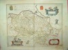
Click on picture above to view more images
How to order |
(Code No. 4374)PUGH. (Edward.)Cambria Depicta: A Tour Through NORTH WALES, Illustrated with Picturesque Views. By a Native Artist.Date. 1816.2 Volumes.London. W.Clowes. Royal 4to, (11 x 9ins.) Title page (v. Blank) + Preface pp.viii + Contents pp. xii + List of Plates pp. xv + Text pp.1- 476, some marginal spotting, images very good. Lacking text pages 203 - 205. Original half calf gilt. Raised spine bands gilt, rubbing and damage to lower cover. Bound without plates, as published.47 of 71 BEAUTIFUL ORIGINAL HAND COLOURED ENGRAVED AQUATINTLOOSE PLATES Taken from “Cambria Depicta” By EDWARD PUGH. Date 1816 + One engraved aquatint plates of South Stack, Holyhead by W. Daniell + 15 various copper engraved views of North Wales by Sparrow + 5 various copper engraved views of North Wales by Angus, Moses Griffith & others + 4 Maps of North Wales including Ellis's North Wales ca1780, Denbigh by T. Kitchin, ca1780 and 2 maps by Saxton Kip of Flintshire & Denbigh, date 1610. All plates & maps housed loose in a contemporary morocco folder. Edward Pugh, a Welshman, described and drew the inhabitants, views and customs for Cambria Depicta, He took ten years and walked between two and three thousand miles, over one of the roughest districts of Great Britain, He died at Ruthin in 1813, three years before the book was finally published.
|
SOLD.
|
(Code No. 4372)Ogilby. John.( Antique Road Map).St Davids to Holywell,Map number. 67.Date 1675 - 98.London. Leaf size [ 19 x 15 ins ]. Image Size [ 18 x 12 3/4 ins ]. Copper engraved Road Map. Each map strip shows towns, villages, mansions with owner's name, castles, wind mills, beacons, gallows, woods, rivers, and, hills etc. Elaborate title cartouche and compass roses to each map strip. .John Ogilby was the first cartographer to adopt the statute mile. Scale 1inch to the mile, each mile is divided into furlongs indicated by dots in the centre of the road. Map route - Cardigan, Bala, Ruthin & Holywell. Guaranteed to be over 275 years old.
|
SOLD.
|
(Code No. 4366)
Robinson J. H.
PEMBROKE CASTLE, from the east moonlight.
Date. 1832.
London. R. Ackermann. Page size 13 x 9 1/2ins. Original hand-coloured engraved lithograph by G Childs. Printed by Miguire & Lemercier & Co. £60.00
Pembroke Castle is a Norman stronghold dating to the time of William the Conqueror, most of the present castle dates from the 13th century. The castle is probably most closely associated with two strong Welsh Marcher Lords, Richard de Clare and William Marshal. Pembroke is also famous as the birthplace of Henry Tudor, later King Henry VII. |
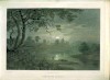
Click on picture above to view more images
How to order |
(Code No. 4285)Broughton. (Brian) PICTURESQUE VIEWS in NORTH WALES, engraved in Aquatinta by Alken, from Drawings made on the spot: with Political Reflections on leaving that Country.London. J. Mawman. 1801. 4to [10 1/2 x 8 1/2 ins]. Pp 32, some words with faint ink underlining throughout. HAND COLOURED AQUATINT VIEW PLATES, by S. Alken, slight marginal spotting. Full vellum style gilt, marked.
|
SOLD
|
(Code No. 4284)
Rees, Thomas.
SOUTH WALES.
The Beauties of England and Wales or Original Delineation, Topographical, Historical, and Descriptive of Each County.
Date. 1815.
London. Harris; Longman & Co. 8vo, [6 x 8 1/2 ins.] Volume xviii. Pp viii 917 (55) + 30 copper engraved plates, slight water staining. Original half calf, poor. Describing the counties of Brecknockshire, Glamorganshire, Pembrokeshire, Cardiganshire, Carmarthenshire, and Radnorshire....£60.00 |
Click on picture above to view more images
How to order |
(Code No. 4225)
Walmesley
Pont Newith near St Asaph.
(North Wales).
Date, June 25th 1810.
London. John Murphy. Size (approx) 13 x 10 ins. Original hand-coloured aquatint by Hill, slight creases and marks to the outer margins. £60.00
|
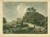
Click on picture above to view more images
How to order
|
(Code No. 4214)Morden, Robert.A New and Correct Map of North-Wales.London. Printed by F.Collins, for A. Swale. 1722. Page size [18 x 15 1/4 ins.] Original copper engraved map by Robert Morden. Taken from Camden's Britannia.
|
SOLD
|
(Code No. 4120)Holyhead and North Wales Gas and Water Corporation Limited.PWLLHELI GAS.Application for Provisional Order. Nov' 1910.G, Falkner, Manchester. Folio, [29 x 22 ins.] Title + Additional title + 2 Large lithographic plans. Showing - Plan, "Shewing Limits of Supply" and Plan of Pwllheli Gas Works, including adjacent named owners, farms, workhouse, roads, etc.
|
SOLD
|
(Code No. 4115)WOODWARD. B. B.THE HISTORY of WALES, From the Earliest Times, to its final incorporation with the Kingdom of England.5 Volumes.London. Virtue. 1864. 4to, [7 x 10 ins]. Pp vi, (ii), 608 + Engraved title + 75 steel engraved plates ( as listed), takenfrom drawings by H. Gastineau, marginal foxing and one plate with nicks to blank margin. Original cloth gilt, lacks one spine and some wear to other volumes.
|
SOLD.
|
(Code No. 4098)
Anon.
(Watercolour & 6 Sepia Sketches of Wales.)
Views of Wales.
15th to the 23rd August 1851. Page size (approx) 13 x 10 ins. Image size (approx) 10 x 7 ins. Loose Watercolour + 6 sepia sketches of Welsh scenes by an amateur artist. Harlech Castle, Maentwrog from Tan-y-bwlch, Llyn Idwal, Bridge near llyn Ogwen, Interior of Conway Castle, Abbey Church of Valle Crucis and Part of the Vale of Ffestiniog. £75.00
|

Click on picture above to view more images
How to order |
(Code No. 4078 DP)
Bowen, Emanuel, John Owen, & John, Ogilby,
(Antique Map.)
MONA, now called ANGLESEY ISLAND.
London. T, Bowles. King of Spain. 1720 or later. Size of page, 6 x 8 ins. Original copper engraved map, taken from "Britannia Depicta or Ogilby Improv'd". Very good condition. £35.00
|
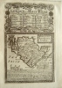
Click on picture above to view more images
How to order |
(Code No. 4040)
5 WELSH PEASANT COSTUME PRINTS.
London. Newman & Co. ca1830. Page size 4 1/2 x 7 ins. Image size
(approx) 4 x 4 ins. 5 Loose steel engraved Welsh costume prints, slight
spotting throughout, (possibly vignette letterheads). Showing - Wedding,
Farmer workers, etc. £60.00 |
Click on picture above to view more images
How to order |
(Code No. 3982)COLLINS (GREENVILLE) Capt.(Antique sea chart of Anglesey, North Wales)Holy-Head.London .1693 or later edition. Page size 24 1/4 x 21 ins. Image Size 17.1/2 x 22.ins Double-page engraved marine chart, hand-coloured, with part of Anglesey and the Holyhead shoreline, Taken from G. Collin's Great Britain’s Coasting Pilot, he was appointed to survey the coasts of Great Britain and adjacent islands by the then Secretary of the Admiralty, Samuel Pepys.
|
SOLD
|
(Code No. 3980)Speed [John](Antique Map)CARDIGANSHIRE.London.
Bassett & Chiswell, 1676. Image size approx 380 x 510mm (approx 15 x 20 inches). Hand coloured ( engraved area sized ), copper engraved map. Inset town plan of Cardigan, title, Coat of arms, imprint and scale within elaborate cartouches. Compass rose. Taken from Speed's "The Theatre of the Empire of Great Britain" Minor
nicks to engraved borders.Cropped blank margins top and bottom, not
affecting engraved area.
|
SOLD
|
(Code No. 3948)
CRAWSHAY-WILLIAMS, Eliot. 1879-1962:
No One Wants Poetry
Newtown. The Welsh Outlook Press. (1938). 8vo, (9¾ x 7½ ins) Pp.66 + 4 full-page drawings by Myfanwy Haycock. The author was born, Marthyr Tydfyl, Glamorganshire. Original decorated boards. £28.00
|
Click on picture above to view more images
How to order |
(Code No. 3945)
Catherall, T.
Catherall's Picturesque in views in North Wales.
Chester & Bangor. Pub T, Catherall. ca1850, 1st series. 8vo, [ 215 x 135mm.] Hand coloured engraved title + 13 Hand coloured (amateur style) steel engraved plates, slight foxing throughout. Decorated cloth gilt, faded. £100.00
|
Click on picture above to view more images
How to order |
(Code
No. 3778).Pennant. Thomas.A Tour in Wales.London. Benj'. White. 4to [8 x
10 ins.] Engraved vignette title page +
copper engraved plates [as listed] some folding, vg.
Illustrations taken from drawings by Moses Griffith an untrained
Flintshire artist who also accompanied Thomas Pennant on their tour
of Scotland in 1772. Original half calf, rubbed and scuffed. Split
to hinges, still firm and holding. This volume covers Chester, Holt,
Bangor, Overton, Ellesmere, Oswestry, Llangollen, Wrexham, Mold
and Caerwis, Pennant states that the two volumes of his
Tours in Wales are complete in themselves. In the "Advertisement
" Pennant requests from his fellow countrymen, further information
to assist him with volume two.
|
SOLD
|
(Code
No. 3712).
SAXTON, Christopher & RobertVaughan.
(Antique Map)
Breconshire, "Brecknoc Comitaus pars Olim Silvrvm"..
London. Printed by Georgii Bishop &
Joannis Norton. 1637. Folio. Page size 16 x 13 ins. Image size 12
x 10 1/2 ins. Original copper engraved map of Breconshire . Taken
from William Camden's Britannia of 1637. A large heraldic device
watermark . Plain back. £90.00
|
Click on picture above to view more images
How
to order |
(Code
No. 3704).
CRANE. W. (Antique Print).
The Menai Bridge.
Chester. ca1840. Page size 13 1/4 x
10 ins. Image size 11 1/2 x 7 1/2 ins. Original lithographic
print of the Menai Bridge. Thomas Telford (1757-1834) started
work on the Menai Suspension Bridge in 1819, and it was completed
and opened on 30th Jan 1826. He was also responsible for the extensive
improvements on the Holyhead to London road. His improvements to
the road took 9 hours off the previous journey time. £60.00
|
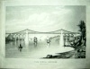
Click on picture above to view more images
How
to order |
(Code
No. 3644)
Bacon. G, W. (2 Folding Wall Maps, North & South).
"Map of England & Wales Showing Railways, Roads,
and Distances"
Oxford. G W, Bacon, Chart Publishing
Co., Nd, ca1920s. Sizes 40 x 25 ins each. Folding to 7 x 10 ins.
2 Coloured, sectional linen backed wall maps of the British
Isles with an inset map of "Main Roads out of London",
one section with split to hinge. Also showing Railway Company's
lines with abbreviation key, Principal racecourses, Aerodromes &
Seaplane stations: R.A.F and Civil.. Scale 1in = 8 mls, Original
cloth gilt, slight marks. £40.00
|
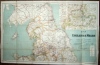
Click on picture above to view more images
How to order |
(Code
No. 3479)
(Antique Print)
Johnston.: "Valley Crusis Abbey Cardigonshire"
Valley Crucis Abbey, North Wales.
London. Deacon & Co. Page size 18
1/4 x 13 1/2 ins. Image size 18 x 12 3/4 ins. ca1800. Original hand
coloured copper engraved & drawn plate by Johnston, nicks to
edges of plate. £90.00
|
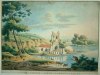
Click on picture above to view more images
How
to order |
(Code
No. 3466)
Walmesley.
( Antique Coloured Print )
"Near Mellach Court, South Wales".
London. J. Murphy, Fitzroy Square. Page
size 20 x 14 ins. Image size 12 x 8 1/2 ins. Jan 8th 1810. Original
hand coloured aquatint engraving by Hill from the original drawings
by Walmesley. Guaranteed to be over 150 years old. £88.00
|
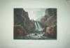
Click on picture above to view more images
How
to order |
(Code
No. 3463)
Wood. J G.
(5 Large Antique Aquatint Prints)
"View of Llangollen Vale" "Part of Dyffwys
near Corwen" "The Village of LLangollen from Craig Y Gath"
"Llangollen Bridge" and "A Fall on the Dee near Llangollen"
London. J.G. Woods, New Bond Street.
Image sizes approx 12 x 9 ins. Oct, 1793. Original aquatint print
by M.C.Prestel from the original drawings by J.G. Woods. Guaranteed
to be over 200 years old. Very rare. £800.00
|
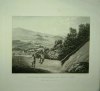
Click on picture above to view more images
How
to order |
(Code
No. 3460)
Anon. (Antique Print)
St. Winefride's Well, Holywell, North Wales.
London. R. Sayer, Fleet Street. Image
size 15 3/4 x 9 1/4 ins. Date ca1780. Original hand coloured copper
engraved print. English and French text. Guaranteed to be
over 200 years old. £90.00
|
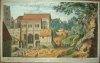
Click on picture above to view more images
How
to order |
(Code
No. 3445)Boydell. J."A North West view of Caernarvon Castle" North
Wales.London. J. Boydell. 1749. Image size
17 x 11 ins. Page size 21 1/2 x 16 ins. Original copper engraved
plate, drawn and engraved by J. Boydell, vg. Guaranteed
to be over 250 years old.
|
SOLD
|
(Code
No. 3355Bacon. G. W.(Antique Map)
Bacon's Popular Map of England and Wales from the Ordnance SurveyLondon. G. W. Bacon & Co. Size 25 1/2 x 34 1/2 ins, folding
to 7 1/2 x 5 ins. 1876. Beautiful hand coloured sectional linen
backed map engraved on steel by E. Weller, Arranged around the map
area there are 8 vignette town plans & their environs. London,
Birmingham, Manchester, Sheffield, Leeds, Liverpool, Durham
and Newcastle. Scale 12 miles to the inch. Coloured coded listings of
railways, canals, County boundaries and Parliamentary Divisions.
Original blind stamped cloth ,vg.
|
SOLD.
|
| (Code No. 3304)The Times' Contour Motoring Map of ENGLAND and WALES in 10 Sheets,
Scale 3 Miles to 1 inch.
London. Geographia Ltd. No date, ca1930. De luxe edition. Approx size
395 x 310 ins, folding to approx 10 x 15 1/2 ins. Large- scale linen
backed 80 sectional coloured contour motoring map by Alexander Gross,
some slight marks, vg. Divided into 10 mile squares. Roads, footpaths,
stations, golf cources etc, coloured coded. Original slipcase with
strap handle, lock and rear perspex window, some ware, no loss. Front
paper title label, part missing. |
SOLD
|
(Code
No. 3273)
Boydell. J.
( Antique Print )
"A North West View of Rhuddlan Castle Flint "
London. J. Boydell. 1744. Image size 17 x 11 ins. Page size 22 1/2
x 16 1/2 ins. Original copper engraved plate drawn and engraved
by J. Boydell, vg. £180.00
|
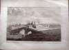
Click on picture above to view more images
How
to order |
| (Code No. 2355) Britton. John and Edward Wedlake Brayley.: The Beauties of England and Wales. CAERNARVONSHIRE. London. J Harris & others. ca1815. Demy 8vo. [ 8 1/2 x 5 1/2 ins]. Pp 299 - 480. 9 Copper engraved view plates. Original cloth gilt. rubbed. slight damage to spine. |
SOLD |
| (Code No. 2354) Britton. John and Edward Wedlake Brayley.: The Beauties of England and Wales. MERIONETHSHIRE. London. J Harris & others. ca1815. Demy 8vo. [ 8 1/2 x 5 1/2 ins]. Pp 885-959. (11) 9 Copper engraved view plates. Original cloth gilt. rubbed. Split to hinges still holding and damage to spine. |
SOLD |
(Code No. 3298)
Weekly Dispatch Atlas. ENGLAND and WALES in TWO PARTS,
(NORTH & SOUTH )
(Large-Scale Antique Map)
London. Day & Son. ca1860. Page sizes 24 x 18 ins. 2
LARGE FOLDING HAND COLOURED LITHOGRAPHIC MAPS Engraved
by E. Weller, vg. £30.00 |
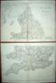
Click on picture above to view more images
How
to order |
Return to top
|
|